United States ZIP Code: 70448
This is the Louisiana ZIP Code 70448 page list. Its detail State, County, City, Longitude, Latitude, Envelope Example, Population is as below.

ZIP Code 70448 Information

-
-
Country:
U.S. - United States
State:
State FIPS:
22
Area Code:
ZIP Code:
70448
ZIP Type:
S (Standard)
❓What does S (Standard) mean? A "standard" ZIP Code is what most people think of when they talk about ZIP Codes - essentially a town, city, or a division of a city that has mail service.
ZIP Code 70448 - City

This is the city information corresponding to 70448:
| State | County | City | City Type ?In many cases, a ZIP Code can have multiple "names", meaning cities, towns, or subdivisions, in its boundaries. However, it will ALWAYS have exactly 1 "default" name. D - Default - This is the "preferred" name - by the USPS - for a city. Each ZIP Code has one - and only one - "default" name. In most cases, this is what people who live in that area call the city as well. A - Acceptable - This name can be used for mailing purposes. Often times alternative names are large neighborhoods or sections of the city/town. In some cases a ZIP Code may have several "acceptable" names which is used to group towns under one ZIP Code. N - Not Acceptable - A "not acceptable" name is, in many cases, a nickname that residents give that location. According to the USPS, you should NOT send mail to that ZIP Code using the "not acceptable" name when mailing. | ZIP Code |
|---|---|---|---|---|
| LA | Saint Tammany | Hootenville | N (Not Acceptable) | 70448 |
| LA | Saint Tammany | Lewisburg | N (Not Acceptable) | 70448 |
| LA | Saint Tammany | Mandeville | D (Default) | 70448 |
❓What does D (Default) mean? This is the "preferred" name - by the USPS - for a city. Each ZIP Code has one - and only one - "default" name. In most cases, this is what people who live in that area call the city as well.
❓What does N (Not Acceptable) mean? A "not acceptable" name is, in many cases, a nickname that residents give that location. According to the USPS, you should NOT send mail to that ZIP Code using the "not acceptable" name when mailing.
ZIP Code 70448 Plus 4
ZIP Code 5 plus 4 is the extension of 5-digit zip code, It can be used to locate a more detailed location. The last four digits designate segment or one side of a street or an apartment. You can find the ZIP+4 code and corresponding address of the zip code 70448 below.
| ZIP Code 5 Plus 4 | Address |
|---|---|
| 70448-0001 | 99201 BRIELANK ST, MANDEVILLE, LA |
| 70448-1000 | 1800 E RIDGE DR, MANDEVILLE, LA |
| 70448-1001 | 1801 E RIDGE DR, MANDEVILLE, LA |
| 70448-1002 | 1800 PALMER CT, MANDEVILLE, LA |
| 70448-1003 | 1801 PALMER CT, MANDEVILLE, LA |
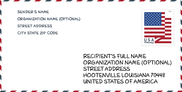
Envelope Example

This is an example of a US zip envelope. You can use a 5-digit zipcode or a detailed 9-digit zipcode to copy the mail in the following address format.
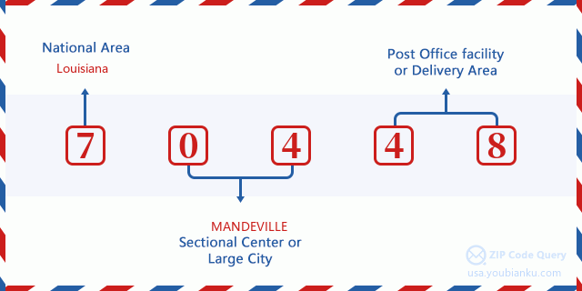
70448 Basic Meaning
What does each digit of ZIP Code 70448 stands for? The first digit designates a national area, which ranges from zero for the Northeast to nine for the far West. The 2-3 digits are the code of a sectional center facility in that region. The last two digits designate small post offices or postal zones.
Online Map

This is online map of the address Mandeville, Louisiana, United States. You may use button to move and zoom in / out. The map information is for reference only.
Hospital

This is the ZIP Code 70448 - Hospital page list. Its detail Hospital Name, Street, City, State, ZIP Code, Phone is as below.
- Name: NORTHLAKE BEHAVIORAL HEALTH SYSTEM
- Address: MANDEVILLE
- City: 23515 HIGHWAY 190
- State: LA
- ZIP Code: 70448
- Phone: (985) 626-6300
Library

This is the ZIP Code 70448 - Library page list. Its detail Library Name, Address, City, State, ZIP Code, Phone is as below.
- Name: MANDEVILLE BRANCH
- Address: 844 GIROD ST.
- City: MANDEVILLE
- State: LA - Louisiana
- ZIP Code: 70448
- Phone: (985) 626-4293
School

This is the ZIP Code 70448 - School page list. Its detail School Name, Address, City, State, ZIP Code is as below.
| School Name | Address | City | State | Grades | ZIP Code |
|---|---|---|---|---|---|
| Magnolia Trace Elementary School | 1405 Highway 1088 | Mandeville | LA | UG | 70448 |
| Mandeville Elementary School | 519 Massena Street | Mandeville | LA | UG | 70448 |
| Mandeville Middle School | 2525 Soult Street | Mandeville | LA | UG | 70448 |
| Lake Harbor Middle School | 1700 Viola Street | Mandeville | LA | UG | 70448 |
| Mandeville Junior High School | 639 Carondelet Street | Mandeville | LA | UG | 70448 |
| L.P. Monteleone Junior High School | 63000 Blue Marlin Drive | Mandeville | LA | UG | 70448 |
| Woodlake Elementary School | 1620 Livingston Street | Mandeville | LA | UG | 70448 |
| Marigny Elementary School | 1715 Viola Street | Mandeville | LA | UG | 70448 |
Population for ZIP Code 70448

What is the total population in ZIP Code 70448? Below is detail information.
- Population for ZIP Code 70448: 27,858
- 2010 Population: 24,851
The 2020 demographic statistics are in progress. The current population in ZIP code 70448 is 27,858, and the population in 2010 is 24,851.
Gender

In all the statistical population, the male population is 11,974, the female population is 12,877.
- Male Population: 11,974
- Female Population: 12,877
Race

In all the statistical population, the male population is 11,974, the female population is 12,877.
- White Population: 23,158
- Black Population: 1,075
- Hispanic Population: 1,342
- Asian Population: 414
- Hawaiian Population: 16
- Indian Population: 207
- Other Population: 376
Age

In all the statistical population, the White population is 23,158, the Black population is 1,075, the Hispanic population is 1,342, the Asian population is 414, the Hawaiian population is 16, the Indian Ppopulation is 207 and Other population is 376.
- Age's Median: 38.2
- Median of male age: 37.2
- Median of female age: 39.0
Households for ZIP Code 70448
ZIP code 70448 has 9,041 households, with an average number of 2.72 persons per household. The average income per household in Zip code 70448 is 85,028 USD, and the average house value is 257,100 USD.
- Households Per Zipcode: 9,041
- Persons Per Household: 2.72
- Average House Value: 257,100
- Income Per Household: 85,028
Geographic

The latitude of the Zip code 70448 is 30.356730, the longitude is -90.048993, and the elevation is 10. It has land area of 21.94 square miles, and water area of 2.759 square miles. The time zone for ZIP code 70448 is Central (GMT -06:00). Daylight saving time should be observed in the area where the zip code is located.
- Latitude: 30.356730
- Longitude: -90.048993
- Elevation: 10
- Land Area: 21.94
- Water Area: 2.759
- Time Zone: Central (GMT -06:00)
- Region: South
- Division: West South Central
- Day Light Saving: Y
Congressional District

The Congressional District for ZIP code 70448 is Louisiana's 1st congressional district, the Congressional Land Area is 4030.23 square mile.
- Congressional District: 1st
- Congressional Land Area: 4030.23
Delivery

In the ZIP code 70448, there are 10,242 residential delivery mailboxes and centralized units, and 741 commercial delivery mailbox and centralized units, 9,295 single family deliveries and 577 multifamily deliveries, and the box count is 10,958. The main post office has city delivery carrier routes for the ZIP code 70448.
- Delivery Residential: 10,242
- Delivery Business: 741
- Delivery Total: 10,958
- Single Family Delivery Units: 9,295
- Multi Family Delivery Units: 577
- City Delivery Indicator: Y
Business

In ZIP code 70448, the number of business is 626, the number of employee is 5,439, the business first quarter payroll is 51,756,000 USD, the business annual payroll is 219,880,000 USD.
- Number Of Businesses: 626
- Number Of Employees: 5,439
- Business First Quarter Payroll: 51,756,000
- Business Annual Payroll: 219,880,000
Social Security Benefits

There are 4,105 beneficiaries with benefits in current-payment status for ZIP code 70448, of which 2,985 are retired workers, 395 are disabled workers, 305 are widow(er)s and parents, 170 are spouses and 250 are children. The number of beneficiaries aged 65 or older is 3,290. The total monthly benefits are 6,233,000 USD, of which 4,840,000 USD for retired workers, 475,000 USD for widow(er)s and parents.
- Total Number: 4,105
- Retired workers Number: 2,985
- Disabled workers Number: 395
- Widow(er)s and parents Number: 305
- Spouses Number: 170
- Children Number: 250
- All beneficiaries per month: 6,233,000
- Retired workers per month: 4,840,000
- Widow(er)s and parents per month: 475,000
- Number of beneficiaries aged 65 or older: 3,290


Add new comment