ZIP Code: 70634, Deridder, LA
ZIP Code 70634 is located in Deridder, Louisiana. Its detail State, County, City, Longitude, Latitude, Envelope Example, Population is as below.

ZIP Code 70634 Information

-
-
Country:
U.S. - United States
State:
County FIPS:
22011
City:
Area Code:
City Type ?In many cases, a ZIP Code can have multiple "names", meaning cities, towns, or subdivisions, in its boundaries. However, it will ALWAYS have exactly 1 "default" name. D - Default - This is the "preferred" name - by the USPS - for a city. Each ZIP Code has one - and only one - "default" name. In most cases, this is what people who live in that area call the city as well. A - Acceptable - This name can be used for mailing purposes. Often times alternative names are large neighborhoods or sections of the city/town. In some cases a ZIP Code may have several "acceptable" names which is used to group towns under one ZIP Code. N - Not Acceptable - A "not acceptable" name is, in many cases, a nickname that residents give that location. According to the USPS, you should NOT send mail to that ZIP Code using the "not acceptable" name when mailing.:
D (Default)
ZIP Code:
70634
❓What does D (Default) mean? This is the "preferred" name - by the USPS - for a city. Each ZIP Code has one - and only one - "default" name. In most cases, this is what people who live in that area call the city as well.
ZIP Code 70634 Plus 4
ZIP Code 5 plus 4 is the extension of 5-digit zip code, It can be used to locate a more detailed location. The last four digits designate segment or one side of a street or an apartment. You can find the ZIP+4 code and corresponding address of the zip code 70634 below.
| ZIP Code 5 Plus 4 | Address |
|---|---|
| 70634-0001 | PO BOX 1, DERIDDER, LA |
| 70634-0121 | PO BOX 121, DERIDDER, LA |
| 70634-0241 | PO BOX 241, DERIDDER, LA |
| 70634-0361 | PO BOX 361, DERIDDER, LA |
| 70634-0481 | PO BOX 481, DERIDDER, LA |
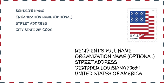
Envelope Example

This is an example of a US zip envelope. You can use a 5-digit zipcode or a detailed 9-digit zipcode to copy the mail in the following address format.
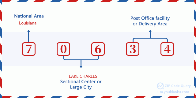
70634 Basic Meaning
What does each digit of ZIP Code 70634 stands for? The first digit designates a national area, which ranges from zero for the Northeast to nine for the far West. The 2-3 digits are the code of a sectional center facility in that region. The last two digits designate small post offices or postal zones.
Online Map

This is online map of the address Deridder, Louisiana, United States. You may use button to move and zoom in / out. The map information is for reference only.
Hospital

This is the ZIP Code 70634 - Hospital page list. Its detail Hospital Name, Street, City, State, ZIP Code, Phone is as below.
| Name | Address | City | State | ZIP Code | Phone |
|---|---|---|---|---|---|
| BEAUREGARD MEMORIAL HOSPITAL | 600 S PINE STREET | DERIDDER | LA | 70634 | (337) 462-7100 |
| OCEANS BEHAVIORAL HOSPITAL OF DERIDDER | 1420 BLANKENSHIP DRIVE | DERIDDER | LA | 70634 | (337) 460-9472 |
Museum

This is the ZIP Code 70634 - Museum page list. Its detail Museum Name, Street, City, State, ZIP Code, Phone is as below.
- Name: BEAUREGARD MUSEUM
- Street: 200 S JEFFERSON ST
- City: DERIDDER
- State: LA
- ZIP Code: 70634
- Phone: (337) 463-8148
Library

This is the ZIP Code 70634 - Library page list. Its detail Library Name, Address, City, State, ZIP Code, Phone is as below.
- Name: BEAUREGARD PARISH LIBRARY
- Address: 205 SOUTH WASHINGTON AVENUE
- City: DERIDDER
- State: LA - Louisiana
- ZIP Code: 70634
- Phone: (337) 463-6217
School

This is the ZIP Code 70634 - School page list. Its detail School Name, Address, City, State, ZIP Code is as below.
| School Name | Address | City | State | Grades | ZIP Code |
|---|---|---|---|---|---|
| Carver Elementary School | 220 Martin Luther King Drive | DeRidder | LA | UG | 70634 |
| DeRidder High School | 723 O`Neal Street | DeRidder | LA | UG | 70634 |
| DeRidder Junior High School | 415 Frusha Drive | DeRidder | LA | UG | 70634 |
| East Beauregard High School | 5364 Highway 113 | DeRidder | LA | UG | 70634 |
| Pine Wood Elementary School | 800 Mel Branch Memorial Drive | DeRidder | LA | UG | 70634 |
| East Beauregard Elementary School | 5368 Highway 113 | DeRidder | LA | UG | 70634 |
| K.R. Hanchey Elementary School | 611 Frusha Drive | DeRidder | LA | UG | 70634 |
Population for ZIP Code 70634

What is the total population in ZIP Code 70634? Below is detail information.
- Population for ZIP Code 70634: 27,537
- 2010 Population: 25,125
The 2020 demographic statistics are in progress. The current population in ZIP code 70634 is 27,537, and the population in 2010 is 25,125.
Gender

In all the statistical population, the male population is 12,296, the female population is 12,829.
- Male Population: 12,296
- Female Population: 12,829
Race

In all the statistical population, the male population is 12,296, the female population is 12,829.
- White Population: 20,332
- Black Population: 4,332
- Hispanic Population: 930
- Asian Population: 377
- Hawaiian Population: 61
- Indian Population: 595
- Other Population: 279
Age

In all the statistical population, the White population is 20,332, the Black population is 4,332, the Hispanic population is 930, the Asian population is 377, the Hawaiian population is 61, the Indian Ppopulation is 595 and Other population is 279.
- Age's Median: 36.8
- Median of male age: 35.6
- Median of female age: 38.2
Households for ZIP Code 70634
ZIP code 70634 has 9,630 households, with an average number of 2.57 persons per household. The average income per household in Zip code 70634 is 50,287 USD, and the average house value is 133,100 USD.
- Households Per Zipcode: 9,630
- Persons Per Household: 2.57
- Average House Value: 133,100
- Income Per Household: 50,287
Geographic

The latitude of the Zip code 70634 is 30.818349, the longitude is -93.278244, and the elevation is 143. It has land area of 451.761 square miles, and water area of 4.851 square miles. The time zone for ZIP code 70634 is Central (GMT -06:00). Daylight saving time should be observed in the area where the zip code is located.
- Latitude: 30.818349
- Longitude: -93.278244
- Elevation: 143
- Land Area: 451.761
- Water Area: 4.851
- Time Zone: Central (GMT -06:00)
- Region: South
- Division: West South Central
- Day Light Saving: Y
Congressional District

The Congressional District for ZIP code 70634 is Louisiana's 04th congressional district, the Congressional Land Area is 12435.1 square mile.
- Congressional District: 04th
- Congressional Land Area: 12435.1
Delivery

In the ZIP code 70634, there are 10,715 residential delivery mailboxes and centralized units, and 643 commercial delivery mailbox and centralized units, 9,813 single family deliveries and 184 multifamily deliveries, and the box count is 12,278. The main post office has city delivery carrier routes for the ZIP code 70634.
- Delivery Residential: 10,715
- Delivery Business: 643
- Delivery Total: 12,278
- Single Family Delivery Units: 9,813
- Multi Family Delivery Units: 184
- City Delivery Indicator: Y
Business

In ZIP code 70634, the number of business is 546, the number of employee is 6,156, the business first quarter payroll is 64,951,000 USD, the business annual payroll is 249,466,000 USD.
- Number Of Businesses: 546
- Number Of Employees: 6,156
- Business First Quarter Payroll: 64,951,000
- Business Annual Payroll: 249,466,000
Social Security Benefits

There are 5,515 beneficiaries with benefits in current-payment status for ZIP code 70634, of which 3,175 are retired workers, 995 are disabled workers, 520 are widow(er)s and parents, 325 are spouses and 500 are children. The number of beneficiaries aged 65 or older is 3,705. The total monthly benefits are 6,833,000 USD, of which 4,380,000 USD for retired workers, 655,000 USD for widow(er)s and parents.
- Total Number: 5,515
- Retired workers Number: 3,175
- Disabled workers Number: 995
- Widow(er)s and parents Number: 520
- Spouses Number: 325
- Children Number: 500
- All beneficiaries per month: 6,833,000
- Retired workers per month: 4,380,000
- Widow(er)s and parents per month: 655,000
- Number of beneficiaries aged 65 or older: 3,705


Add new comment