ZIP Code: 75212, Dallas, TX
ZIP Code 75212 is located in Dallas, Texas. Its detail State, County, City, Longitude, Latitude, Envelope Example, Population is as below.
ZIP Code 75212 Information

-
-
Country:
U.S. - United States
State:
County FIPS:
48113
County:
City:
City Type ?In many cases, a ZIP Code can have multiple "names", meaning cities, towns, or subdivisions, in its boundaries. However, it will ALWAYS have exactly 1 "default" name. D - Default - This is the "preferred" name - by the USPS - for a city. Each ZIP Code has one - and only one - "default" name. In most cases, this is what people who live in that area call the city as well. A - Acceptable - This name can be used for mailing purposes. Often times alternative names are large neighborhoods or sections of the city/town. In some cases a ZIP Code may have several "acceptable" names which is used to group towns under one ZIP Code. N - Not Acceptable - A "not acceptable" name is, in many cases, a nickname that residents give that location. According to the USPS, you should NOT send mail to that ZIP Code using the "not acceptable" name when mailing.:
D (Default)
ZIP Code:
75212
❓What does D (Default) mean? This is the "preferred" name - by the USPS - for a city. Each ZIP Code has one - and only one - "default" name. In most cases, this is what people who live in that area call the city as well.
ZIP Code 75212 Plus 4
ZIP Code 5 plus 4 is the extension of 5-digit zip code, It can be used to locate a more detailed location. The last four digits designate segment or one side of a street or an apartment. You can find the ZIP+4 code and corresponding address of the zip code 75212 below.
| ZIP Code 5 Plus 4 | Address |
|---|---|
| 75212-1000 | 4000 HARLINGEN ST, DALLAS, TX |
| 75212-1001 | 4800 MEXICANA RD, DALLAS, TX |
| 75212-1002 | 4801 MEXICANA RD, DALLAS, TX |
| 75212-1003 | 4900 MEXICANA RD, DALLAS, TX |
| 75212-1004 | 4901 MEXICANA RD, DALLAS, TX |
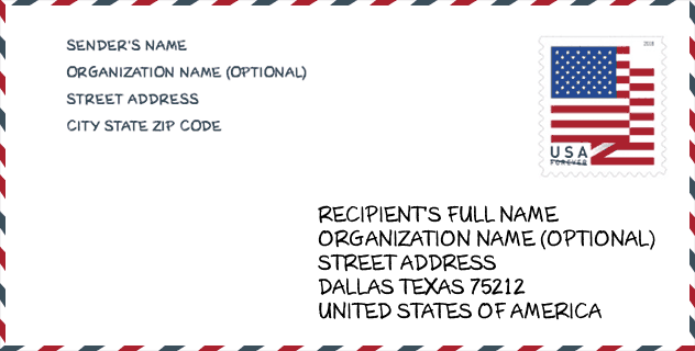
Envelope Example

This is an example of a US zip envelope. You can use a 5-digit zipcode or a detailed 9-digit zipcode to copy the mail in the following address format.
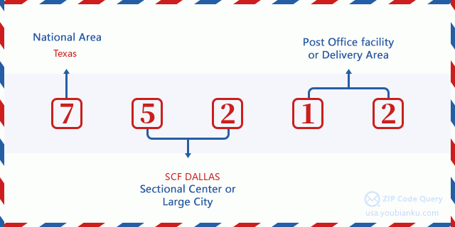
75212 Basic Meaning
What does each digit of ZIP Code 75212 stands for? The first digit designates a national area, which ranges from zero for the Northeast to nine for the far West. The 2-3 digits are the code of a sectional center facility in that region. The last two digits designate small post offices or postal zones.
Online Map

This is online map of the address Dallas, Texas, United States. You may use button to move and zoom in / out. The map information is for reference only.
Library

This is the ZIP Code 75212 - Library page list. Its detail Library Name, Address, City, State, ZIP Code, Phone is as below.
- Name: DALLAS WEST BRANCH LIBRARY
- Address: 2332 SINGLETON BLVD
- City: DALLAS
- State: TX - Texas
- ZIP Code: 75212
- Phone: (214) 670-6445
School

This is the ZIP Code 75212 - School page list. Its detail School Name, Address, City, State, ZIP Code is as below.
| School Name | Address | City | State | Grades | ZIP Code |
|---|---|---|---|---|---|
| UPLIFT HEIGHTS PREPARATORY MIDDLE | 2650 CANADA DR | DALLAS | TX | UG | 75212 |
| UPLIFT HEIGHTS PREPARATORY PRI | 2202 CALYPSO ST | DALLAS | TX | UG | 75212 |
| UPLIFT HEIGHTS PREPARATORY H S | 2650 CANADA DR | DALLAS | TX | UG | 75212 |
| DALLAS COUNTY JUVENILE JUSTICE | 2600 LONE STAR DR STE 5 | DALLAS | TX | UG | 75212 |
| DRC CAMPUS | 1673 TERRE COLONY CT | DALLAS | TX | UG | 75212 |
| DALLAS COUNTY JJAEP CFB CAMPUS | 1673 TERRE COLONY | DALLAS | TX | UG | 75212 |
| DALLAS ENVIRONMENTAL SCIENCE ACADEMY | 3531 N WESTMORELAND RD | DALLAS | TX | UG | 75212 |
| JUVENILE JUSTICE AEP | 1673 TERRE COLONY | DALLAS | TX | UG | 75212 |
| P A S S LEARNING CTR | 1673 TERRE COLONY | DALLAS | TX | UG | 75212 |
| P A S S LEARNING CTR | 1673 TERRE COLONY COURT | DALLAS | TX | UG | 75212 |
| P A S S LEARNING CTR | 1673 TERRY COLONY CT | DALLAS | TX | UG | 75212 |
| DALLAS CO SCHOOL FOR ACCELERATED LRNG | 1673 TERRE COLONY DR | DALLAS | TX | UG | 75212 |
| PASS LEARNING CTR | 1673 TERRE COLONY COURT | DALLAS | TX | UG | 75212 |
Population for ZIP Code 75212

What is the total population in ZIP Code 75212? Below is detail information.
- Population for ZIP Code 75212: 29,242
- 2010 Population: 24,884
The 2020 demographic statistics are in progress. The current population in ZIP code 75212 is 29,242, and the population in 2010 is 24,884.
Gender

In all the statistical population, the male population is 12,349, the female population is 12,535.
- Male Population: 12,349
- Female Population: 12,535
Race

In all the statistical population, the male population is 12,349, the female population is 12,535.
- White Population: 10,209
- Black Population: 7,640
- Hispanic Population: 16,656
- Asian Population: 323
- Hawaiian Population: 48
- Indian Population: 249
- Other Population: 7,295
Age

In all the statistical population, the White population is 10,209, the Black population is 7,640, the Hispanic population is 16,656, the Asian population is 323, the Hawaiian population is 48, the Indian Ppopulation is 249 and Other population is 7,295.
- Age's Median: 27.3
- Median of male age: 26.6
- Median of female age: 28.0
Households for ZIP Code 75212
ZIP code 75212 has 6,796 households, with an average number of 3.62 persons per household. The average income per household in Zip code 75212 is 32,696 USD, and the average house value is 90,700 USD.
- Households Per Zipcode: 6,796
- Persons Per Household: 3.62
- Average House Value: 90,700
- Income Per Household: 32,696
Geographic

The latitude of the Zip code 75212 is 32.775782, the longitude is -96.881774, and the elevation is 430. It has land area of 10.263 square miles, and water area of 0.098 square miles. The time zone for ZIP code 75212 is Central (GMT -06:00). Daylight saving time should be observed in the area where the zip code is located.
- Latitude: 32.775782
- Longitude: -96.881774
- Elevation: 430
- Land Area: 10.263
- Water Area: 0.098
- Time Zone: Central (GMT -06:00)
- Region: South
- Division: West South Central
- Day Light Saving: Y
Congressional District

The Congressional District for ZIP code 75212 is Texas's 30th|33th congressional district, the Congressional Land Area is 356.27|211.94 square mile.
- Congressional District: 30th|33th
- Congressional Land Area: 356.27|211.94
Delivery

In the ZIP code 75212, there are 8,078 residential delivery mailboxes and centralized units, and 937 commercial delivery mailbox and centralized units, 5,611 single family deliveries and 1,948 multifamily deliveries, and the box count is 12,686. The main post office has city delivery carrier routes for the ZIP code 75212.
- Delivery Residential: 8,078
- Delivery Business: 937
- Delivery Total: 12,686
- Single Family Delivery Units: 5,611
- Multi Family Delivery Units: 1,948
- City Delivery Indicator: Y
Business

In ZIP code 75212, the number of business is 437, the number of employee is 11,870, the business first quarter payroll is 129,237,000 USD, the business annual payroll is 529,491,000 USD.
- Number Of Businesses: 437
- Number Of Employees: 11,870
- Business First Quarter Payroll: 129,237,000
- Business Annual Payroll: 529,491,000
Social Security Benefits

There are 3,675 beneficiaries with benefits in current-payment status for ZIP code 75212, of which 2,095 are retired workers, 750 are disabled workers, 300 are widow(er)s and parents, 175 are spouses and 355 are children. The number of beneficiaries aged 65 or older is 2,325. The total monthly benefits are 3,485,000 USD, of which 2,087,000 USD for retired workers, 307,000 USD for widow(er)s and parents.
- Total Number: 3,675
- Retired workers Number: 2,095
- Disabled workers Number: 750
- Widow(er)s and parents Number: 300
- Spouses Number: 175
- Children Number: 355
- All beneficiaries per month: 3,485,000
- Retired workers per month: 2,087,000
- Widow(er)s and parents per month: 307,000
- Number of beneficiaries aged 65 or older: 2,325


Add new comment