ZIP Code: 75235, Dallas, TX
ZIP Code 75235 is located in Dallas, Texas. Its detail State, County, City, Longitude, Latitude, Envelope Example, Population is as below.
ZIP Code 75235 Information

-
-
Country:
U.S. - United States
State:
County FIPS:
48113
County:
City:
City Type ?In many cases, a ZIP Code can have multiple "names", meaning cities, towns, or subdivisions, in its boundaries. However, it will ALWAYS have exactly 1 "default" name. D - Default - This is the "preferred" name - by the USPS - for a city. Each ZIP Code has one - and only one - "default" name. In most cases, this is what people who live in that area call the city as well. A - Acceptable - This name can be used for mailing purposes. Often times alternative names are large neighborhoods or sections of the city/town. In some cases a ZIP Code may have several "acceptable" names which is used to group towns under one ZIP Code. N - Not Acceptable - A "not acceptable" name is, in many cases, a nickname that residents give that location. According to the USPS, you should NOT send mail to that ZIP Code using the "not acceptable" name when mailing.:
D (Default)
ZIP Code:
75235
❓What does D (Default) mean? This is the "preferred" name - by the USPS - for a city. Each ZIP Code has one - and only one - "default" name. In most cases, this is what people who live in that area call the city as well.
ZIP Code 75235 Plus 4
ZIP Code 5 plus 4 is the extension of 5-digit zip code, It can be used to locate a more detailed location. The last four digits designate segment or one side of a street or an apartment. You can find the ZIP+4 code and corresponding address of the zip code 75235 below.
| ZIP Code 5 Plus 4 | Address |
|---|---|
| 75235-0001 | PO BOX 35001, DALLAS, TX |
| 75235-0034 | PO BOX 35034, DALLAS, TX |
| 75235-0041 | PO BOX 35041, DALLAS, TX |
| 75235-0047 | PO BOX 35047, DALLAS, TX |
| 75235-0048 | PO BOX 35048, DALLAS, TX |
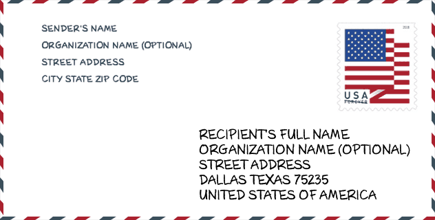
Envelope Example

This is an example of a US zip envelope. You can use a 5-digit zipcode or a detailed 9-digit zipcode to copy the mail in the following address format.
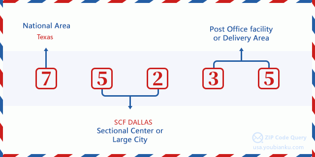
75235 Basic Meaning
What does each digit of ZIP Code 75235 stands for? The first digit designates a national area, which ranges from zero for the Northeast to nine for the far West. The 2-3 digits are the code of a sectional center facility in that region. The last two digits designate small post offices or postal zones.
Online Map

This is online map of the address Dallas, Texas, United States. You may use button to move and zoom in / out. The map information is for reference only.
Hospital

This is the ZIP Code 75235 - Hospital page list. Its detail Hospital Name, Street, City, State, ZIP Code, Phone is as below.
| Name | Address | City | State | ZIP Code | Phone |
|---|---|---|---|---|---|
| PARKLAND HEALTH & HOSPITAL SYSTEM | 5200 HARRY HINES BLVD | DALLAS | TX | 75235 | (214) 590-8000 |
| CHILDRENS MEDICAL CTR OF DALLAS | 1935 MEDICAL DISTRICT DRIVE | DALLAS | TX | 75235 | (214) 456-7000 |
Library

This is the ZIP Code 75235 - Library page list. Its detail Library Name, Address, City, State, ZIP Code, Phone is as below.
- Name: GRAUWYLER PARK BRANCH LIBRARY
- Address: 2146 GILFORD ST
- City: DALLAS
- State: TX - Texas
- ZIP Code: 75235
- Phone: (214) 671-6421
School

This is the ZIP Code 75235 - School page list. Its detail School Name, Address, City, State, ZIP Code is as below.
| School Name | Address | City | State | Grades | ZIP Code |
|---|---|---|---|---|---|
| UPLIFT WILLIAMS PREPARATORY H S | 1750 VICEROY DR | DALLAS | TX | UG | 75235 |
| UPLIFT WILLIAMS PREPARATORY PRI | 1750 VICEROY DR | DALLAS | TX | UG | 75235 |
| UPLIFT WILLIAMS PREPARATORY MIDDLE | 1750 VICEROY DR | DALLAS | TX | UG | 75235 |
| CALLIER CENTER PRE-SCHOOL DEAF (0-5) | 1966 INWOOD RD | DALLAS | TX | UG | 75235 |
| ARLINGTON PARK EARLY CHILDHOOD CENTER | 5606 WAYSIDE DR | DALLAS | TX | UG | 75235 |
| MONTESSORI ACADEMY AT ONESIMO HERNANDEZ EL | 5555 MAPLE AVE | DALLAS | TX | UG | 75235 |
| P A S S LEARNING CTR | 1673 TERRE COLONY COURT | DALLAS | TX | UG | 75235 |
Population for ZIP Code 75235

What is the total population in ZIP Code 75235? Below is detail information.
- Population for ZIP Code 75235: 23,000
- 2010 Population: 17,177
The 2020 demographic statistics are in progress. The current population in ZIP code 75235 is 23,000, and the population in 2010 is 17,177.
Gender

In all the statistical population, the male population is 9,501, the female population is 7,676.
- Male Population: 9,501
- Female Population: 7,676
Race

In all the statistical population, the male population is 9,501, the female population is 7,676.
- White Population: 10,304
- Black Population: 2,092
- Hispanic Population: 11,310
- Asian Population: 1,046
- Hawaiian Population: 28
- Indian Population: 196
- Other Population: 4,054
Age

In all the statistical population, the White population is 10,304, the Black population is 2,092, the Hispanic population is 11,310, the Asian population is 1,046, the Hawaiian population is 28, the Indian Ppopulation is 196 and Other population is 4,054.
- Age's Median: 30.9
- Median of male age: 31.8
- Median of female age: 29.8
Households for ZIP Code 75235
ZIP code 75235 has 6,295 households, with an average number of 2.62 persons per household. The average income per household in Zip code 75235 is 49,294 USD, and the average house value is 134,600 USD.
- Households Per Zipcode: 6,295
- Persons Per Household: 2.62
- Average House Value: 134,600
- Income Per Household: 49,294
Geographic

The latitude of the Zip code 75235 is 32.831295, the longitude is -96.845969, and the elevation is 453. It has land area of 6.72 square miles, and water area of 0.199 square miles. The time zone for ZIP code 75235 is Central (GMT -06:00). Daylight saving time should be observed in the area where the zip code is located.
- Latitude: 32.831295
- Longitude: -96.845969
- Elevation: 453
- Land Area: 6.72
- Water Area: 0.199
- Time Zone: Central (GMT -06:00)
- Region: South
- Division: West South Central
- Day Light Saving: Y
Congressional District

The Congressional District for ZIP code 75235 is Texas's 30th|32th|33th congressional district, the Congressional Land Area is 356.27|185.66|211.94 square mile.
- Congressional District: 30th|32th|33th
- Congressional Land Area: 356.27|185.66|211.94
Delivery

In the ZIP code 75235, there are 8,779 residential delivery mailboxes and centralized units, and 1,131 commercial delivery mailbox and centralized units, 2,590 single family deliveries and 5,993 multifamily deliveries, and the box count is 10,588. The main post office has city delivery carrier routes for the ZIP code 75235.
- Delivery Residential: 8,779
- Delivery Business: 1,131
- Delivery Total: 10,588
- Single Family Delivery Units: 2,590
- Multi Family Delivery Units: 5,993
- City Delivery Indicator: Y
Business

In ZIP code 75235, the number of business is 651, the number of employee is 36,563, the business first quarter payroll is 682,127,000 USD, the business annual payroll is 2,526,508,000 USD.
- Number Of Businesses: 651
- Number Of Employees: 36,563
- Business First Quarter Payroll: 682,127,000
- Business Annual Payroll: 2,526,508,000
Social Security Benefits

There are 1,845 beneficiaries with benefits in current-payment status for ZIP code 75235, of which 1,200 are retired workers, 360 are disabled workers, 95 are widow(er)s and parents, 70 are spouses and 120 are children. The number of beneficiaries aged 65 or older is 1,280. The total monthly benefits are 2,191,000 USD, of which 1,523,000 USD for retired workers, 109,000 USD for widow(er)s and parents.
- Total Number: 1,845
- Retired workers Number: 1,200
- Disabled workers Number: 360
- Widow(er)s and parents Number: 95
- Spouses Number: 70
- Children Number: 120
- All beneficiaries per month: 2,191,000
- Retired workers per month: 1,523,000
- Widow(er)s and parents per month: 109,000
- Number of beneficiaries aged 65 or older: 1,280


Add new comment