United States ZIP Code: 75652
This is the Texas ZIP Code 75652 page list. Its detail State, County, City, Longitude, Latitude, Envelope Example, Population is as below.
ZIP Code 75652 Information

-
-
Country:
U.S. - United States
State:
State FIPS:
48
ZIP Code:
75652
ZIP Type:
S (Standard)
❓What does S (Standard) mean? A "standard" ZIP Code is what most people think of when they talk about ZIP Codes - essentially a town, city, or a division of a city that has mail service.
ZIP Code 75652 - City

This is the city information corresponding to 75652:
| State | County | City | City Type ?In many cases, a ZIP Code can have multiple "names", meaning cities, towns, or subdivisions, in its boundaries. However, it will ALWAYS have exactly 1 "default" name. D - Default - This is the "preferred" name - by the USPS - for a city. Each ZIP Code has one - and only one - "default" name. In most cases, this is what people who live in that area call the city as well. A - Acceptable - This name can be used for mailing purposes. Often times alternative names are large neighborhoods or sections of the city/town. In some cases a ZIP Code may have several "acceptable" names which is used to group towns under one ZIP Code. N - Not Acceptable - A "not acceptable" name is, in many cases, a nickname that residents give that location. According to the USPS, you should NOT send mail to that ZIP Code using the "not acceptable" name when mailing. | ZIP Code |
|---|---|---|---|---|
| TX | Rusk | Chapman | N (Not Acceptable) | 75652 |
| TX | Rusk | Church Hill | N (Not Acceptable) | 75652 |
| TX | Rusk | Craig | N (Not Acceptable) | 75652 |
| TX | Rusk | Crimcrest | N (Not Acceptable) | 75652 |
| TX | Rusk | Good Springs | N (Not Acceptable) | 75652 |
| TX | Rusk | Henderson | D (Default) | 75652 |
| TX | Rusk | Lake Cherokee | N (Not Acceptable) | 75652 |
| TX | Rusk | Mcknight | N (Not Acceptable) | 75652 |
| TX | Rusk | New Salem | N (Not Acceptable) | 75652 |
| TX | Rusk | Pinehill | N (Not Acceptable) | 75652 |
| TX | Rusk | Pleasant Grove | N (Not Acceptable) | 75652 |
| TX | Rusk | Stewart | N (Not Acceptable) | 75652 |
❓What does D (Default) mean? This is the "preferred" name - by the USPS - for a city. Each ZIP Code has one - and only one - "default" name. In most cases, this is what people who live in that area call the city as well.
❓What does N (Not Acceptable) mean? A "not acceptable" name is, in many cases, a nickname that residents give that location. According to the USPS, you should NOT send mail to that ZIP Code using the "not acceptable" name when mailing.
ZIP Code 75652 Plus 4
ZIP Code 5 plus 4 is the extension of 5-digit zip code, It can be used to locate a more detailed location. The last four digits designate segment or one side of a street or an apartment. You can find the ZIP+4 code and corresponding address of the zip code 75652 below.
| ZIP Code 5 Plus 4 | Address |
|---|---|
| 75652-2200 | 2500 US HIGHWAY 79, HENDERSON, TX |
| 75652-2202 | 2600 US HIGHWAY 79, HENDERSON, TX |
| 75652-2204 | 2700 US HIGHWAY 79, HENDERSON, TX |
| 75652-2206 | 2800 US HIGHWAY 79, HENDERSON, TX |
| 75652-2208 | 2900 US HIGHWAY 79, HENDERSON, TX |
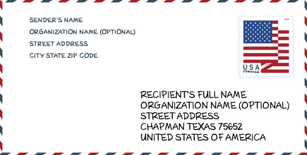
Envelope Example

This is an example of a US zip envelope. You can use a 5-digit zipcode or a detailed 9-digit zipcode to copy the mail in the following address format.
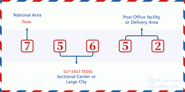
75652 Basic Meaning
What does each digit of ZIP Code 75652 stands for? The first digit designates a national area, which ranges from zero for the Northeast to nine for the far West. The 2-3 digits are the code of a sectional center facility in that region. The last two digits designate small post offices or postal zones.
Online Map

This is online map of the address Stewart, Texas, United States. You may use button to move and zoom in / out. The map information is for reference only.
Hospital

This is the ZIP Code 75652 - Hospital page list. Its detail Hospital Name, Street, City, State, ZIP Code, Phone is as below.
- Name: UT HEALTH EAST TEXAS HENDERSON HOSPITAL
- Address: HENDERSON
- City: 300 WILSON STREET
- State: TX
- ZIP Code: 75652
- Phone: (903) 657-7541
Library

This is the ZIP Code 75652 - Library page list. Its detail Library Name, Address, City, State, ZIP Code, Phone is as below.
| Name | Address | City | State | ZIP Code | Phone |
|---|---|---|---|---|---|
| RUSK COUNTY LIBRARY | 106 E MAIN ST | HENDERSON | TX | 75652 | (903) 657-8557 |
| RUSK COUNTY LIBRARY SYSTEM | 106 E MAIN ST | HENDERSON | TX | 75652 | (903) 657-8557 |
School

This is the ZIP Code 75652 - School page list. Its detail School Name, Address, City, State, ZIP Code is as below.
- School Name: HENDERSON H S
- Address: 1900 HWY 64
- City: HENDERSON
- State: TX
- Grades: UG
- ZIP Code: 75652
Population for ZIP Code 75652

What is the total population in ZIP Code 75652? Below is detail information.
- Population for ZIP Code 75652: 13,384
- 2010 Population: 16,638
The 2020 demographic statistics are in progress. The current population in ZIP code 75652 is 13,384, and the population in 2010 is 16,638.
Gender

In all the statistical population, the male population is 9,856, the female population is 6,782.
- Male Population: 9,856
- Female Population: 6,782
Race

In all the statistical population, the male population is 9,856, the female population is 6,782.
- White Population: 10,923
- Black Population: 4,579
- Hispanic Population: 2,323
- Asian Population: 77
- Hawaiian Population: 13
- Indian Population: 145
- Other Population: 1,168
Age

In all the statistical population, the White population is 10,923, the Black population is 4,579, the Hispanic population is 2,323, the Asian population is 77, the Hawaiian population is 13, the Indian Ppopulation is 145 and Other population is 1,168.
- Age's Median: 38.0
- Median of male age: 36.4
- Median of female age: 40.7
Households for ZIP Code 75652
ZIP code 75652 has 4,811 households, with an average number of 2.57 persons per household. The average income per household in Zip code 75652 is 48,526 USD, and the average house value is 145,100 USD.
- Households Per Zipcode: 4,811
- Persons Per Household: 2.57
- Average House Value: 145,100
- Income Per Household: 48,526
Geographic

The latitude of the Zip code 75652 is 32.257221, the longitude is -94.738400, and the elevation is 399. It has land area of 175.71 square miles, and water area of 4.324 square miles. The time zone for ZIP code 75652 is Central (GMT -06:00). Daylight saving time should be observed in the area where the zip code is located.
- Latitude: 32.257221
- Longitude: -94.738400
- Elevation: 399
- Land Area: 175.71
- Water Area: 4.324
- Time Zone: Central (GMT -06:00)
- Region: South
- Division: West South Central
- Day Light Saving: Y
Congressional District

The Congressional District for ZIP code 75652 is Texas's 1st congressional district, the Congressional Land Area is 7858.86 square mile.
- Congressional District: 1st
- Congressional Land Area: 7858.86
Delivery

In the ZIP code 75652, there are 5,208 residential delivery mailboxes and centralized units, and 444 commercial delivery mailbox and centralized units, 4,812 single family deliveries and 326 multifamily deliveries, and the box count is 5,652. The main post office has city delivery carrier routes for the ZIP code 75652.
- Delivery Residential: 5,208
- Delivery Business: 444
- Delivery Total: 5,652
- Single Family Delivery Units: 4,812
- Multi Family Delivery Units: 326
- City Delivery Indicator: Y
Business

In ZIP code 75652, the number of business is 318, the number of employee is 4,575, the business first quarter payroll is 46,305,000 USD, the business annual payroll is 207,239,000 USD.
- Number Of Businesses: 318
- Number Of Employees: 4,575
- Business First Quarter Payroll: 46,305,000
- Business Annual Payroll: 207,239,000
Social Security Benefits

There are 2,780 beneficiaries with benefits in current-payment status for ZIP code 75652, of which 1,840 are retired workers, 375 are disabled workers, 250 are widow(er)s and parents, 120 are spouses and 195 are children. The number of beneficiaries aged 65 or older is 2,020. The total monthly benefits are 3,668,000 USD, of which 2,665,000 USD for retired workers, 328,000 USD for widow(er)s and parents.
- Total Number: 2,780
- Retired workers Number: 1,840
- Disabled workers Number: 375
- Widow(er)s and parents Number: 250
- Spouses Number: 120
- Children Number: 195
- All beneficiaries per month: 3,668,000
- Retired workers per month: 2,665,000
- Widow(er)s and parents per month: 328,000
- Number of beneficiaries aged 65 or older: 2,020


Add new comment