United States ZIP Code: 76120
This is the Texas ZIP Code 76120 page list. Its detail State, County, City, Longitude, Latitude, Envelope Example, Population is as below.
ZIP Code 76120 Information

-
-
Country:
U.S. - United States
State:
State FIPS:
48
ZIP Code:
76120
ZIP Type:
S (Standard)
❓What does S (Standard) mean? A "standard" ZIP Code is what most people think of when they talk about ZIP Codes - essentially a town, city, or a division of a city that has mail service.
ZIP Code 76120 - City

This is the city information corresponding to 76120:
| State | County | City | City Type ?In many cases, a ZIP Code can have multiple "names", meaning cities, towns, or subdivisions, in its boundaries. However, it will ALWAYS have exactly 1 "default" name. D - Default - This is the "preferred" name - by the USPS - for a city. Each ZIP Code has one - and only one - "default" name. In most cases, this is what people who live in that area call the city as well. A - Acceptable - This name can be used for mailing purposes. Often times alternative names are large neighborhoods or sections of the city/town. In some cases a ZIP Code may have several "acceptable" names which is used to group towns under one ZIP Code. N - Not Acceptable - A "not acceptable" name is, in many cases, a nickname that residents give that location. According to the USPS, you should NOT send mail to that ZIP Code using the "not acceptable" name when mailing. | ZIP Code |
|---|---|---|---|---|
| TX | Tarrant | Fort Worth | D (Default) | 76120 |
| TX | Tarrant | Ft Worth | A (Acceptable) | 76120 |
❓What does D (Default) mean? This is the "preferred" name - by the USPS - for a city. Each ZIP Code has one - and only one - "default" name. In most cases, this is what people who live in that area call the city as well.
❓What does A (Acceptable) mean? This name can be used for mailing purposes. Often times alternative names are large neighborhoods or sections of the city/town. In some cases a ZIP Code may have several "acceptable" names which is used to group towns under one ZIP Code.
ZIP Code 76120 Plus 4
ZIP Code 5 plus 4 is the extension of 5-digit zip code, It can be used to locate a more detailed location. The last four digits designate segment or one side of a street or an apartment. You can find the ZIP+4 code and corresponding address of the zip code 76120 below.
| ZIP Code 5 Plus 4 | Address |
|---|---|
| 76120-0600 | 730 ADOLPHUS CIR, FORT WORTH, TX |
| 76120-0601 | 730 ADOLPHUS CIR #00002601 , FORT WORTH, TX |
| 76120-0602 | 812 MEDICAL DR, FORT WORTH, TX |
| 76120-0603 | 812 MEDICAL DR #00002701 , FORT WORTH, TX |
| 76120-0604 | 800 MEDICAL DR, FORT WORTH, TX |
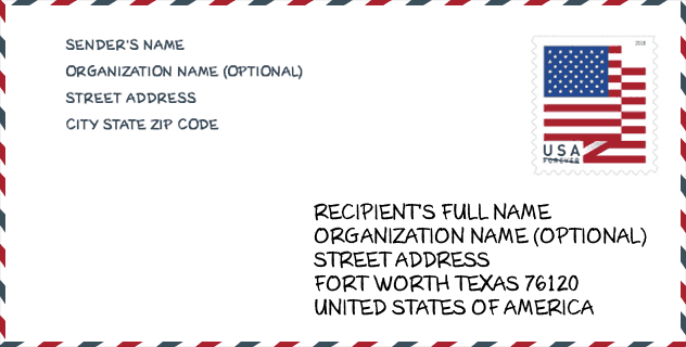
Envelope Example

This is an example of a US zip envelope. You can use a 5-digit zipcode or a detailed 9-digit zipcode to copy the mail in the following address format.
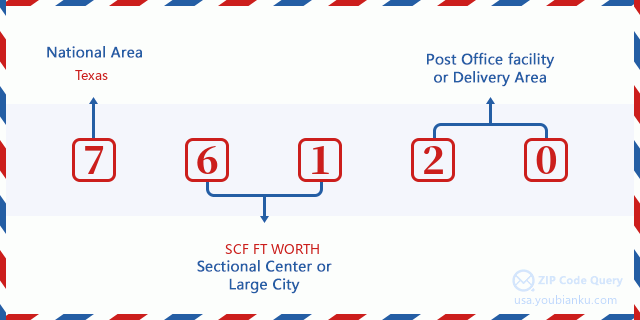
76120 Basic Meaning
What does each digit of ZIP Code 76120 stands for? The first digit designates a national area, which ranges from zero for the Northeast to nine for the far West. The 2-3 digits are the code of a sectional center facility in that region. The last two digits designate small post offices or postal zones.
Online Map

This is online map of the address Ft Worth, Texas, United States. You may use button to move and zoom in / out. The map information is for reference only.
School

This is the ZIP Code 76120 - School page list. Its detail School Name, Address, City, State, ZIP Code is as below.
| School Name | Address | City | State | Grades | ZIP Code |
|---|---|---|---|---|---|
| UPLIFT CRESCENDO PREPARATORY PRI | 1200 COOKS LN | FORT WORTH | TX | UG | 76120 |
| IGNITE COMMUNITY SCHOOL-FORT WORTH | 8601 RANDOL MILL RD | FORT WORTH | TX | UG | 76120 |
| LOWERY ROAD | 7600 LOWERY RD | FORT WORTH | TX | UG | 76120 |
| JOHN T WHITE EL | 7300 JOHN T WHITE RD | FORT WORTH | TX | UG | 76120 |
Population for ZIP Code 76120

What is the total population in ZIP Code 76120? Below is detail information.
- Population for ZIP Code 76120: 19,117
- 2010 Population: 15,283
The 2020 demographic statistics are in progress. The current population in ZIP code 76120 is 19,117, and the population in 2010 is 15,283.
Gender

In all the statistical population, the male population is 7,069, the female population is 8,214.
- Male Population: 7,069
- Female Population: 8,214
Race

In all the statistical population, the male population is 7,069, the female population is 8,214.
- White Population: 6,589
- Black Population: 7,064
- Hispanic Population: 2,614
- Asian Population: 728
- Hawaiian Population: 22
- Indian Population: 165
- Other Population: 1,252
Age

In all the statistical population, the White population is 6,589, the Black population is 7,064, the Hispanic population is 2,614, the Asian population is 728, the Hawaiian population is 22, the Indian Ppopulation is 165 and Other population is 1,252.
- Age's Median: 30.6
- Median of male age: 30.0
- Median of female age: 31.1
Households for ZIP Code 76120
ZIP code 76120 has 6,608 households, with an average number of 2.31 persons per household. The average income per household in Zip code 76120 is 50,663 USD, and the average house value is 149,900 USD.
- Households Per Zipcode: 6,608
- Persons Per Household: 2.31
- Average House Value: 149,900
- Income Per Household: 50,663
Geographic

The latitude of the Zip code 76120 is 32.763098, the longitude is -97.181401, and the elevation is 602. It has land area of 9.771 square miles, and water area of 0.45 square miles. The time zone for ZIP code 76120 is Central (GMT -06:00). Daylight saving time should be observed in the area where the zip code is located.
- Latitude: 32.763098
- Longitude: -97.181401
- Elevation: 602
- Land Area: 9.771
- Water Area: 0.45
- Time Zone: Central (GMT -06:00)
- Region: South
- Division: West South Central
- Day Light Saving: Y
Congressional District

The Congressional District for ZIP code 76120 is Texas's 06th|24th|33th congressional district, the Congressional Land Area is 2148.41|262.76|211.94 square mile.
- Congressional District: 06th|24th|33th
- Congressional Land Area: 2148.41|262.76|211.94
Delivery

In the ZIP code 76120, there are 8,276 residential delivery mailboxes and centralized units, and 208 commercial delivery mailbox and centralized units, 2,821 single family deliveries and 4,416 multifamily deliveries, and the box count is 10,391. The main post office has city delivery carrier routes for the ZIP code 76120.
- Delivery Residential: 8,276
- Delivery Business: 208
- Delivery Total: 10,391
- Single Family Delivery Units: 2,821
- Multi Family Delivery Units: 4,416
- City Delivery Indicator: Y
Business

In ZIP code 76120, the number of business is 198, the number of employee is 4,429, the business first quarter payroll is 25,621,000 USD, the business annual payroll is 105,359,000 USD.
- Number Of Businesses: 198
- Number Of Employees: 4,429
- Business First Quarter Payroll: 25,621,000
- Business Annual Payroll: 105,359,000
Social Security Benefits

There are 2,080 beneficiaries with benefits in current-payment status for ZIP code 76120, of which 1,295 are retired workers, 395 are disabled workers, 130 are widow(er)s and parents, 60 are spouses and 200 are children. The number of beneficiaries aged 65 or older is 1,375. The total monthly benefits are 2,652,000 USD, of which 1,850,000 USD for retired workers, 161,000 USD for widow(er)s and parents.
- Total Number: 2,080
- Retired workers Number: 1,295
- Disabled workers Number: 395
- Widow(er)s and parents Number: 130
- Spouses Number: 60
- Children Number: 200
- All beneficiaries per month: 2,652,000
- Retired workers per month: 1,850,000
- Widow(er)s and parents per month: 161,000
- Number of beneficiaries aged 65 or older: 1,375


Add new comment