ZIP Code: 77092, Houston, TX
ZIP Code 77092 is located in Houston, Texas. Its detail State, County, City, Longitude, Latitude, Envelope Example, Population is as below.
ZIP Code 77092 Information

-
-
Country:
U.S. - United States
State:
County FIPS:
48201
County:
City:
City Type ?In many cases, a ZIP Code can have multiple "names", meaning cities, towns, or subdivisions, in its boundaries. However, it will ALWAYS have exactly 1 "default" name. D - Default - This is the "preferred" name - by the USPS - for a city. Each ZIP Code has one - and only one - "default" name. In most cases, this is what people who live in that area call the city as well. A - Acceptable - This name can be used for mailing purposes. Often times alternative names are large neighborhoods or sections of the city/town. In some cases a ZIP Code may have several "acceptable" names which is used to group towns under one ZIP Code. N - Not Acceptable - A "not acceptable" name is, in many cases, a nickname that residents give that location. According to the USPS, you should NOT send mail to that ZIP Code using the "not acceptable" name when mailing.:
D (Default)
ZIP Code:
77092
❓What does D (Default) mean? This is the "preferred" name - by the USPS - for a city. Each ZIP Code has one - and only one - "default" name. In most cases, this is what people who live in that area call the city as well.
ZIP Code 77092 Plus 4
ZIP Code 5 plus 4 is the extension of 5-digit zip code, It can be used to locate a more detailed location. The last four digits designate segment or one side of a street or an apartment. You can find the ZIP+4 code and corresponding address of the zip code 77092 below.
| ZIP Code 5 Plus 4 | Address |
|---|---|
| 77092-0001 | 19301 SUNTANTI DR, HOUSTON, TX |
| 77092-1001 | 6801 PINE VISTA LN, HOUSTON, TX |
| 77092-1002 | 6800 PINE VISTA LN, HOUSTON, TX |
| 77092-1003 | 6101 BLACK GUM DR, HOUSTON, TX |
| 77092-1004 | 6100 BLACK GUM DR, HOUSTON, TX |
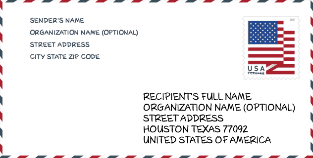
Envelope Example

This is an example of a US zip envelope. You can use a 5-digit zipcode or a detailed 9-digit zipcode to copy the mail in the following address format.
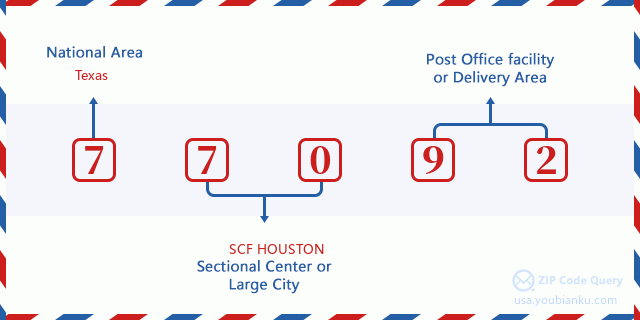
77092 Basic Meaning
What does each digit of ZIP Code 77092 stands for? The first digit designates a national area, which ranges from zero for the Northeast to nine for the far West. The 2-3 digits are the code of a sectional center facility in that region. The last two digits designate small post offices or postal zones.
Online Map

This is online map of the address Houston, Texas, United States. You may use button to move and zoom in / out. The map information is for reference only.
University

This is the ZIP Code 77092 - University page list. Its detail university Name, Street, City, State, ZIP Code, Phone is as below.
| Name | Street | City | State | ZIP Code | Phone |
| College of Health Care Professions-Northwest | 240 Northwest Mall | Houston | TX | 77092 | - |
| Northwest Educational Center | 2910 Antoine B-100 | Houston | TX | 77092 | (713) 680-2929 x2369 |
| The College of Health Care Professions-Northwest | 12230 Northwest Freeway | Houston | TX | 77092 | (713) 425-3100 |
Museum

This is the ZIP Code 77092 - Museum page list. Its detail Museum Name, Street, City, State, ZIP Code, Phone is as below.
- Name: SOUTHERN APACHE MUSEUM
- Street: 550 NORTHWEST MALL
- City: HOUSTON
- State: TX
- ZIP Code: 77092
- Phone: (281) 686-1462
Library

This is the ZIP Code 77092 - Library page list. Its detail Library Name, Address, City, State, ZIP Code, Phone is as below.
- Name: COLLIER REGIONAL LIBRARY
- Address: 6200 PINEMONT DR
- City: HOUSTON
- State: TX - Texas
- ZIP Code: 77092
- Phone: (832) 393-1740
School
This is the ZIP Code 77092 - School page list. Its detail School Name, Address, City, State, ZIP Code is as below.
| School Name | Address | City | State | Grades | ZIP Code |
|---|---|---|---|---|---|
| SOUTHWEST SCHOOLS MANGUM EL CAMPUS | 4515 MANGUM RD | HOUSTON | TX | UG | 77092 |
| KIPP NEXUS PRI | 4211 WATONGA BLVD | HOUSTON | TX | UG | 77092 |
| KIPP NEXUS MIDDLE | 4211 WATONGA BLVD | HOUSTON | TX | UG | 77092 |
Population for ZIP Code 77092

What is the total population in ZIP Code 77092? Below is detail information.
- Population for ZIP Code 77092: 38,458
- 2010 Population: 33,745
The 2020 demographic statistics are in progress. The current population in ZIP code 77092 is 38,458, and the population in 2010 is 33,745.
Gender

In all the statistical population, the male population is 17,174, the female population is 16,571.
- Male Population: 17,174
- Female Population: 16,571
Race

In all the statistical population, the male population is 17,174, the female population is 16,571.
- White Population: 20,961
- Black Population: 4,802
- Hispanic Population: 19,605
- Asian Population: 513
- Hawaiian Population: 37
- Indian Population: 419
- Other Population: 8,167
Age

In all the statistical population, the White population is 20,961, the Black population is 4,802, the Hispanic population is 19,605, the Asian population is 513, the Hawaiian population is 37, the Indian Ppopulation is 419 and Other population is 8,167.
- Age's Median: 32.1
- Median of male age: 31.4
- Median of female age: 33.0
Households for ZIP Code 77092
ZIP code 77092 has 12,654 households, with an average number of 2.66 persons per household. The average income per household in Zip code 77092 is 40,521 USD, and the average house value is 166,100 USD.
- Households Per Zipcode: 12,654
- Persons Per Household: 2.66
- Average House Value: 166,100
- Income Per Household: 40,521
Geographic

The latitude of the Zip code 77092 is 29.830050, the longitude is -95.467548, and the elevation is 67. It has land area of 7.604 square miles, and water area of 0.016 square miles. The time zone for ZIP code 77092 is Central (GMT -06:00). Daylight saving time should be observed in the area where the zip code is located.
- Latitude: 29.830050
- Longitude: -95.467548
- Elevation: 67
- Land Area: 7.604
- Water Area: 0.016
- Time Zone: Central (GMT -06:00)
- Region: South
- Division: West South Central
- Day Light Saving: Y
Congressional District

The Congressional District for ZIP code 77092 is Texas's 2nd|18th congressional district, the Congressional Land Area is 308.75|235.2 square mile.
- Congressional District: 2nd|18th
- Congressional Land Area: 308.75|235.2
Delivery

In the ZIP code 77092, there are 14,458 residential delivery mailboxes and centralized units, and 3,157 commercial delivery mailbox and centralized units, 5,851 single family deliveries and 7,905 multifamily deliveries, and the box count is 16,949. The main post office has city delivery carrier routes for the ZIP code 77092.
- Delivery Residential: 14,458
- Delivery Business: 3,157
- Delivery Total: 16,949
- Single Family Delivery Units: 5,851
- Multi Family Delivery Units: 7,905
- City Delivery Indicator: Y
Business

In ZIP code 77092, the number of business is 1,458, the number of employee is 27,554, the business first quarter payroll is 320,700,000 USD, the business annual payroll is 1,270,127,000 USD.
- Number Of Businesses: 1,458
- Number Of Employees: 27,554
- Business First Quarter Payroll: 320,700,000
- Business Annual Payroll: 1,270,127,000
Social Security Benefits

There are 3,990 beneficiaries with benefits in current-payment status for ZIP code 77092, of which 2,850 are retired workers, 485 are disabled workers, 275 are widow(er)s and parents, 170 are spouses and 210 are children. The number of beneficiaries aged 65 or older is 3,110. The total monthly benefits are 5,407,000 USD, of which 4,159,000 USD for retired workers, 381,000 USD for widow(er)s and parents.
- Total Number: 3,990
- Retired workers Number: 2,850
- Disabled workers Number: 485
- Widow(er)s and parents Number: 275
- Spouses Number: 170
- Children Number: 210
- All beneficiaries per month: 5,407,000
- Retired workers per month: 4,159,000
- Widow(er)s and parents per month: 381,000
- Number of beneficiaries aged 65 or older: 3,110


Add new comment