ZIP Code: 77642, Port Arthur, TX
ZIP Code 77642 is located in Port Arthur, Texas. Its detail State, County, City, Longitude, Latitude, Envelope Example, Population is as below.
ZIP Code 77642 Information

-
-
Country:
U.S. - United States
State:
County FIPS:
48245
City:
Area Code:
City Type ?In many cases, a ZIP Code can have multiple "names", meaning cities, towns, or subdivisions, in its boundaries. However, it will ALWAYS have exactly 1 "default" name. D - Default - This is the "preferred" name - by the USPS - for a city. Each ZIP Code has one - and only one - "default" name. In most cases, this is what people who live in that area call the city as well. A - Acceptable - This name can be used for mailing purposes. Often times alternative names are large neighborhoods or sections of the city/town. In some cases a ZIP Code may have several "acceptable" names which is used to group towns under one ZIP Code. N - Not Acceptable - A "not acceptable" name is, in many cases, a nickname that residents give that location. According to the USPS, you should NOT send mail to that ZIP Code using the "not acceptable" name when mailing.:
D (Default)
ZIP Code:
77642
❓What does D (Default) mean? This is the "preferred" name - by the USPS - for a city. Each ZIP Code has one - and only one - "default" name. In most cases, this is what people who live in that area call the city as well.
ZIP Code 77642 Plus 4
ZIP Code 5 plus 4 is the extension of 5-digit zip code, It can be used to locate a more detailed location. The last four digits designate segment or one side of a street or an apartment. You can find the ZIP+4 code and corresponding address of the zip code 77642 below.
| ZIP Code 5 Plus 4 | Address |
|---|---|
| 77642-0100 | 3901 GRANDVIEW AVE, PORT ARTHUR, TX |
| 77642-0101 | 3700 LOCUST AVE, PORT ARTHUR, TX |
| 77642-0102 | 3701 LOCUST AVE, PORT ARTHUR, TX |
| 77642-0103 | 3800 LOCUST AVE, PORT ARTHUR, TX |
| 77642-0104 | 3801 LOCUST AVE, PORT ARTHUR, TX |
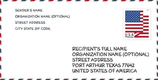
Envelope Example

This is an example of a US zip envelope. You can use a 5-digit zipcode or a detailed 9-digit zipcode to copy the mail in the following address format.
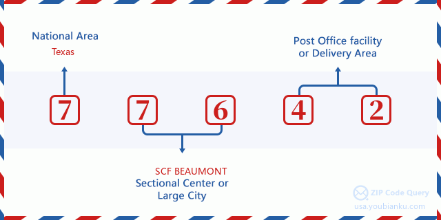
77642 Basic Meaning
What does each digit of ZIP Code 77642 stands for? The first digit designates a national area, which ranges from zero for the Northeast to nine for the far West. The 2-3 digits are the code of a sectional center facility in that region. The last two digits designate small post offices or postal zones.
Online Map

This is online map of the address Port Arthur, Texas, United States. You may use button to move and zoom in / out. The map information is for reference only.
Museum

This is the ZIP Code 77642 - Museum page list. Its detail Museum Name, Street, City, State, ZIP Code, Phone is as below.
- Name: TEXAS ARTISTS MUSEUM SOCIETY
- Street: 3501 CULTURAL CENTER DR
- City: PORT ARTHUR
- State: TX
- ZIP Code: 77642
- Phone:
Library

This is the ZIP Code 77642 - Library page list. Its detail Library Name, Address, City, State, ZIP Code, Phone is as below.
- Name: PORT ARTHUR PUBLIC LIBRARY
- Address: 4615 9TH AVE
- City: PORT ARTHUR
- State: TX - Texas
- ZIP Code: 77642
- Phone: (409) 985-8838
School

This is the ZIP Code 77642 - School page list. Its detail School Name, Address, City, State, ZIP Code is as below.
| School Name | Address | City | State | Grades | ZIP Code |
|---|---|---|---|---|---|
| TEKOA ACADEMY OF ACCELERATED STUDIES | 3700 PROCTOR | PORT ARTHUR | TX | UG | 77642 |
| BOB HOPE SCHOOL | 2849 9TH AVE | PORT ARTHUR | TX | UG | 77642 |
| BOB HOPE SCHOOL - EL CAMPUS | 4301 32ND ST | PORT ARTHUR | TX | UG | 77642 |
| BOB HOPE H S | 4545 HWY 73 | PORT ARTHUR | TX | UG | 77642 |
| PORT ACRES EL | 5900 JADE AVE | PORT ARTHUR | TX | UG | 77642 |
| JEFFERSON MIDDLE | 2200 JEFFERSON DR | PORT ARTHUR | TX | UG | 77642 |
| LAKEVIEW EL | 3900 10TH ST | PORT ARTHUR | TX | UG | 77642 |
| WHEATLEY SCHOOL OF EARLY CHILDHOOD PROGRAMS | 1100 JEFFERSON DR | PORT ARTHUR | TX | UG | 77642 |
| STILWELL TECH CTR/CATE | 3501 SGT LUCIAN ADAMS DR | PORT ARTHUR | TX | UG | 77642 |
| MEMORIAL H S | 3501 SSGT LUCIAN ADAM DR | PORT ARTHUR | TX | UG | 77642 |
| STAFF SERGEANT LUCIAN ADAMS EL | 5701 9TH AVE | PORT ARTHUR | TX | UG | 77642 |
| WEST GROVES EARLY LEARNING CENTER | 5856 9TH AVE | PORT ARTHUR | TX | UG | 77642 |
Population for ZIP Code 77642

What is the total population in ZIP Code 77642? Below is detail information.
- Population for ZIP Code 77642: 40,533
- 2010 Population: 37,111
The 2020 demographic statistics are in progress. The current population in ZIP code 77642 is 40,533, and the population in 2010 is 37,111.
Gender

In all the statistical population, the male population is 18,260, the female population is 18,851.
- Male Population: 18,260
- Female Population: 18,851
Race

In all the statistical population, the male population is 18,260, the female population is 18,851.
- White Population: 15,320
- Black Population: 12,155
- Hispanic Population: 13,763
- Asian Population: 3,156
- Hawaiian Population: 40
- Indian Population: 496
- Other Population: 7,063
Age

In all the statistical population, the White population is 15,320, the Black population is 12,155, the Hispanic population is 13,763, the Asian population is 3,156, the Hawaiian population is 40, the Indian Ppopulation is 496 and Other population is 7,063.
- Age's Median: 32.6
- Median of male age: 31.5
- Median of female age: 33.9
Households for ZIP Code 77642
ZIP code 77642 has 13,451 households, with an average number of 2.71 persons per household. The average income per household in Zip code 77642 is 34,736 USD, and the average house value is 64,200 USD.
- Households Per Zipcode: 13,451
- Persons Per Household: 2.71
- Average House Value: 64,200
- Income Per Household: 34,736
Geographic

The latitude of the Zip code 77642 is 29.912176, the longitude is -93.916448, and the elevation is 8. It has land area of 19.687 square miles, and water area of 1.83 square miles. The time zone for ZIP code 77642 is Central (GMT -06:00). Daylight saving time should be observed in the area where the zip code is located.
- Latitude: 29.912176
- Longitude: -93.916448
- Elevation: 8
- Land Area: 19.687
- Water Area: 1.83
- Time Zone: Central (GMT -06:00)
- Region: South
- Division: West South Central
- Day Light Saving: Y
Congressional District

The Congressional District for ZIP code 77642 is Texas's 14th congressional district, the Congressional Land Area is 2441.39 square mile.
- Congressional District: 14th
- Congressional Land Area: 2441.39
Delivery

In the ZIP code 77642, there are 14,957 residential delivery mailboxes and centralized units, and 961 commercial delivery mailbox and centralized units, 9,363 single family deliveries and 4,121 multifamily deliveries, and the box count is 15,888. The main post office has city delivery carrier routes for the ZIP code 77642.
- Delivery Residential: 14,957
- Delivery Business: 961
- Delivery Total: 15,888
- Single Family Delivery Units: 9,363
- Multi Family Delivery Units: 4,121
- City Delivery Indicator: Y
Business

In ZIP code 77642, the number of business is 552, the number of employee is 8,823, the business first quarter payroll is 89,962,000 USD, the business annual payroll is 371,003,000 USD.
- Number Of Businesses: 552
- Number Of Employees: 8,823
- Business First Quarter Payroll: 89,962,000
- Business Annual Payroll: 371,003,000
Social Security Benefits

There are 5,635 beneficiaries with benefits in current-payment status for ZIP code 77642, of which 3,190 are retired workers, 1,100 are disabled workers, 535 are widow(er)s and parents, 330 are spouses and 480 are children. The number of beneficiaries aged 65 or older is 3,670. The total monthly benefits are 6,784,000 USD, of which 4,358,000 USD for retired workers, 691,000 USD for widow(er)s and parents.
- Total Number: 5,635
- Retired workers Number: 3,190
- Disabled workers Number: 1,100
- Widow(er)s and parents Number: 535
- Spouses Number: 330
- Children Number: 480
- All beneficiaries per month: 6,784,000
- Retired workers per month: 4,358,000
- Widow(er)s and parents per month: 691,000
- Number of beneficiaries aged 65 or older: 3,670


Add new comment