ZIP Code: 78202, San Antonio, TX
ZIP Code 78202 is located in San Antonio, Texas. Its detail State, County, City, Longitude, Latitude, Envelope Example, Population is as below.
ZIP Code 78202 Information

-
-
Country:
U.S. - United States
State:
County FIPS:
48029
County:
City:
Area Code:
City Type ?In many cases, a ZIP Code can have multiple "names", meaning cities, towns, or subdivisions, in its boundaries. However, it will ALWAYS have exactly 1 "default" name. D - Default - This is the "preferred" name - by the USPS - for a city. Each ZIP Code has one - and only one - "default" name. In most cases, this is what people who live in that area call the city as well. A - Acceptable - This name can be used for mailing purposes. Often times alternative names are large neighborhoods or sections of the city/town. In some cases a ZIP Code may have several "acceptable" names which is used to group towns under one ZIP Code. N - Not Acceptable - A "not acceptable" name is, in many cases, a nickname that residents give that location. According to the USPS, you should NOT send mail to that ZIP Code using the "not acceptable" name when mailing.:
D (Default)
ZIP Code:
78202
❓What does D (Default) mean? This is the "preferred" name - by the USPS - for a city. Each ZIP Code has one - and only one - "default" name. In most cases, this is what people who live in that area call the city as well.
ZIP Code 78202 Plus 4
ZIP Code 5 plus 4 is the extension of 5-digit zip code, It can be used to locate a more detailed location. The last four digits designate segment or one side of a street or an apartment. You can find the ZIP+4 code and corresponding address of the zip code 78202 below.
| ZIP Code 5 Plus 4 | Address |
|---|---|
| 78202-1100 | 501 SHERMAN, SAN ANTONIO, TX |
| 78202-1101 | 1000 N CHERRY ST, SAN ANTONIO, TX |
| 78202-1102 | 1001 N CHERRY, SAN ANTONIO, TX |
| 78202-1103 | 1100 N CHERRY ST, SAN ANTONIO, TX |
| 78202-1105 | 100 DALTON ALY, SAN ANTONIO, TX |
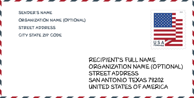
Envelope Example

This is an example of a US zip envelope. You can use a 5-digit zipcode or a detailed 9-digit zipcode to copy the mail in the following address format.
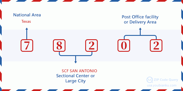
78202 Basic Meaning
What does each digit of ZIP Code 78202 stands for? The first digit designates a national area, which ranges from zero for the Northeast to nine for the far West. The 2-3 digits are the code of a sectional center facility in that region. The last two digits designate small post offices or postal zones.
Online Map

This is online map of the address San Antonio, Texas, United States. You may use button to move and zoom in / out. The map information is for reference only.
Library

This is the ZIP Code 78202 - Library page list. Its detail Library Name, Address, City, State, ZIP Code, Phone is as below.
- Name: BIBLIOTECH EAST
- Address: 1203 N WALTERS ST
- City: SAN ANTONIO
- State: TX - Texas
- ZIP Code: 78202
- Phone: (210) 631-0230
School

This is the ZIP Code 78202 - School page list. Its detail School Name, Address, City, State, ZIP Code is as below.
| School Name | Address | City | State | Grades | ZIP Code |
|---|---|---|---|---|---|
| IDEA CARVER COLLEGE PREPARATORY | 217 ROBINSON PL | SAN ANTONIO | TX | UG | 78202 |
| IDEA CARVER ACADEMY | 217 ROBINSON PL | SAN ANTONIO | TX | UG | 78202 |
| ESSENCE PREPARATORY CHARTER SCHOOL | 1447 E CROCKETT ST | SAN ANTONIO | TX | UG | 78202 |
| HEALY MURPHY PK | 618 LIVE OAK | SAN ANTONIO | TX | UG | 78202 |
| TYNAN EARLY CHILDHOOD CAMPUS | 925 GULF ST | SAN ANTONIO | TX | UG | 78202 |
| YOUNG MEN'S LEADERSHIP ACADEMY | 415 GABRIEL ST | SAN ANTONIO | TX | UG | 78202 |
Population for ZIP Code 78202

What is the total population in ZIP Code 78202? Below is detail information.
- Population for ZIP Code 78202: 13,374
- 2010 Population: 11,691
The 2020 demographic statistics are in progress. The current population in ZIP code 78202 is 13,374, and the population in 2010 is 11,691.
Gender

In all the statistical population, the male population is 5,888, the female population is 5,803.
- Male Population: 5,888
- Female Population: 5,803
Race

In all the statistical population, the male population is 5,888, the female population is 5,803.
- White Population: 5,944
- Black Population: 3,570
- Hispanic Population: 7,675
- Asian Population: 62
- Hawaiian Population: 14
- Indian Population: 233
- Other Population: 2,313
Age

In all the statistical population, the White population is 5,944, the Black population is 3,570, the Hispanic population is 7,675, the Asian population is 62, the Hawaiian population is 14, the Indian Ppopulation is 233 and Other population is 2,313.
- Age's Median: 31.3
- Median of male age: 30.4
- Median of female age: 32.4
Households for ZIP Code 78202
ZIP code 78202 has 3,779 households, with an average number of 2.99 persons per household. The average income per household in Zip code 78202 is 25,300 USD, and the average house value is 73,000 USD.
- Households Per Zipcode: 3,779
- Persons Per Household: 2.99
- Average House Value: 73,000
- Income Per Household: 25,300
Geographic

The latitude of the Zip code 78202 is 29.428012, the longitude is -98.462994, and the elevation is 707. It has land area of 2.325 square miles, and water area of 0 square miles. The time zone for ZIP code 78202 is Central (GMT -06:00). Daylight saving time should be observed in the area where the zip code is located.
- Latitude: 29.428012
- Longitude: -98.462994
- Elevation: 707
- Land Area: 2.325
- Water Area: 0
- Time Zone: Central (GMT -06:00)
- Region: South
- Division: West South Central
- Day Light Saving: Y
Congressional District

The Congressional District for ZIP code 78202 is Texas's 35th congressional district, the Congressional Land Area is 593.77 square mile.
- Congressional District: 35th
- Congressional Land Area: 593.77
Delivery

In the ZIP code 78202, there are 4,473 residential delivery mailboxes and centralized units, and 287 commercial delivery mailbox and centralized units, 3,610 single family deliveries and 572 multifamily deliveries, and the box count is 5,477. The main post office has city delivery carrier routes for the ZIP code 78202.
- Delivery Residential: 4,473
- Delivery Business: 287
- Delivery Total: 5,477
- Single Family Delivery Units: 3,610
- Multi Family Delivery Units: 572
- City Delivery Indicator: Y
Business

In ZIP code 78202, the number of business is 155, the number of employee is 2,089, the business first quarter payroll is 17,807,000 USD, the business annual payroll is 72,151,000 USD.
- Number Of Businesses: 155
- Number Of Employees: 2,089
- Business First Quarter Payroll: 17,807,000
- Business Annual Payroll: 72,151,000
Social Security Benefits

There are 1,905 beneficiaries with benefits in current-payment status for ZIP code 78202, of which 1,075 are retired workers, 470 are disabled workers, 120 are widow(er)s and parents, 60 are spouses and 180 are children. The number of beneficiaries aged 65 or older is 1,140. The total monthly benefits are 1,833,000 USD, of which 1,121,000 USD for retired workers, 118,000 USD for widow(er)s and parents.
- Total Number: 1,905
- Retired workers Number: 1,075
- Disabled workers Number: 470
- Widow(er)s and parents Number: 120
- Spouses Number: 60
- Children Number: 180
- All beneficiaries per month: 1,833,000
- Retired workers per month: 1,121,000
- Widow(er)s and parents per month: 118,000
- Number of beneficiaries aged 65 or older: 1,140


Add new comment