ZIP Code: 78526, Brownsville, TX
ZIP Code 78526 is located in Brownsville, Texas. Its detail State, County, City, Longitude, Latitude, Envelope Example, Population is as below.

ZIP Code 78526 Information

-
-
Country:
U.S. - United States
State:
County FIPS:
48061
County:
City:
Area Code:
City Type ?In many cases, a ZIP Code can have multiple "names", meaning cities, towns, or subdivisions, in its boundaries. However, it will ALWAYS have exactly 1 "default" name. D - Default - This is the "preferred" name - by the USPS - for a city. Each ZIP Code has one - and only one - "default" name. In most cases, this is what people who live in that area call the city as well. A - Acceptable - This name can be used for mailing purposes. Often times alternative names are large neighborhoods or sections of the city/town. In some cases a ZIP Code may have several "acceptable" names which is used to group towns under one ZIP Code. N - Not Acceptable - A "not acceptable" name is, in many cases, a nickname that residents give that location. According to the USPS, you should NOT send mail to that ZIP Code using the "not acceptable" name when mailing.:
D (Default)
ZIP Code:
78526
❓What does D (Default) mean? This is the "preferred" name - by the USPS - for a city. Each ZIP Code has one - and only one - "default" name. In most cases, this is what people who live in that area call the city as well.
ZIP Code 78526 Plus 4
ZIP Code 5 plus 4 is the extension of 5-digit zip code, It can be used to locate a more detailed location. The last four digits designate segment or one side of a street or an apartment. You can find the ZIP+4 code and corresponding address of the zip code 78526 below.
| ZIP Code 5 Plus 4 | Address |
|---|---|
| 78526-0001 | 2701 PAREDES LINE RD #00000181 , BROWNSVILLE, TX |
| 78526-1100 | 2701 PAREDES LINE RD, BROWNSVILLE, TX |
| 78526-1101 | 2701 PAREDES LINE RD, BROWNSVILLE, TX |
| 78526-1102 | 2701 PAREDES LINE RD #00000011 , BROWNSVILLE, TX |
| 78526-1103 | 2701 PAREDES LINE RD #00000182 , BROWNSVILLE, TX |
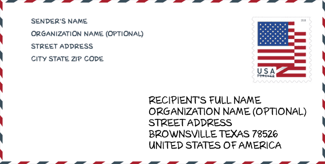
Envelope Example

This is an example of a US zip envelope. You can use a 5-digit zipcode or a detailed 9-digit zipcode to copy the mail in the following address format.
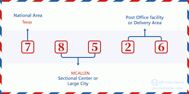
78526 Basic Meaning
What does each digit of ZIP Code 78526 stands for? The first digit designates a national area, which ranges from zero for the Northeast to nine for the far West. The 2-3 digits are the code of a sectional center facility in that region. The last two digits designate small post offices or postal zones.
Online Map

This is online map of the address Brownsville, Texas, United States. You may use button to move and zoom in / out. The map information is for reference only.
Hospital

This is the ZIP Code 78526 - Hospital page list. Its detail Hospital Name, Street, City, State, ZIP Code, Phone is as below.
- Name: VALLEY REGIONAL MEDICAL CENTER
- Address: BROWNSVILLE
- City: 100 A ALTON GLOOR
- State: TX
- ZIP Code: 78526
- Phone: (956) 350-7000
School

This is the ZIP Code 78526 - School page list. Its detail School Name, Address, City, State, ZIP Code is as below.
| School Name | Address | City | State | Grades | ZIP Code |
|---|---|---|---|---|---|
| JUBILEE LIVING WAY | 4955 PABLO KISEL | BROWNSVILLE | TX | UG | 78526 |
| JUBILEE BROWNSVILLE | 4955 PABLO KISEL | BROWNSVILLE | TX | UG | 78526 |
| IDEA BROWNSVILLE COLLEGE PREPARATORY | 4395 PAREDES LINE RD | BROWNSVILLE | TX | UG | 78526 |
| IDEA BROWNSVILLE ACADEMY | 4395 PAREDES LINE RD | BROWNSVILLE | TX | UG | 78526 |
| HARMONY SCHOOL OF INNOVATION - BROWNSVILLE | 3451 DANA AVE | BROWNSVILLE | TX | UG | 78526 |
| PROMESA COLLEGE PREP BROWNSVILLE | 1944 E ALTON GLOOR BLVD | BROWNSVILLE | TX | UG | 78526 |
| BROWNSVILLE ACADEMIC CENTER | 3308 ROBINDALE RD | BROWNSVILLE | TX | UG | 78526 |
| PENA EL | 4975 SALIDA DE LA LUNA | BROWNSVILLE | TX | UG | 78526 |
| OLMITO EL | 2500 ARROYO BLVD | BROWNSVILLE | TX | UG | 78526 |
| DORA ROMERO EL | 9705 CAJUN BLVD | BROWNSVILLE | TX | UG | 78526 |
| RANCHO VERDE EL | 101 RANCHO ALEGRE | BROWNSVILLE | TX | UG | 78526 |
Population for ZIP Code 78526

What is the total population in ZIP Code 78526? Below is detail information.
- Population for ZIP Code 78526: 62,261
- 2010 Population: 42,460
The 2020 demographic statistics are in progress. The current population in ZIP code 78526 is 62,261, and the population in 2010 is 42,460.
Gender

In all the statistical population, the male population is 20,261, the female population is 22,199.
- Male Population: 20,261
- Female Population: 22,199
Race

In all the statistical population, the male population is 20,261, the female population is 22,199.
- White Population: 38,346
- Black Population: 258
- Hispanic Population: 38,851
- Asian Population: 665
- Hawaiian Population: 16
- Indian Population: 207
- Other Population: 3,640
Age

In all the statistical population, the White population is 38,346, the Black population is 258, the Hispanic population is 38,851, the Asian population is 665, the Hawaiian population is 16, the Indian Ppopulation is 207 and Other population is 3,640.
- Age's Median: 29.2
- Median of male age: 27.0
- Median of female age: 31.1
Households for ZIP Code 78526
ZIP code 78526 has 11,477 households, with an average number of 3.68 persons per household. The average income per household in Zip code 78526 is 54,587 USD, and the average house value is 109,200 USD.
- Households Per Zipcode: 11,477
- Persons Per Household: 3.68
- Average House Value: 109,200
- Income Per Household: 54,587
Geographic

The latitude of the Zip code 78526 is 25.992679, the longitude is -97.449762, and the elevation is 11. It has land area of 44.12 square miles, and water area of 1.636 square miles. The time zone for ZIP code 78526 is Central (GMT -06:00). Daylight saving time should be observed in the area where the zip code is located.
- Latitude: 25.992679
- Longitude: -97.449762
- Elevation: 11
- Land Area: 44.12
- Water Area: 1.636
- Time Zone: Central (GMT -06:00)
- Region: South
- Division: West South Central
- Day Light Saving: Y
Congressional District

The Congressional District for ZIP code 78526 is Texas's 34th congressional district, the Congressional Land Area is 8190.32 square mile.
- Congressional District: 34th
- Congressional Land Area: 8190.32
Delivery

In the ZIP code 78526, there are 16,919 residential delivery mailboxes and centralized units, and 973 commercial delivery mailbox and centralized units, 9,302 single family deliveries and 1,541 multifamily deliveries, and the box count is 17,858. The main post office has city delivery carrier routes for the ZIP code 78526.
- Delivery Residential: 16,919
- Delivery Business: 973
- Delivery Total: 17,858
- Single Family Delivery Units: 9,302
- Multi Family Delivery Units: 1,541
- City Delivery Indicator: Y
Business

In ZIP code 78526, the number of business is 590, the number of employee is 10,251, the business first quarter payroll is 68,169,000 USD, the business annual payroll is 291,416,000 USD.
- Number Of Businesses: 590
- Number Of Employees: 10,251
- Business First Quarter Payroll: 68,169,000
- Business Annual Payroll: 291,416,000
Social Security Benefits

There are 6,110 beneficiaries with benefits in current-payment status for ZIP code 78526, of which 3,815 are retired workers, 735 are disabled workers, 540 are widow(er)s and parents, 470 are spouses and 550 are children. The number of beneficiaries aged 65 or older is 4,395. The total monthly benefits are 5,717,000 USD, of which 3,891,000 USD for retired workers, 509,000 USD for widow(er)s and parents.
- Total Number: 6,110
- Retired workers Number: 3,815
- Disabled workers Number: 735
- Widow(er)s and parents Number: 540
- Spouses Number: 470
- Children Number: 550
- All beneficiaries per month: 5,717,000
- Retired workers per month: 3,891,000
- Widow(er)s and parents per month: 509,000
- Number of beneficiaries aged 65 or older: 4,395


Add new comment