United States ZIP Code: 78582
This is the Texas ZIP Code 78582 page list. Its detail State, County, City, Longitude, Latitude, Envelope Example, Population is as below.

ZIP Code 78582 Information

-
-
Country:
U.S. - United States
State:
State FIPS:
48
Area Code:
ZIP Code:
78582
ZIP Type:
S (Standard)
❓What does S (Standard) mean? A "standard" ZIP Code is what most people think of when they talk about ZIP Codes - essentially a town, city, or a division of a city that has mail service.
ZIP Code 78582 - City

This is the city information corresponding to 78582:
| State | County | City | City Type ?In many cases, a ZIP Code can have multiple "names", meaning cities, towns, or subdivisions, in its boundaries. However, it will ALWAYS have exactly 1 "default" name. D - Default - This is the "preferred" name - by the USPS - for a city. Each ZIP Code has one - and only one - "default" name. In most cases, this is what people who live in that area call the city as well. A - Acceptable - This name can be used for mailing purposes. Often times alternative names are large neighborhoods or sections of the city/town. In some cases a ZIP Code may have several "acceptable" names which is used to group towns under one ZIP Code. N - Not Acceptable - A "not acceptable" name is, in many cases, a nickname that residents give that location. According to the USPS, you should NOT send mail to that ZIP Code using the "not acceptable" name when mailing. | ZIP Code |
|---|---|---|---|---|
| TX | Starr | El Sauz | N (Not Acceptable) | 78582 |
| TX | Starr | Escobares | N (Not Acceptable) | 78582 |
| TX | Starr | Fort Ringgold | N (Not Acceptable) | 78582 |
| TX | Starr | Garceno | N (Not Acceptable) | 78582 |
| TX | Starr | La Casita | N (Not Acceptable) | 78582 |
| TX | Starr | Rincon | N (Not Acceptable) | 78582 |
| TX | Starr | Rio Grande | N (Not Acceptable) | 78582 |
| TX | Starr | Rio Grande City | D (Default) | 78582 |
| TX | Starr | Rio Grande Cy | A (Acceptable) | 78582 |
| TX | Starr | Santa Catarina | N (Not Acceptable) | 78582 |
| TX | Starr | Santa Cruz | N (Not Acceptable) | 78582 |
| TX | Starr | Villareales | N (Not Acceptable) | 78582 |
❓What does D (Default) mean? This is the "preferred" name - by the USPS - for a city. Each ZIP Code has one - and only one - "default" name. In most cases, this is what people who live in that area call the city as well.
❓What does A (Acceptable) mean? This name can be used for mailing purposes. Often times alternative names are large neighborhoods or sections of the city/town. In some cases a ZIP Code may have several "acceptable" names which is used to group towns under one ZIP Code.
❓What does N (Not Acceptable) mean? A "not acceptable" name is, in many cases, a nickname that residents give that location. According to the USPS, you should NOT send mail to that ZIP Code using the "not acceptable" name when mailing.
ZIP Code 78582 Plus 4
ZIP Code 5 plus 4 is the extension of 5-digit zip code, It can be used to locate a more detailed location. The last four digits designate segment or one side of a street or an apartment. You can find the ZIP+4 code and corresponding address of the zip code 78582 below.
| ZIP Code 5 Plus 4 | Address |
|---|---|
| 78582-0001 | PO BOX 1, RIO GRANDE CITY, TX |
| 78582-0080 | PO BOX 80, RIO GRANDE CITY, TX |
| 78582-0120 | PO BOX 120, RIO GRANDE CITY, TX |
| 78582-0160 | PO BOX 160, RIO GRANDE CITY, TX |
| 78582-0280 | PO BOX 280, RIO GRANDE CITY, TX |
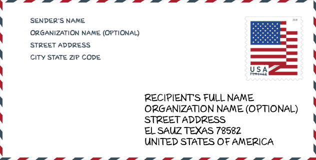
Envelope Example

This is an example of a US zip envelope. You can use a 5-digit zipcode or a detailed 9-digit zipcode to copy the mail in the following address format.
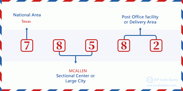
78582 Basic Meaning
What does each digit of ZIP Code 78582 stands for? The first digit designates a national area, which ranges from zero for the Northeast to nine for the far West. The 2-3 digits are the code of a sectional center facility in that region. The last two digits designate small post offices or postal zones.
Online Map

This is online map of the address Villareales, Texas, United States. You may use button to move and zoom in / out. The map information is for reference only.
Hospital

This is the ZIP Code 78582 - Hospital page list. Its detail Hospital Name, Street, City, State, ZIP Code, Phone is as below.
- Name: STARR COUNTY MEMORIAL HOSPITAL
- Address: RIO GRANDE CITY
- City: 128 N FM RD 3167
- State: TX
- ZIP Code: 78582
- Phone: (956) 487-5561
Library

This is the ZIP Code 78582 - Library page list. Its detail Library Name, Address, City, State, ZIP Code, Phone is as below.
- Name: RIO GRANDE CITY PUBLIC LIBRARY
- Address: 591 E CANALES BROS ST
- City: RIO GRANDE CITY
- State: TX - Texas
- ZIP Code: 78582
- Phone: (956) 487-4389
School

This is the ZIP Code 78582 - School page list. Its detail School Name, Address, City, State, ZIP Code is as below.
| School Name | Address | City | State | Grades | ZIP Code |
|---|---|---|---|---|---|
| IDEA RIO GRANDE CITY COLLEGE PREPARATORY | 2803 W MONARCH LN | RIO GRANDE CITY | TX | UG | 78582 |
| IDEA RIO GRANDE CITY ACADEMY | 2803 W MONARCH LN | RIO GRANDE CITY | TX | UG | 78582 |
| RINGGOLD EL | 1 S FORT RINGGOLD | RIO GRANDE CITY | TX | UG | 78582 |
| JOHN & OLIVE HINOJOSA EL | 2448 EMBASSY ST | RIO GRANDE CITY | TX | UG | 78582 |
| ALTO BONITO EL | 753 FM 2360 | RIO GRANDE CITY | TX | UG | 78582 |
| GENERAL RICARDO SANCHEZ EL | 2801 W EISENHOWER ST | RIO GRANDE CITY | TX | UG | 78582 |
| DR MARIO E RAMIREZ EL | 8001 TROPHY RD | RIO GRANDE CITY | TX | UG | 78582 |
| VETERANS MIDDLE | 2700 W EISENHOWER ST | RIO GRANDE CITY | TX | UG | 78582 |
| PREPARATORY FOR EARLY COLLEGE H S | 144 FM 3167 | RIO GRANDE CITY | TX | UG | 78582 |
| RAMIRO BARRERA MIDDLE | 258 N FM 649 | RIO GRANDE CITY | TX | UG | 78582 |
| DELIA GONZALEZ GARCIA EL | 4186 W US HWY 83 | RIO GRANDE CITY | TX | UG | 78582 |
Population for ZIP Code 78582

What is the total population in ZIP Code 78582? Below is detail information.
- Population for ZIP Code 78582: 43,450
- 2010 Population: 40,455
The 2020 demographic statistics are in progress. The current population in ZIP code 78582 is 43,450, and the population in 2010 is 40,455.
Gender

In all the statistical population, the male population is 19,925, the female population is 20,530.
- Male Population: 19,925
- Female Population: 20,530
Race

In all the statistical population, the male population is 19,925, the female population is 20,530.
- White Population: 38,687
- Black Population: 69
- Hispanic Population: 38,893
- Asian Population: 142
- Hawaiian Population: 9
- Indian Population: 100
- Other Population: 1,705
Age

In all the statistical population, the White population is 38,687, the Black population is 69, the Hispanic population is 38,893, the Asian population is 142, the Hawaiian population is 9, the Indian Ppopulation is 100 and Other population is 1,705.
- Age's Median: 28.5
- Median of male age: 27.2
- Median of female age: 29.7
Households for ZIP Code 78582
ZIP code 78582 has 10,965 households, with an average number of 3.62 persons per household. The average income per household in Zip code 78582 is 31,880 USD, and the average house value is 68,700 USD.
- Households Per Zipcode: 10,965
- Persons Per Household: 3.62
- Average House Value: 68,700
- Income Per Household: 31,880
Geographic

The latitude of the Zip code 78582 is 26.510284, the longitude is -98.675196, and the elevation is 442. It has land area of 651.071 square miles, and water area of 1.84 square miles. The time zone for ZIP code 78582 is Central (GMT -06:00). Daylight saving time should be observed in the area where the zip code is located.
- Latitude: 26.510284
- Longitude: -98.675196
- Elevation: 442
- Land Area: 651.071
- Water Area: 1.84
- Time Zone: Central (GMT -06:00)
- Region: South
- Division: West South Central
- Day Light Saving: Y
Congressional District

The Congressional District for ZIP code 78582 is Texas's 28th congressional district, the Congressional Land Area is 9378.53 square mile.
- Congressional District: 28th
- Congressional Land Area: 9378.53
Delivery

In the ZIP code 78582, there are 12,003 residential delivery mailboxes and centralized units, and 821 commercial delivery mailbox and centralized units, 10,122 single family deliveries and 456 multifamily deliveries, and the box count is 14,016. The main post office has city delivery carrier routes for the ZIP code 78582.
- Delivery Residential: 12,003
- Delivery Business: 821
- Delivery Total: 14,016
- Single Family Delivery Units: 10,122
- Multi Family Delivery Units: 456
- City Delivery Indicator: Y
Business

In ZIP code 78582, the number of business is 404, the number of employee is 7,700, the business first quarter payroll is 39,695,000 USD, the business annual payroll is 158,789,000 USD.
- Number Of Businesses: 404
- Number Of Employees: 7,700
- Business First Quarter Payroll: 39,695,000
- Business Annual Payroll: 158,789,000
Social Security Benefits

There are 5,440 beneficiaries with benefits in current-payment status for ZIP code 78582, of which 3,130 are retired workers, 805 are disabled workers, 595 are widow(er)s and parents, 425 are spouses and 485 are children. The number of beneficiaries aged 65 or older is 3,710. The total monthly benefits are 4,270,000 USD, of which 2,600,000 USD for retired workers, 496,000 USD for widow(er)s and parents.
- Total Number: 5,440
- Retired workers Number: 3,130
- Disabled workers Number: 805
- Widow(er)s and parents Number: 595
- Spouses Number: 425
- Children Number: 485
- All beneficiaries per month: 4,270,000
- Retired workers per month: 2,600,000
- Widow(er)s and parents per month: 496,000
- Number of beneficiaries aged 65 or older: 3,710


Add new comment