United States ZIP Code: 78712
This is the Texas ZIP Code 78712 page list. Its detail State, County, City, Longitude, Latitude, Envelope Example, Population is as below.

ZIP Code 78712 Information

-
-
Country:
U.S. - United States
State:
State FIPS:
48
ZIP Code:
78712
ZIP Type:
S (Standard)
❓What does S (Standard) mean? A "standard" ZIP Code is what most people think of when they talk about ZIP Codes - essentially a town, city, or a division of a city that has mail service.
ZIP Code 78712 - City

This is the city information corresponding to 78712:
| State | County | City | City Type ?In many cases, a ZIP Code can have multiple "names", meaning cities, towns, or subdivisions, in its boundaries. However, it will ALWAYS have exactly 1 "default" name. D - Default - This is the "preferred" name - by the USPS - for a city. Each ZIP Code has one - and only one - "default" name. In most cases, this is what people who live in that area call the city as well. A - Acceptable - This name can be used for mailing purposes. Often times alternative names are large neighborhoods or sections of the city/town. In some cases a ZIP Code may have several "acceptable" names which is used to group towns under one ZIP Code. N - Not Acceptable - A "not acceptable" name is, in many cases, a nickname that residents give that location. According to the USPS, you should NOT send mail to that ZIP Code using the "not acceptable" name when mailing. | ZIP Code |
|---|---|---|---|---|
| TX | Travis | Austin | D (Default) | 78712 |
| TX | Travis | The University Of Texas | N (Not Acceptable) | 78712 |
| TX | Travis | University Of Texas | N (Not Acceptable) | 78712 |
| TX | Travis | Ut | N (Not Acceptable) | 78712 |
❓What does D (Default) mean? This is the "preferred" name - by the USPS - for a city. Each ZIP Code has one - and only one - "default" name. In most cases, this is what people who live in that area call the city as well.
❓What does N (Not Acceptable) mean? A "not acceptable" name is, in many cases, a nickname that residents give that location. According to the USPS, you should NOT send mail to that ZIP Code using the "not acceptable" name when mailing.
ZIP Code 78712 Plus 4
ZIP Code 5 plus 4 is the extension of 5-digit zip code, It can be used to locate a more detailed location. The last four digits designate segment or one side of a street or an apartment. You can find the ZIP+4 code and corresponding address of the zip code 78712 below.
| ZIP Code 5 Plus 4 | Address |
|---|---|
| 78712-0001 | 4101 BONSONTI, AUSTIN, TX |
| 78712-0100 | 1 UNIVERSITY STA, AUSTIN, TX |
| 78712-0102 | 1 UNIVERSITY STA #D9500 , AUSTIN, TX |
| 78712-0103 | 1 UNIVERSITY STA #A0500 , AUSTIN, TX |
| 78712-0104 | 1 UNIVERSITY STA #A0600 , AUSTIN, TX |
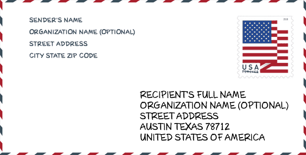
Envelope Example

This is an example of a US zip envelope. You can use a 5-digit zipcode or a detailed 9-digit zipcode to copy the mail in the following address format.
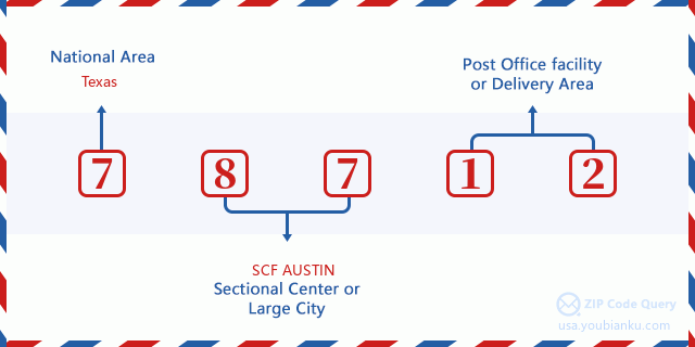
78712 Basic Meaning
What does each digit of ZIP Code 78712 stands for? The first digit designates a national area, which ranges from zero for the Northeast to nine for the far West. The 2-3 digits are the code of a sectional center facility in that region. The last two digits designate small post offices or postal zones.
Online Map

This is online map of the address Ut, Texas, United States. You may use button to move and zoom in / out. The map information is for reference only.
Museum

This is the ZIP Code 78712 - Museum page list. Its detail Museum Name, Street, City, State, ZIP Code, Phone is as below.
| Name | Street | City | State | ZIP Code | Phone |
| LANDMARKS PUBLIC ART PROGRAM | 1 UNIVERSITY STA | AUSTIN | TX | 78712 | (512) 495-4315 |
| DOLPH BRISCOE CENTER FOR AMERICAN HISTORY | 2300 RED RIVER ST | AUSTIN | TX | 78712 | (512) 495-4518 |
| H.J. LUTCHER STARK CENTER FOR PHYSICAL CULTURE AND SPORTS | 403 EAST 23RD STREET | AUSTIN | TX | 78712 | (512) 471-4890 |
| HARRY RANSOM CENTER | 300 WEST 21ST STREET | AUSTIN | TX | 78712 | |
| W. L. MOODY JR. VISITORS INFORMATION CENTER | 2400 INNER CAMPUS DRIVE | AUSTIN | TX | 78712 | |
| ARCHER M. HUNTINGTON ART GALLERY | 200 EAST MARTIN LUTHER KING JUNIOR BOULEVARD | AUSTIN | TX | 78712 | (512) 471-7324 |
Gender

In all the statistical population, the male population is 432, the female population is 428.
- Male Population: 432
- Female Population: 428
Race

In all the statistical population, the male population is 432, the female population is 428.
- White Population: 632
- Black Population: 61
- Hispanic Population: 131
- Asian Population: 159
- Hawaiian Population: 0
- Indian Population: 3
- Other Population: 33
Age

In all the statistical population, the White population is 632, the Black population is 61, the Hispanic population is 131, the Asian population is 159, the Hawaiian population is 0, the Indian Ppopulation is 3 and Other population is 33.
- Age's Median: 19.5
- Median of male age: 19.5
- Median of female age: 19.4
Households for ZIP Code 78712
ZIP code 78712 has 0 households, with an average number of 0.00 persons per household. The average income per household in Zip code 78712 is 0 USD, and the average house value is 0 USD.
- Households Per Zipcode: 0
- Persons Per Household: 0.00
- Average House Value: 0
- Income Per Household: 0
Housing Unit

In ZIP code 78712, the growth rank of housing unit is 28, the number of housing unit was 1,024,272 in 2010 and increased to 1,063,130 in 2011, the growth increase number is 38,858, the growth increase percentage is 3.8%.
- Growth Rank: 28
- Housing Units Estimate in 2010: 1,024,272
- Housing Units Estimate in 2011: 1,063,130
- Growth Increase Number: 38,858
- Growth Increase Percentage: 3.8%
Geographic

The latitude of the Zip code 78712 is 30.285400, the longitude is -97.733175, and the elevation is 529. It has land area of 0.318 square miles, and water area of 0 square miles. The time zone for ZIP code 78712 is Central (GMT -06:00). Daylight saving time should be observed in the area where the zip code is located.
- Latitude: 30.285400
- Longitude: -97.733175
- Elevation: 529
- Land Area: 0.318
- Water Area: 0
- Time Zone: Central (GMT -06:00)
- Region: South
- Division: West South Central
- Day Light Saving: Y
Congressional District

The Congressional District for ZIP code 78712 is Texas's 25th congressional district, the Congressional Land Area is 7620.7 square mile.
- Congressional District: 25th
- Congressional Land Area: 7620.7
Delivery

In the ZIP code 78712, there are 0 residential delivery mailboxes and centralized units, and 22 commercial delivery mailbox and centralized units, 0 single family deliveries and 0 multifamily deliveries, and the box count is 21. The main post office has city delivery carrier routes for the ZIP code 78712.
- Delivery Residential: 0
- Delivery Business: 22
- Delivery Total: 21
- Single Family Delivery Units: 0
- Multi Family Delivery Units: 0
- City Delivery Indicator: Y
Business

In ZIP code 78712, the number of business is 35, the number of employee is 496, the business first quarter payroll is 4,107,000 USD, the business annual payroll is 17,995,000 USD.
- Number Of Businesses: 35
- Number Of Employees: 496
- Business First Quarter Payroll: 4,107,000
- Business Annual Payroll: 17,995,000


Add new comment