ZIP Code: 79901, El Paso, TX
ZIP Code 79901 is located in El Paso, Texas. Its detail State, County, City, Longitude, Latitude, Envelope Example, Population is as below.
ZIP Code 79901 Information

-
-
Country:
U.S. - United States
State:
County FIPS:
48141
County:
City:
Area Code:
City Type ?In many cases, a ZIP Code can have multiple "names", meaning cities, towns, or subdivisions, in its boundaries. However, it will ALWAYS have exactly 1 "default" name. D - Default - This is the "preferred" name - by the USPS - for a city. Each ZIP Code has one - and only one - "default" name. In most cases, this is what people who live in that area call the city as well. A - Acceptable - This name can be used for mailing purposes. Often times alternative names are large neighborhoods or sections of the city/town. In some cases a ZIP Code may have several "acceptable" names which is used to group towns under one ZIP Code. N - Not Acceptable - A "not acceptable" name is, in many cases, a nickname that residents give that location. According to the USPS, you should NOT send mail to that ZIP Code using the "not acceptable" name when mailing.:
D (Default)
ZIP Code:
79901
❓What does D (Default) mean? This is the "preferred" name - by the USPS - for a city. Each ZIP Code has one - and only one - "default" name. In most cases, this is what people who live in that area call the city as well.
ZIP Code 79901 Plus 4
ZIP Code 5 plus 4 is the extension of 5-digit zip code, It can be used to locate a more detailed location. The last four digits designate segment or one side of a street or an apartment. You can find the ZIP+4 code and corresponding address of the zip code 79901 below.
| ZIP Code 5 Plus 4 | Address |
|---|---|
| 79901-1000 | 515 W MISSOURI AVE #00000001 , EL PASO, TX |
| 79901-1001 | 424 S DURANGO ST #A , EL PASO, TX |
| 79901-1002 | 504 W SAN ANTONIO AVE, EL PASO, TX |
| 79901-1003 | 301 CHIHUAHUA ST, EL PASO, TX |
| 79901-1004 | 300 CHIHUAHUA ST, EL PASO, TX |
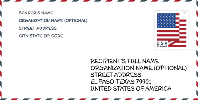
Envelope Example

This is an example of a US zip envelope. You can use a 5-digit zipcode or a detailed 9-digit zipcode to copy the mail in the following address format.
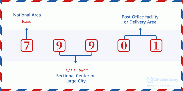
79901 Basic Meaning
What does each digit of ZIP Code 79901 stands for? The first digit designates a national area, which ranges from zero for the Northeast to nine for the far West. The 2-3 digits are the code of a sectional center facility in that region. The last two digits designate small post offices or postal zones.
Online Map

This is online map of the address El Paso, Texas, United States. You may use button to move and zoom in / out. The map information is for reference only.
Museum

This is the ZIP Code 79901 - Museum page list. Its detail Museum Name, Street, City, State, ZIP Code, Phone is as below.
| Name | Street | City | State | ZIP Code | Phone |
| MAGOFFIN HOME STATE HISTORIC | 1120 MAGOFFIN AVE | EL PASO | TX | 79901 | (915) 533-5147 |
| EL PASO MUSEUM OF HISTORY | 510 N SANTA FE ST | EL PASO | TX | 79901 | (915) 351-3588 |
| CHILDREN'S MUSEUM OF EL PASO | 400 WEST SAN ANTONIO STREET, SUITE A | EL PASO | TX | 79901 | (915) 541-4898 |
Library

This is the ZIP Code 79901 - Library page list. Its detail Library Name, Address, City, State, ZIP Code, Phone is as below.
| Name | Address | City | State | ZIP Code | Phone |
|---|---|---|---|---|---|
| ARMIJO BRANCH LIBRARY | 620 E 7TH AVE | EL PASO | TX | 79901 | (915) 212-0369 |
| BOOKMOBILE - EL PASO PUBLIC LIBRARY | 501 N OREGON ST | EL PASO | TX | 79901 | (915) 543-5412 |
| EL PASO PUBLIC LIBRARY | 501 N OREGON ST | EL PASO | TX | 79901 | (915) 212-7323 |
| KIDSMOBILE | 501 N OREGON ST | EL PASO | TX | 79901 | (915) 212-3203 |
School

This is the ZIP Code 79901 - School page list. Its detail School Name, Address, City, State, ZIP Code is as below.
- School Name: LA FE PREPARATORY SCHOOL
- Address: 616 E FATHER RAHM AVE
- City: EL PASO
- State: TX
- Grades: UG
- ZIP Code: 79901
Population for ZIP Code 79901

What is the total population in ZIP Code 79901? Below is detail information.
- Population for ZIP Code 79901: 11,683
- 2010 Population: 11,328
The 2020 demographic statistics are in progress. The current population in ZIP code 79901 is 11,683, and the population in 2010 is 11,328.
Gender

In all the statistical population, the male population is 5,389, the female population is 5,939.
- Male Population: 5,389
- Female Population: 5,939
Race

In all the statistical population, the male population is 5,389, the female population is 5,939.
- White Population: 9,286
- Black Population: 152
- Hispanic Population: 10,779
- Asian Population: 31
- Hawaiian Population: 3
- Indian Population: 110
- Other Population: 2,014
Age

In all the statistical population, the White population is 9,286, the Black population is 152, the Hispanic population is 10,779, the Asian population is 31, the Hawaiian population is 3, the Indian Ppopulation is 110 and Other population is 2,014.
- Age's Median: 36.0
- Median of male age: 34.5
- Median of female age: 37.3
Households for ZIP Code 79901
ZIP code 79901 has 4,206 households, with an average number of 2.57 persons per household. The average income per household in Zip code 79901 is 13,893 USD, and the average house value is 56,000 USD.
- Households Per Zipcode: 4,206
- Persons Per Household: 2.57
- Average House Value: 56,000
- Income Per Household: 13,893
Housing Unit

In ZIP code 79901, the growth rank of housing unit is 89, the number of housing unit was 800,647 in 2010 and increased to 820,790 in 2011, the growth increase number is 20,143, the growth increase percentage is 2.5%.
- Growth Rank: 89
- Housing Units Estimate in 2010: 800,647
- Housing Units Estimate in 2011: 820,790
- Growth Increase Number: 20,143
- Growth Increase Percentage: 2.5%
Geographic

The latitude of the Zip code 79901 is 31.762995, the longitude is -106.485636, and the elevation is 3726. It has land area of 2.199 square miles, and water area of 0.008 square miles. The time zone for ZIP code 79901 is Mountain (GMT -07:00). Daylight saving time should be observed in the area where the zip code is located.
- Latitude: 31.762995
- Longitude: -106.485636
- Elevation: 3726
- Land Area: 2.199
- Water Area: 0.008
- Time Zone: Mountain (GMT -07:00)
- Region: South
- Division: West South Central
- Day Light Saving: Y
Congressional District

The Congressional District for ZIP code 79901 is Texas's 16th congressional district, the Congressional Land Area is 710.35 square mile.
- Congressional District: 16th
- Congressional Land Area: 710.35
Delivery

In the ZIP code 79901, there are 4,546 residential delivery mailboxes and centralized units, and 1,764 commercial delivery mailbox and centralized units, 1,214 single family deliveries and 468 multifamily deliveries, and the box count is 6,190. The main post office has city delivery carrier routes for the ZIP code 79901.
- Delivery Residential: 4,546
- Delivery Business: 1,764
- Delivery Total: 6,190
- Single Family Delivery Units: 1,214
- Multi Family Delivery Units: 468
- City Delivery Indicator: Y
Business

In ZIP code 79901, the number of business is 928, the number of employee is 11,616, the business first quarter payroll is 131,587,000 USD, the business annual payroll is 493,131,000 USD.
- Number Of Businesses: 928
- Number Of Employees: 11,616
- Business First Quarter Payroll: 131,587,000
- Business Annual Payroll: 493,131,000
Social Security Benefits

There are 2,925 beneficiaries with benefits in current-payment status for ZIP code 79901, of which 1,880 are retired workers, 420 are disabled workers, 255 are widow(er)s and parents, 255 are spouses and 115 are children. The number of beneficiaries aged 65 or older is 2,230. The total monthly benefits are 2,036,000 USD, of which 1,326,000 USD for retired workers, 193,000 USD for widow(er)s and parents.
- Total Number: 2,925
- Retired workers Number: 1,880
- Disabled workers Number: 420
- Widow(er)s and parents Number: 255
- Spouses Number: 255
- Children Number: 115
- All beneficiaries per month: 2,036,000
- Retired workers per month: 1,326,000
- Widow(er)s and parents per month: 193,000
- Number of beneficiaries aged 65 or older: 2,230


Add new comment