ZIP Code: 79905, El Paso, TX
ZIP Code 79905 is located in El Paso, Texas. Its detail State, County, City, Longitude, Latitude, Envelope Example, Population is as below.
ZIP Code 79905 Information

-
-
Country:
U.S. - United States
State:
County FIPS:
48141
County:
City:
Area Code:
City Type ?In many cases, a ZIP Code can have multiple "names", meaning cities, towns, or subdivisions, in its boundaries. However, it will ALWAYS have exactly 1 "default" name. D - Default - This is the "preferred" name - by the USPS - for a city. Each ZIP Code has one - and only one - "default" name. In most cases, this is what people who live in that area call the city as well. A - Acceptable - This name can be used for mailing purposes. Often times alternative names are large neighborhoods or sections of the city/town. In some cases a ZIP Code may have several "acceptable" names which is used to group towns under one ZIP Code. N - Not Acceptable - A "not acceptable" name is, in many cases, a nickname that residents give that location. According to the USPS, you should NOT send mail to that ZIP Code using the "not acceptable" name when mailing.:
D (Default)
ZIP Code:
79905
❓What does D (Default) mean? This is the "preferred" name - by the USPS - for a city. Each ZIP Code has one - and only one - "default" name. In most cases, this is what people who live in that area call the city as well.
ZIP Code 79905 Plus 4
ZIP Code 5 plus 4 is the extension of 5-digit zip code, It can be used to locate a more detailed location. The last four digits designate segment or one side of a street or an apartment. You can find the ZIP+4 code and corresponding address of the zip code 79905 below.
| ZIP Code 5 Plus 4 | Address |
|---|---|
| 79905-1000 | 3119 FRUTAS AVE #00000001 , EL PASO, TX |
| 79905-1001 | 2901 DURAZNO AVE, EL PASO, TX |
| 79905-1002 | 2900 DURAZNO AVE, EL PASO, TX |
| 79905-1003 | 3001 DURAZNO AVE, EL PASO, TX |
| 79905-1004 | 3000 DURAZNO AVE, EL PASO, TX |
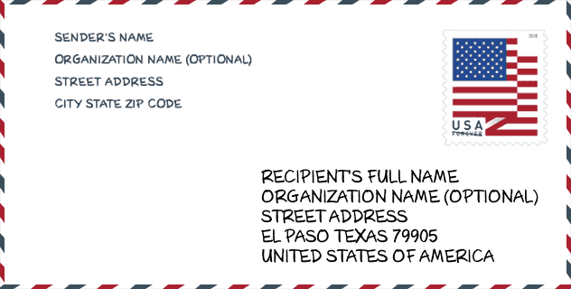
Envelope Example

This is an example of a US zip envelope. You can use a 5-digit zipcode or a detailed 9-digit zipcode to copy the mail in the following address format.
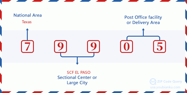
79905 Basic Meaning
What does each digit of ZIP Code 79905 stands for? The first digit designates a national area, which ranges from zero for the Northeast to nine for the far West. The 2-3 digits are the code of a sectional center facility in that region. The last two digits designate small post offices or postal zones.
Online Map

This is online map of the address El Paso, Texas, United States. You may use button to move and zoom in / out. The map information is for reference only.
Hospital

This is the ZIP Code 79905 - Hospital page list. Its detail Hospital Name, Street, City, State, ZIP Code, Phone is as below.
| Name | Address | City | State | ZIP Code | Phone |
|---|---|---|---|---|---|
| EL PASO CHILDREN'S HOSPITAL | 4845 ALAMEDA AVENUE | EL PASO | TX | 79905 | (915) 521-7148 |
| UNIVERSITY MEDICAL CENTER OF EL PASO | 4815 ALAMEDA AVE | EL PASO | TX | 79905 | (915) 521-7602 |
| EL PASO PSYCHIATRIC CENTER | 4615 ALAMEDA AVENUE | EL PASO | TX | 79905 | (915) 532-2202 |
Museum

This is the ZIP Code 79905 - Museum page list. Its detail Museum Name, Street, City, State, ZIP Code, Phone is as below.
| Name | Street | City | State | ZIP Code | Phone |
| EL PASO MODEL RAILROAD AND HISTORICAL ASSOCIATION | 6335 VAUGHN CT | EL PASO | TX | 79905 | |
| CHAMIZAL NATIONAL MEMORIAL | 800 SOUTH SAN MARCIAL STREET | EL PASO | TX | 79905 | (915) 532-7240 |
Library

This is the ZIP Code 79905 - Library page list. Its detail Library Name, Address, City, State, ZIP Code, Phone is as below.
- Name: CLARDY FOX BRANCH LIBRARY
- Address: 5515 ROBERT ALVA AVE
- City: EL PASO
- State: TX - Texas
- ZIP Code: 79905
- Phone: (915) 212-0456
Population for ZIP Code 79905

What is the total population in ZIP Code 79905? Below is detail information.
- Population for ZIP Code 79905: 26,184
- 2010 Population: 26,036
The 2020 demographic statistics are in progress. The current population in ZIP code 79905 is 26,184, and the population in 2010 is 26,036.
Gender

In all the statistical population, the male population is 12,184, the female population is 13,852.
- Male Population: 12,184
- Female Population: 13,852
Race

In all the statistical population, the male population is 12,184, the female population is 13,852.
- White Population: 22,637
- Black Population: 231
- Hispanic Population: 25,319
- Asian Population: 82
- Hawaiian Population: 12
- Indian Population: 211
- Other Population: 3,485
Age

In all the statistical population, the White population is 22,637, the Black population is 231, the Hispanic population is 25,319, the Asian population is 82, the Hawaiian population is 12, the Indian Ppopulation is 211 and Other population is 3,485.
- Age's Median: 34.8
- Median of male age: 31.5
- Median of female age: 37.0
Households for ZIP Code 79905
ZIP code 79905 has 8,363 households, with an average number of 3.07 persons per household. The average income per household in Zip code 79905 is 22,739 USD, and the average house value is 80,500 USD.
- Households Per Zipcode: 8,363
- Persons Per Household: 3.07
- Average House Value: 80,500
- Income Per Household: 22,739
Housing Unit

In ZIP code 79905, the growth rank of housing unit is 89, the number of housing unit was 800,647 in 2010 and increased to 820,790 in 2011, the growth increase number is 20,143, the growth increase percentage is 2.5%.
- Growth Rank: 89
- Housing Units Estimate in 2010: 800,647
- Housing Units Estimate in 2011: 820,790
- Growth Increase Number: 20,143
- Growth Increase Percentage: 2.5%
Geographic

The latitude of the Zip code 79905 is 31.767703, the longitude is -106.430417, and the elevation is 3700. It has land area of 6.506 square miles, and water area of 0.116 square miles. The time zone for ZIP code 79905 is Mountain (GMT -07:00). Daylight saving time should be observed in the area where the zip code is located.
- Latitude: 31.767703
- Longitude: -106.430417
- Elevation: 3700
- Land Area: 6.506
- Water Area: 0.116
- Time Zone: Mountain (GMT -07:00)
- Region: South
- Division: West South Central
- Day Light Saving: Y
Congressional District

The Congressional District for ZIP code 79905 is Texas's 16th congressional district, the Congressional Land Area is 710.35 square mile.
- Congressional District: 16th
- Congressional Land Area: 710.35
Delivery

In the ZIP code 79905, there are 8,529 residential delivery mailboxes and centralized units, and 1,073 commercial delivery mailbox and centralized units, 5,965 single family deliveries and 398 multifamily deliveries, and the box count is 14,223. The main post office has city delivery carrier routes for the ZIP code 79905.
- Delivery Residential: 8,529
- Delivery Business: 1,073
- Delivery Total: 14,223
- Single Family Delivery Units: 5,965
- Multi Family Delivery Units: 398
- City Delivery Indicator: Y
Business

In ZIP code 79905, the number of business is 551, the number of employee is 11,413, the business first quarter payroll is 121,539,000 USD, the business annual payroll is 503,001,000 USD.
- Number Of Businesses: 551
- Number Of Employees: 11,413
- Business First Quarter Payroll: 121,539,000
- Business Annual Payroll: 503,001,000
Social Security Benefits

There are 5,495 beneficiaries with benefits in current-payment status for ZIP code 79905, of which 3,430 are retired workers, 680 are disabled workers, 570 are widow(er)s and parents, 460 are spouses and 355 are children. The number of beneficiaries aged 65 or older is 4,135. The total monthly benefits are 4,735,000 USD, of which 3,123,000 USD for retired workers, 530,000 USD for widow(er)s and parents.
- Total Number: 5,495
- Retired workers Number: 3,430
- Disabled workers Number: 680
- Widow(er)s and parents Number: 570
- Spouses Number: 460
- Children Number: 355
- All beneficiaries per month: 4,735,000
- Retired workers per month: 3,123,000
- Widow(er)s and parents per month: 530,000
- Number of beneficiaries aged 65 or older: 4,135


Add new comment