United States ZIP Code: 81122
This is the Colorado ZIP Code 81122 page list. Its detail State, County, City, Longitude, Latitude, Envelope Example, Population is as below.

ZIP Code 81122 Information

-
-
Country:
U.S. - United States
State:
State FIPS:
08
Area Code:
ZIP Code:
81122
ZIP Type:
S (Standard)
❓What does S (Standard) mean? A "standard" ZIP Code is what most people think of when they talk about ZIP Codes - essentially a town, city, or a division of a city that has mail service.
ZIP Code 81122 - City

This is the city information corresponding to 81122:
| State | County | City | City Type ?In many cases, a ZIP Code can have multiple "names", meaning cities, towns, or subdivisions, in its boundaries. However, it will ALWAYS have exactly 1 "default" name. D - Default - This is the "preferred" name - by the USPS - for a city. Each ZIP Code has one - and only one - "default" name. In most cases, this is what people who live in that area call the city as well. A - Acceptable - This name can be used for mailing purposes. Often times alternative names are large neighborhoods or sections of the city/town. In some cases a ZIP Code may have several "acceptable" names which is used to group towns under one ZIP Code. N - Not Acceptable - A "not acceptable" name is, in many cases, a nickname that residents give that location. According to the USPS, you should NOT send mail to that ZIP Code using the "not acceptable" name when mailing. | ZIP Code |
|---|---|---|---|---|
| CO | La Plata | Bayfield | D (Default) | 81122 |
| CO | La Plata | Chimney Rock | A (Acceptable) | 81122 |
| CO | La Plata | Gem Village | N (Not Acceptable) | 81122 |
| CO | La Plata | Vallecito | N (Not Acceptable) | 81122 |
❓What does D (Default) mean? This is the "preferred" name - by the USPS - for a city. Each ZIP Code has one - and only one - "default" name. In most cases, this is what people who live in that area call the city as well.
❓What does A (Acceptable) mean? This name can be used for mailing purposes. Often times alternative names are large neighborhoods or sections of the city/town. In some cases a ZIP Code may have several "acceptable" names which is used to group towns under one ZIP Code.
❓What does N (Not Acceptable) mean? A "not acceptable" name is, in many cases, a nickname that residents give that location. According to the USPS, you should NOT send mail to that ZIP Code using the "not acceptable" name when mailing.
ZIP Code 81122 Plus 4
ZIP Code 5 plus 4 is the extension of 5-digit zip code, It can be used to locate a more detailed location. The last four digits designate segment or one side of a street or an apartment. You can find the ZIP+4 code and corresponding address of the zip code 81122 below.
| ZIP Code 5 Plus 4 | Address |
|---|---|
| 81122-0001 | PO BOX 1, BAYFIELD, CO |
| 81122-0101 | PO BOX 101, BAYFIELD, CO |
| 81122-0221 | PO BOX 221, BAYFIELD, CO |
| 81122-0311 | PO BOX 311, BAYFIELD, CO |
| 81122-0401 | PO BOX 401, BAYFIELD, CO |
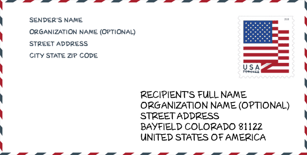
Envelope Example

This is an example of a US zip envelope. You can use a 5-digit zipcode or a detailed 9-digit zipcode to copy the mail in the following address format.
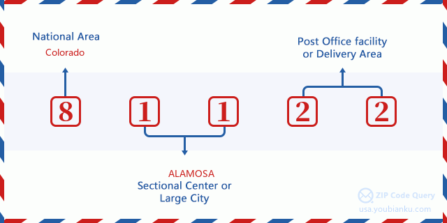
81122 Basic Meaning
What does each digit of ZIP Code 81122 stands for? The first digit designates a national area, which ranges from zero for the Northeast to nine for the far West. The 2-3 digits are the code of a sectional center facility in that region. The last two digits designate small post offices or postal zones.
Online Map

This is online map of the address Vallecito, Colorado, United States. You may use button to move and zoom in / out. The map information is for reference only.
Library

This is the ZIP Code 81122 - Library page list. Its detail Library Name, Address, City, State, ZIP Code, Phone is as below.
- Name: PINE RIVER PUBLIC LIBRARY DISTRICT & BAYFIELD
- Address: 395 BAYFIELD CENTER DRIVE
- City: BAYFIELD
- State: CO - Colorado
- ZIP Code: 81122
- Phone: (970) 884-2222
School

This is the ZIP Code 81122 - School page list. Its detail School Name, Address, City, State, ZIP Code is as below.
| School Name | Address | City | State | Grades | ZIP Code |
|---|---|---|---|---|---|
| Bayfield Intermediate School | 720 E OAK | BAYFIELD | CO | UG | 81122 |
| Bayfield Middle School | 615 E. OAK | BAYFIELD | CO | UG | 81122 |
| Bayfield High School | 800 CO RD 501 | BAYFIELD | CO | UG | 81122 |
Population for ZIP Code 81122

What is the total population in ZIP Code 81122? Below is detail information.
- Population for ZIP Code 81122: 8,685
- 2010 Population: 8,228
The 2020 demographic statistics are in progress. The current population in ZIP code 81122 is 8,685, and the population in 2010 is 8,228.
Gender

In all the statistical population, the male population is 4,155, the female population is 4,073.
- Male Population: 4,155
- Female Population: 4,073
Race

In all the statistical population, the male population is 4,155, the female population is 4,073.
- White Population: 7,709
- Black Population: 52
- Hispanic Population: 725
- Asian Population: 36
- Hawaiian Population: 11
- Indian Population: 489
- Other Population: 223
Age

In all the statistical population, the White population is 7,709, the Black population is 52, the Hispanic population is 725, the Asian population is 36, the Hawaiian population is 11, the Indian Ppopulation is 489 and Other population is 223.
- Age's Median: 40.3
- Median of male age: 39.9
- Median of female age: 40.6
Households for ZIP Code 81122
ZIP code 81122 has 3,292 households, with an average number of 2.50 persons per household. The average income per household in Zip code 81122 is 62,066 USD, and the average house value is 318,800 USD.
- Households Per Zipcode: 3,292
- Persons Per Household: 2.50
- Average House Value: 318,800
- Income Per Household: 62,066
Geographic

The latitude of the Zip code 81122 is 37.377315, the longitude is -107.470719, and the elevation is 10028. It has land area of 507.222 square miles, and water area of 4.325 square miles. The time zone for ZIP code 81122 is Mountain (GMT -07:00). Daylight saving time should be observed in the area where the zip code is located.
- Latitude: 37.377315
- Longitude: -107.470719
- Elevation: 10028
- Land Area: 507.222
- Water Area: 4.325
- Time Zone: Mountain (GMT -07:00)
- Region: West
- Division: Mountain
- Day Light Saving: Y
Congressional District

The Congressional District for ZIP code 81122 is Colorado's 3rd congressional district, the Congressional Land Area is 49731.77 square mile.
- Congressional District: 3rd
- Congressional Land Area: 49731.77
Delivery

In the ZIP code 81122, there are 3,474 residential delivery mailboxes and centralized units, and 110 commercial delivery mailbox and centralized units, 1,242 single family deliveries and 307 multifamily deliveries, and the box count is 4,671. The main post office does not have city delivery carrier routes for the ZIP code 81122.
- Delivery Residential: 3,474
- Delivery Business: 110
- Delivery Total: 4,671
- Single Family Delivery Units: 1,242
- Multi Family Delivery Units: 307
- City Delivery Indicator: N
Business

In ZIP code 81122, the number of business is 213, the number of employee is 888, the business first quarter payroll is 7,145,000 USD, the business annual payroll is 33,083,000 USD.
- Number Of Businesses: 213
- Number Of Employees: 888
- Business First Quarter Payroll: 7,145,000
- Business Annual Payroll: 33,083,000
Social Security Benefits

There are 1,885 beneficiaries with benefits in current-payment status for ZIP code 81122, of which 1,485 are retired workers, 155 are disabled workers, 85 are widow(er)s and parents, 80 are spouses and 80 are children. The number of beneficiaries aged 65 or older is 1,550. The total monthly benefits are 2,653,000 USD, of which 2,189,000 USD for retired workers, 118,000 USD for widow(er)s and parents.
- Total Number: 1,885
- Retired workers Number: 1,485
- Disabled workers Number: 155
- Widow(er)s and parents Number: 85
- Spouses Number: 80
- Children Number: 80
- All beneficiaries per month: 2,653,000
- Retired workers per month: 2,189,000
- Widow(er)s and parents per month: 118,000
- Number of beneficiaries aged 65 or older: 1,550


Add new comment