United States ZIP Code: 84653
This is the Utah ZIP Code 84653 page list. Its detail State, County, City, Longitude, Latitude, Envelope Example, Population is as below.

ZIP Code 84653 Information

ZIP Code 84653 - City

This is the city information corresponding to 84653:
| State | County | City | City Type ?In many cases, a ZIP Code can have multiple "names", meaning cities, towns, or subdivisions, in its boundaries. However, it will ALWAYS have exactly 1 "default" name. D - Default - This is the "preferred" name - by the USPS - for a city. Each ZIP Code has one - and only one - "default" name. In most cases, this is what people who live in that area call the city as well. A - Acceptable - This name can be used for mailing purposes. Often times alternative names are large neighborhoods or sections of the city/town. In some cases a ZIP Code may have several "acceptable" names which is used to group towns under one ZIP Code. N - Not Acceptable - A "not acceptable" name is, in many cases, a nickname that residents give that location. According to the USPS, you should NOT send mail to that ZIP Code using the "not acceptable" name when mailing. | ZIP Code |
|---|---|---|---|---|
| UT | Utah | Salem | D (Default) | 84653 |
| UT | Utah | Woodland Hills | A (Acceptable) | 84653 |
| UT | Utah | Woodland Hls | A (Acceptable) | 84653 |
❓What does D (Default) mean? This is the "preferred" name - by the USPS - for a city. Each ZIP Code has one - and only one - "default" name. In most cases, this is what people who live in that area call the city as well.
❓What does A (Acceptable) mean? This name can be used for mailing purposes. Often times alternative names are large neighborhoods or sections of the city/town. In some cases a ZIP Code may have several "acceptable" names which is used to group towns under one ZIP Code.
ZIP Code 84653 Plus 4
ZIP Code 5 plus 4 is the extension of 5-digit zip code, It can be used to locate a more detailed location. The last four digits designate segment or one side of a street or an apartment. You can find the ZIP+4 code and corresponding address of the zip code 84653 below.
| ZIP Code 5 Plus 4 | Address |
|---|---|
| 84653-0001 | PO BOX 1, SALEM, UT |
| 84653-0120 | PO BOX 120, SALEM, UT |
| 84653-0180 | PO BOX 180, SALEM, UT |
| 84653-0300 | PO BOX 300, SALEM, UT |
| 84653-0420 | PO BOX 420, SALEM, UT |
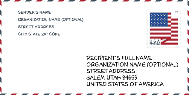
Envelope Example

This is an example of a US zip envelope. You can use a 5-digit zipcode or a detailed 9-digit zipcode to copy the mail in the following address format.
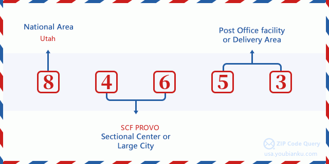
84653 Basic Meaning
What does each digit of ZIP Code 84653 stands for? The first digit designates a national area, which ranges from zero for the Northeast to nine for the far West. The 2-3 digits are the code of a sectional center facility in that region. The last two digits designate small post offices or postal zones.
Online Map

This is online map of the address Woodland Hls, Utah, United States. You may use button to move and zoom in / out. The map information is for reference only.
Library

This is the ZIP Code 84653 - Library page list. Its detail Library Name, Address, City, State, ZIP Code, Phone is as below.
- Name: SALEM CITY LIBRARY
- Address: 59 SOUTH MAIN STREET
- City: SALEM
- State: UT - Utah
- ZIP Code: 84653
- Phone: (801) 423-2622
School

This is the ZIP Code 84653 - School page list. Its detail School Name, Address, City, State, ZIP Code is as below.
| School Name | Address | City | State | Grades | ZIP Code |
|---|---|---|---|---|---|
| American Preparatory Academy - Salem | 1195 S Elk Ridge Drive | SALEM | UT | UG | 84653 |
| Salem School | 140 W 100 S | SALEM | UT | UG | 84653 |
| Mt. Loafer School | 1025 S 250 W | SALEM | UT | UG | 84653 |
| Foothills School | 412 S 810 E | SALEM | UT | UG | 84653 |
| Salem Hills High | 150 N SKYHAWK BLVD | SALEM | UT | UG | 84653 |
| Salem Junior High | 598 NORTH MAIN | SALEM | UT | UG | 84653 |
| Valley View Middle | 1044 E 340 S | SALEM | UT | UG | 84653 |
Population for ZIP Code 84653

What is the total population in ZIP Code 84653? Below is detail information.
- Population for ZIP Code 84653: 10,794
- 2010 Population: 7,947
The 2020 demographic statistics are in progress. The current population in ZIP code 84653 is 10,794, and the population in 2010 is 7,947.
Gender

In all the statistical population, the male population is 4,004, the female population is 3,943.
- Male Population: 4,004
- Female Population: 3,943
Race

In all the statistical population, the male population is 4,004, the female population is 3,943.
- White Population: 7,743
- Black Population: 49
- Hispanic Population: 277
- Asian Population: 72
- Hawaiian Population: 60
- Indian Population: 51
- Other Population: 97
Age

In all the statistical population, the White population is 7,743, the Black population is 49, the Hispanic population is 277, the Asian population is 72, the Hawaiian population is 60, the Indian Ppopulation is 51 and Other population is 97.
- Age's Median: 28.6
- Median of male age: 27.7
- Median of female age: 29.4
Households for ZIP Code 84653
ZIP code 84653 has 2,132 households, with an average number of 3.73 persons per household. The average income per household in Zip code 84653 is 92,038 USD, and the average house value is 336,300 USD.
- Households Per Zipcode: 2,132
- Persons Per Household: 3.73
- Average House Value: 336,300
- Income Per Household: 92,038
Housing Unit

In ZIP code 84653, the growth rank of housing unit is 76, the number of housing unit was 516,564 in 2010 and increased to 530,499 in 2011, the growth increase number is 13,935, the growth increase percentage is 2.7%.
- Growth Rank: 76
- Housing Units Estimate in 2010: 516,564
- Housing Units Estimate in 2011: 530,499
- Growth Increase Number: 13,935
- Growth Increase Percentage: 2.7%
Geographic

The latitude of the Zip code 84653 is 40.026188, the longitude is -111.644234, and the elevation is 5248. It has land area of 22.185 square miles, and water area of 0.022 square miles. The time zone for ZIP code 84653 is Mountain (GMT -07:00). Daylight saving time should be observed in the area where the zip code is located.
- Latitude: 40.026188
- Longitude: -111.644234
- Elevation: 5248
- Land Area: 22.185
- Water Area: 0.022
- Time Zone: Mountain (GMT -07:00)
- Region: West
- Division: Mountain
- Day Light Saving: Y
Congressional District

The Congressional District for ZIP code 84653 is Utah's 3rd congressional district, the Congressional Land Area is 20070.54 square mile.
- Congressional District: 3rd
- Congressional Land Area: 20070.54
Delivery

In the ZIP code 84653, there are 2,894 residential delivery mailboxes and centralized units, and 93 commercial delivery mailbox and centralized units, 1,217 single family deliveries and 393 multifamily deliveries, and the box count is 3,409. The main post office does not have city delivery carrier routes for the ZIP code 84653.
- Delivery Residential: 2,894
- Delivery Business: 93
- Delivery Total: 3,409
- Single Family Delivery Units: 1,217
- Multi Family Delivery Units: 393
- City Delivery Indicator: N
Business

In ZIP code 84653, the number of business is 220, the number of employee is 992, the business first quarter payroll is 7,292,000 USD, the business annual payroll is 32,281,000 USD.
- Number Of Businesses: 220
- Number Of Employees: 992
- Business First Quarter Payroll: 7,292,000
- Business Annual Payroll: 32,281,000
Social Security Benefits

There are 1,365 beneficiaries with benefits in current-payment status for ZIP code 84653, of which 990 are retired workers, 80 are disabled workers, 85 are widow(er)s and parents, 100 are spouses and 110 are children. The number of beneficiaries aged 65 or older is 1,100. The total monthly benefits are 2,020,000 USD, of which 1,580,000 USD for retired workers, 128,000 USD for widow(er)s and parents.
- Total Number: 1,365
- Retired workers Number: 990
- Disabled workers Number: 80
- Widow(er)s and parents Number: 85
- Spouses Number: 100
- Children Number: 110
- All beneficiaries per month: 2,020,000
- Retired workers per month: 1,580,000
- Widow(er)s and parents per month: 128,000
- Number of beneficiaries aged 65 or older: 1,100


Add new comment