ZIP Code: 96712, Haleiwa, HI
ZIP Code 96712 is located in Haleiwa, Hawaii. Its detail State, County, City, Longitude, Latitude, Envelope Example, Population is as below.

ZIP Code 96712 Information

-
-
Country:
U.S. - United States
State:
County FIPS:
15003
County:
City:
Area Code:
City Type ?In many cases, a ZIP Code can have multiple "names", meaning cities, towns, or subdivisions, in its boundaries. However, it will ALWAYS have exactly 1 "default" name. D - Default - This is the "preferred" name - by the USPS - for a city. Each ZIP Code has one - and only one - "default" name. In most cases, this is what people who live in that area call the city as well. A - Acceptable - This name can be used for mailing purposes. Often times alternative names are large neighborhoods or sections of the city/town. In some cases a ZIP Code may have several "acceptable" names which is used to group towns under one ZIP Code. N - Not Acceptable - A "not acceptable" name is, in many cases, a nickname that residents give that location. According to the USPS, you should NOT send mail to that ZIP Code using the "not acceptable" name when mailing.:
D (Default)
ZIP Code:
96712
❓What does D (Default) mean? This is the "preferred" name - by the USPS - for a city. Each ZIP Code has one - and only one - "default" name. In most cases, this is what people who live in that area call the city as well.
ZIP Code 96712 Plus 4
ZIP Code 5 plus 4 is the extension of 5-digit zip code, It can be used to locate a more detailed location. The last four digits designate segment or one side of a street or an apartment. You can find the ZIP+4 code and corresponding address of the zip code 96712 below.
| ZIP Code 5 Plus 4 | Address |
|---|---|
| 96712-0001 | PO BOX 1, HALEIWA, HI |
| 96712-0121 | PO BOX 121, HALEIWA, HI |
| 96712-0241 | PO BOX 241, HALEIWA, HI |
| 96712-0361 | PO BOX 361, HALEIWA, HI |
| 96712-0481 | PO BOX 481, HALEIWA, HI |
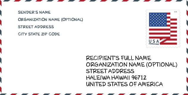
Envelope Example

This is an example of a US zip envelope. You can use a 5-digit zipcode or a detailed 9-digit zipcode to copy the mail in the following address format.
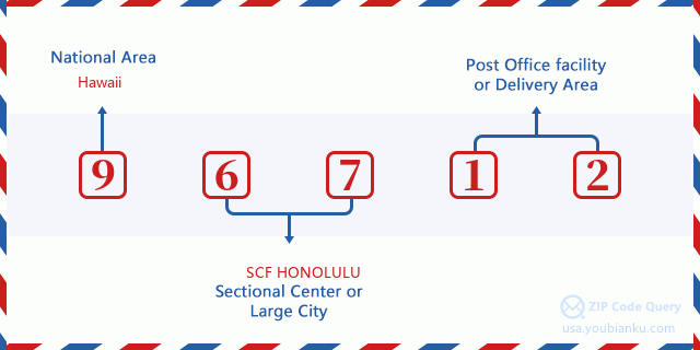
96712 Basic Meaning
What does each digit of ZIP Code 96712 stands for? The first digit designates a national area, which ranges from zero for the Northeast to nine for the far West. The 2-3 digits are the code of a sectional center facility in that region. The last two digits designate small post offices or postal zones.
Online Map

This is online map of the address Haleiwa, Hawaii, United States. You may use button to move and zoom in / out. The map information is for reference only.
Museum

This is the ZIP Code 96712 - Museum page list. Its detail Museum Name, Street, City, State, ZIP Code, Phone is as below.
| Name | Street | City | State | ZIP Code | Phone |
| WAIMEA VALLEY AUDUBON CENTER | 59-864 KAMEHAMEHA HIGHWAY | HALEIWA | HI | 96712 | (808) 638-9199 |
| NORTH SHORES SURF AND CULTURAL MUSEUM | 66-250 KAMEHAMEHA HWY | HALEIWA | HI | 96712 | (808) 637-8888 |
| WAIALUA NORTH SHORE HISTORICAL SOCIETY | 66 250 KAMEHAMEHA HWY | HALEIWA | HI | 96712 | |
| HIIPAKA (WAIMEA VALLEY) | 59-864 KAMEHAMEHA HWY | HALEIWA | HI | 96712 |
School

This is the ZIP Code 96712 - School page list. Its detail School Name, Address, City, State, ZIP Code is as below.
| School Name | Address | City | State | Grades | ZIP Code |
|---|---|---|---|---|---|
| Sunset Beach Elementary School | 59-360 Kamehameha Hwy | Haleiwa | HI | UG | 96712 |
| Haleiwa Elementary School | 66-505 Haleiwa Rd | Haleiwa | HI | UG | 96712 |
Population for ZIP Code 96712

What is the total population in ZIP Code 96712? Below is detail information.
- Population for ZIP Code 96712: 6,825
- 2010 Population: 7,352
The 2020 demographic statistics are in progress. The current population in ZIP code 96712 is 6,825, and the population in 2010 is 7,352.
Gender

In all the statistical population, the male population is 3,860, the female population is 3,492.
- Male Population: 3,860
- Female Population: 3,492
Race

In all the statistical population, the male population is 3,860, the female population is 3,492.
- White Population: 5,240
- Black Population: 107
- Hispanic Population: 716
- Asian Population: 2,344
- Hawaiian Population: 1,565
- Indian Population: 251
- Other Population: 262
Age

In all the statistical population, the White population is 5,240, the Black population is 107, the Hispanic population is 716, the Asian population is 2,344, the Hawaiian population is 1,565, the Indian Ppopulation is 251 and Other population is 262.
- Age's Median: 37.9
- Median of male age: 37.2
- Median of female age: 38.5
Households for ZIP Code 96712
ZIP code 96712 has 2,554 households, with an average number of 2.85 persons per household. The average income per household in Zip code 96712 is 89,241 USD, and the average house value is 1,112,800 USD.
- Households Per Zipcode: 2,554
- Persons Per Household: 2.85
- Average House Value: 1,112,800
- Income Per Household: 89,241
Geographic

The latitude of the Zip code 96712 is 21.605420, the longitude is -158.019089, and the elevation is 831. It has land area of 20.708 square miles, and water area of 4.747 square miles. The time zone for ZIP code 96712 is Hawaii-Aleutian Islands (GMT -10:00). Daylight saving time should be observed in the area where the zip code is located.
- Latitude: 21.605420
- Longitude: -158.019089
- Elevation: 831
- Land Area: 20.708
- Water Area: 4.747
- Time Zone: Hawaii-Aleutian Islands (GMT -10:00)
- Region: West
- Division: Pacific
- Day Light Saving: N
Congressional District

The Congressional District for ZIP code 96712 is Hawaii's 2nd congressional district, the Congressional Land Area is 6213.4 square mile.
- Congressional District: 2nd
- Congressional Land Area: 6213.4
Delivery

In the ZIP code 96712, there are 2,395 residential delivery mailboxes and centralized units, and 207 commercial delivery mailbox and centralized units, 2,225 single family deliveries and 117 multifamily deliveries, and the box count is 3,495. The main post office has city delivery carrier routes for the ZIP code 96712.
- Delivery Residential: 2,395
- Delivery Business: 207
- Delivery Total: 3,495
- Single Family Delivery Units: 2,225
- Multi Family Delivery Units: 117
- City Delivery Indicator: Y
Business

In ZIP code 96712, the number of business is 217, the number of employee is 1,944, the business first quarter payroll is 13,536,000 USD, the business annual payroll is 58,269,000 USD.
- Number Of Businesses: 217
- Number Of Employees: 1,944
- Business First Quarter Payroll: 13,536,000
- Business Annual Payroll: 58,269,000
Social Security Benefits

There are 1,235 beneficiaries with benefits in current-payment status for ZIP code 96712, of which 990 are retired workers, 80 are disabled workers, 70 are widow(er)s and parents, 45 are spouses and 50 are children. The number of beneficiaries aged 65 or older is 1,045. The total monthly benefits are 1,755,000 USD, of which 1,471,000 USD for retired workers, 102,000 USD for widow(er)s and parents.
- Total Number: 1,235
- Retired workers Number: 990
- Disabled workers Number: 80
- Widow(er)s and parents Number: 70
- Spouses Number: 45
- Children Number: 50
- All beneficiaries per month: 1,755,000
- Retired workers per month: 1,471,000
- Widow(er)s and parents per month: 102,000
- Number of beneficiaries aged 65 or older: 1,045


Add new comment