ZIP Code: 96797, Waipahu, HI
ZIP Code 96797 is located in Waipahu, Hawaii. Its detail State, County, City, Longitude, Latitude, Envelope Example, Population is as below.
, capturing its rich history and natural beauty, featuring a vintage postcard theme with a sugar mill, sugarcane fields, Hawaiian landscapes, and cultural details.")
ZIP Code 96797 Information

-
-
Country:
U.S. - United States
State:
County FIPS:
15003
County:
City:
Area Code:
City Type ?In many cases, a ZIP Code can have multiple "names", meaning cities, towns, or subdivisions, in its boundaries. However, it will ALWAYS have exactly 1 "default" name. D - Default - This is the "preferred" name - by the USPS - for a city. Each ZIP Code has one - and only one - "default" name. In most cases, this is what people who live in that area call the city as well. A - Acceptable - This name can be used for mailing purposes. Often times alternative names are large neighborhoods or sections of the city/town. In some cases a ZIP Code may have several "acceptable" names which is used to group towns under one ZIP Code. N - Not Acceptable - A "not acceptable" name is, in many cases, a nickname that residents give that location. According to the USPS, you should NOT send mail to that ZIP Code using the "not acceptable" name when mailing.:
D (Default)
ZIP Code:
96797
❓What does D (Default) mean? This is the "preferred" name - by the USPS - for a city. Each ZIP Code has one - and only one - "default" name. In most cases, this is what people who live in that area call the city as well.
ZIP Code 96797 Plus 4
ZIP Code 5 plus 4 is the extension of 5-digit zip code, It can be used to locate a more detailed location. The last four digits designate segment or one side of a street or an apartment. You can find the ZIP+4 code and corresponding address of the zip code 96797 below.
| ZIP Code 5 Plus 4 | Address |
|---|---|
| 96797-0001 | PO BOX 970001, WAIPAHU, HI |
| 96797-0121 | PO BOX 970121, WAIPAHU, HI |
| 96797-0241 | PO BOX 970241, WAIPAHU, HI |
| 96797-0361 | PO BOX 970361, WAIPAHU, HI |
| 96797-0481 | PO BOX 970481, WAIPAHU, HI |
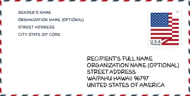
Envelope Example

This is an example of a US zip envelope. You can use a 5-digit zipcode or a detailed 9-digit zipcode to copy the mail in the following address format.
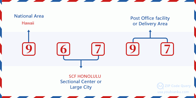
96797 Basic Meaning
What does each digit of ZIP Code 96797 stands for? The first digit designates a national area, which ranges from zero for the Northeast to nine for the far West. The 2-3 digits are the code of a sectional center facility in that region. The last two digits designate small post offices or postal zones.
Online Map

This is online map of the address Waipahu, Hawaii, United States. You may use button to move and zoom in / out. The map information is for reference only.
Museum

This is the ZIP Code 96797 - Museum page list. Its detail Museum Name, Street, City, State, ZIP Code, Phone is as below.
- Name: HAWAII'S PLANTATION VILLAGE
- Street: 94-695 WAIPAHU ST
- City: WAIPAHU
- State: HI
- ZIP Code: 96797
- Phone: (808) 677-0110
Library

This is the ZIP Code 96797 - Library page list. Its detail Library Name, Address, City, State, ZIP Code, Phone is as below.
- Name: WAIPAHU PUBLIC LIBRARY
- Address: 94-275 MOKUOLA STREET.
- City: WAIPAHU
- State: HI - Hawaii
- ZIP Code: 96797
- Phone: (808) 675-0358
School

This is the ZIP Code 96797 - School page list. Its detail School Name, Address, City, State, ZIP Code is as below.
| School Name | Address | City | State | Grades | ZIP Code |
|---|---|---|---|---|---|
| Honowai Elementary School | 94-600 Honowai St | Waipahu | HI | UG | 96797 |
| August Ahrens Elementary School | 94-1170 Waipahu St | Waipahu | HI | UG | 96797 |
| Waipahu Intermediate School | 94-455 Farrington Hwy | Waipahu | HI | UG | 96797 |
| Waipahu Elementary School | 94-465 Waipahu St | Waipahu | HI | UG | 96797 |
| Waipahu High School | 94-1211 Farrington Hwy | Waipahu | HI | UG | 96797 |
| Kanoelani Elementary School | 94-1091 Oli Lp | Waipahu | HI | UG | 96797 |
| Kaleiopuu Elementary School | 94-665 Kaaholo St | Waipahu | HI | UG | 96797 |
| Waikele Elementary School | 94-1035 Kukula St | Waipahu | HI | UG | 96797 |
| Hawaii Technology Academy - PCS | 94-450 Mokuola St | Waipahu | HI | UG | 96797 |
Population for ZIP Code 96797

What is the total population in ZIP Code 96797? Below is detail information.
- Population for ZIP Code 96797: 70,925
- 2010 Population: 72,289
The 2020 demographic statistics are in progress. The current population in ZIP code 96797 is 70,925, and the population in 2010 is 72,289.
Gender

In all the statistical population, the male population is 36,154, the female population is 36,135.
- Male Population: 36,154
- Female Population: 36,135
Race

In all the statistical population, the male population is 36,154, the female population is 36,135.
- White Population: 13,935
- Black Population: 1,822
- Hispanic Population: 4,922
- Asian Population: 55,984
- Hawaiian Population: 15,683
- Indian Population: 981
- Other Population: 1,543
Age

In all the statistical population, the White population is 13,935, the Black population is 1,822, the Hispanic population is 4,922, the Asian population is 55,984, the Hawaiian population is 15,683, the Indian Ppopulation is 981 and Other population is 1,543.
- Age's Median: 37.0
- Median of male age: 35.6
- Median of female age: 38.4
Households for ZIP Code 96797
ZIP code 96797 has 19,189 households, with an average number of 3.70 persons per household. The average income per household in Zip code 96797 is 90,993 USD, and the average house value is 581,800 USD.
- Households Per Zipcode: 19,189
- Persons Per Household: 3.70
- Average House Value: 581,800
- Income Per Household: 90,993
Geographic

The latitude of the Zip code 96797 is 21.414920, the longitude is -158.032948, and the elevation is 532. It has land area of 34.323 square miles, and water area of 1.856 square miles. The time zone for ZIP code 96797 is Hawaii-Aleutian Islands (GMT -10:00). Daylight saving time should be observed in the area where the zip code is located.
- Latitude: 21.414920
- Longitude: -158.032948
- Elevation: 532
- Land Area: 34.323
- Water Area: 1.856
- Time Zone: Hawaii-Aleutian Islands (GMT -10:00)
- Region: West
- Division: Pacific
- Day Light Saving: N
Congressional District

The Congressional District for ZIP code 96797 is Hawaii's 1st|2nd congressional district, the Congressional Land Area is 209.22|6213.4 square mile.
- Congressional District: 1st|2nd
- Congressional Land Area: 209.22|6213.4
Delivery

In the ZIP code 96797, there are 19,169 residential delivery mailboxes and centralized units, and 1,320 commercial delivery mailbox and centralized units, 11,466 single family deliveries and 3,005 multifamily deliveries, and the box count is 20,801. The main post office has city delivery carrier routes for the ZIP code 96797.
- Delivery Residential: 19,169
- Delivery Business: 1,320
- Delivery Total: 20,801
- Single Family Delivery Units: 11,466
- Multi Family Delivery Units: 3,005
- City Delivery Indicator: Y
Business

In ZIP code 96797, the number of business is 1,084, the number of employee is 18,098, the business first quarter payroll is 168,876,000 USD, the business annual payroll is 702,767,000 USD.
- Number Of Businesses: 1,084
- Number Of Employees: 18,098
- Business First Quarter Payroll: 168,876,000
- Business Annual Payroll: 702,767,000
Social Security Benefits

There are 13,425 beneficiaries with benefits in current-payment status for ZIP code 96797, of which 10,405 are retired workers, 980 are disabled workers, 765 are widow(er)s and parents, 510 are spouses and 765 are children. The number of beneficiaries aged 65 or older is 10,995. The total monthly benefits are 16,877,000 USD, of which 13,824,000 USD for retired workers, 892,000 USD for widow(er)s and parents.
- Total Number: 13,425
- Retired workers Number: 10,405
- Disabled workers Number: 980
- Widow(er)s and parents Number: 765
- Spouses Number: 510
- Children Number: 765
- All beneficiaries per month: 16,877,000
- Retired workers per month: 13,824,000
- Widow(er)s and parents per month: 892,000
- Number of beneficiaries aged 65 or older: 10,995


Add new comment