Postcode: 02601, Hyannis, MA
Postcode 02601 bevindt zich in Hyannis, Massachusetts. Het detail staat, provincie, stad, lengtegraad, breedtegraad, envelop Voorbeeld, Bevolking is zoals hieronder.

Postcode 02601 Informatie

-
-
Land:
U.S. - Verenigde Staten
Staat:
Regio FIPS:
25001
Graafschap:
Stad:
Stadtype ?In many cases, a ZIP Code can have multiple "names", meaning cities, towns, or subdivisions, in its boundaries. However, it will ALWAYS have exactly 1 "default" name. D - Default - This is the "preferred" name - by the USPS - for a city. Each ZIP Code has one - and only one - "default" name. In most cases, this is what people who live in that area call the city as well. A - Acceptable - This name can be used for mailing purposes. Often times alternative names are large neighborhoods or sections of the city/town. In some cases a ZIP Code may have several "acceptable" names which is used to group towns under one ZIP Code. N - Not Acceptable - A "not acceptable" name is, in many cases, a nickname that residents give that location. According to the USPS, you should NOT send mail to that ZIP Code using the "not acceptable" name when mailing.:
D (Default)
Postcode:
02601
❓Wat betekent D (Default)? Dit is de "geprefereerde" naam - door de USPS - voor een stad. Elke postcode heeft één - en slechts één - "standaard" naam. In de meeste gevallen noemen mensen die in dat gebied wonen de stad ook.
Postcode 02601 Plus 4
ZIP Code 5 plus 4 is de uitbreiding van de 5-cijferige postcode, het kan worden gebruikt om een meer gedetailleerde locatie te vinden. De laatste vier cijfers duiden een segment of een kant van een straat of een appartement aan. Hieronder vindt u de postcode en het bijbehorende adres van de postcode 02601.
| Postcode 5 Plus 4 | Adres |
|---|---|
| 02601-0001 | PO BOX 1, HYANNIS, MA |
| 02601-0151 | PO BOX 151, HYANNIS, MA |
| 02601-0211 | PO BOX 211, HYANNIS, MA |
| 02601-0331 | PO BOX 331, HYANNIS, MA |
| 02601-0451 | PO BOX 451, HYANNIS, MA |
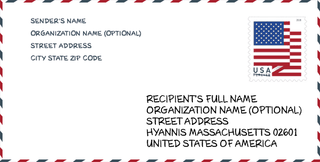
Envelop Voorbeeld

Dit is een voorbeeld van een Amerikaanse postenvelop. U kunt een 5-cijferige postcode of een gedetailleerde 9-cijferige postcode gebruiken om de mail in het volgende adresformaat te kopiëren.
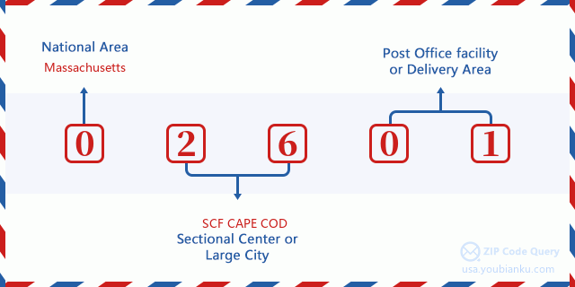
02601 Basisbetekenis
Waar staat elk cijfer van postcode 02601 voor? Het eerste cijfer geeft een nationaal gebied aan, dat varieert van nul voor het noordoosten tot negen voor het verre westen. De 2-3 cijfers zijn de code van een sectiecentrumfaciliteit in die regio. De laatste twee cijfers duiden kleine postkantoren of postzones aan.
Online landkaart

Het is een online kaart van adres Hyannis, Massachusetts, United States. U kunt Knopje gebruiken te in/uitzoomen. De kaartinformatie is alleen ter referentie.
Universiteit

This is the ZIP Code 02601 - University page list. Its detail university Name, Street, City, State, ZIP Code, Phone is as below.
| Naam | Straat | Stad | Staat | Postcode | Telefoon |
| Empire Beauty School-Hyannis | 259 North Street | Hyannis | MA | 02601 | - |
Ziekenhuis

Het is de Postcode 02601 - Ziekenhuis pagina lijst. Het detail Ziekenhuisnaam, straat, stad, staat, postcode, telefoon is zoals hieronder.
- Naam: CAPE COD HEALTHCARE
- Adres: HYANNIS
- Stad: 88 LEWIS BAY ROAD
- Staat: MA
- Postcode: 02601
- Telefoon: (508) 771-1800
Museum

Dit is de paginalijst van Postcode 02601 - Museum. Hieronder is het detail van Museum Naam, Straat, Stad, Staat, Postcode, Telefoon.
- Naam: TOAD HALL CLASSIC CAR MUSEUM
- Straat: 288 SCUDDER AVE
- Stad: HYANNIS
- Staat: MA
- Postcode: 02601
- Telefoon: (508) 778-4934
Bibliotheek

Dit is de paginalijst van Postcode 02601 - Bibliotheek. Hieronder is het detail van Bibliotheek Naam, Adres, Stad, Staat, Postcode, Telefoon.
- Naam: HYANNIS PUBLIC LIBRARY ASSOC.
- Adres: 401 MAIN ST.
- Stad: HYANNIS
- Staat: MA - Massachusetts
- Postcode: 02601
- Telefoon: (508) 775-2280
School
Dit is de paginalijst van Postcode 02601 - School. Hieronder is het detail van School Naam, Adres, Stad, Staat, Postcode.
| School Naam | Adres | Stad | Staat | Klassen | Postcode |
|---|---|---|---|---|---|
| Sturgis Charter Public School | 427 Main Street | Hyannis | MA | UG | 02601 |
| Barnstable High | 744 West Main Street | Hyannis | MA | UG | 02601 |
| Hyannis West Elementary | 549 West Main Street | Hyannis | MA | UG | 02601 |
| Barnstable Intermediate School | 895 Falmouth Road | Hyannis | MA | UG | 02601 |
| Enoch Cobb Early Learning Center | 50 Old Craigville Road | Hyannis | MA | UG | 02601 |
| Barnstable Community Innovation School | 165 Bearses Way | Hyannis | MA | UG | 02601 |
Population for Postcode 02601

What is the total population in ZIP Code 02601? Below is detail information.
- Population for Postcode 02601: 17,026
- 2010 Bevolking: 14,089
The 2020 demographic statistics are in progress. The current population in ZIP code 02601 is 17,026, and the population in 2010 is 14,089.
Geslacht

In all the statistical population, the male population is 6,922, the female population is 7,167.
- Male Population: 6,922
- Female Population: 7,167
Race

In all the statistical population, the male population is 6,922, the female population is 7,167.
- White Population: 11,611
- Black Population: 1,330
- Hispanic Population: 898
- Asian Population: 363
- Hawaiian Population: 27
- Indian Population: 377
- Other Population: 1,300
Leeftijd

In all the statistical population, the White population is 11,611, the Black population is 1,330, the Hispanic population is 898, the Asian population is 363, the Hawaiian population is 27, the Indian Ppopulation is 377 and Other population is 1,300.
- Age's Median: 41.7
- Median of male age: 39.7
- Median of female age: 43.3
Households for Postcode 02601
ZIP code 02601 has 6,130 households, with an average number of 2.24 persons per household. The average income per household in Zip code 02601 is 49,031 USD, and the average house value is 258,700 USD.
- Households Per Zipcode: 6,130
- Personen per huishouden: 2.24
- Gemiddelde huiswaarde: 258,700
- Inkomen per huishouden: 49,031
Geographic

The latitude of the Zip code 02601 is 41.656828, the longitude is -70.293756, and the elevation is 36. It has land area of 8.594 square miles, and water area of 0.831 square miles. The time zone for ZIP code 02601 is Eastern (GMT -05:00). Daylight saving time should be observed in the area where the zip code is located.
- Breedtegraad: 41.656828
- Lengte: -70.293756
- Elevatie: 36
- Landoppervlak: 8.594
- Water Area: 0.831
- Tijd Zone: Eastern (GMT -05:00)
- Regio: Northeast
- Divisie: New England
- Zomertijd: Y
congresdistrict

The Congressional District for ZIP code 02601 is Massachusetts's 09th congressional district, the Congressional Land Area is 1214.74 square mile.
- congresdistrict: 09th
- Congresgebied: 1214.74
Levering

In the ZIP code 02601, there are 7,601 residential delivery mailboxes and centralized units, and 1,601 commercial delivery mailbox and centralized units, 5,196 single family deliveries and 1,239 multifamily deliveries, and the box count is 9,830. The main post office has city delivery carrier routes for the ZIP code 02601.
- Delivery Residential: 7,601
- Delivery Business: 1,601
- Delivery Total: 9,830
- Leveringseenheden voor één gezin: 5,196
- Multi Family Delivery Units: 1,239
- Stadsleveringsindicator: Y
Bedrijf

In ZIP code 02601, the number of business is 1,226, the number of employee is 20,612, the business first quarter payroll is 244,082,000 USD, the business annual payroll is 1,035,508,000 USD.
- Number Of Businesses: 1,226
- Number Of Employees: 20,612
- Zakelijke salarisadministratie eerste kwartaal: 244,082,000
- Zakelijke jaarlijkse loonlijst: 1,035,508,000


Reactie toevoegen