ZIP Code: 02601, Hyannis, MA
ZIP Code 02601 is located in Hyannis, Massachusetts. Its detail State, County, City, Longitude, Latitude, Envelope Example, Population is as below.

ZIP Code 02601 Information

-
-
Country:
U.S. - United States
State:
County FIPS:
25001
City:
City Type ?In many cases, a ZIP Code can have multiple "names", meaning cities, towns, or subdivisions, in its boundaries. However, it will ALWAYS have exactly 1 "default" name. D - Default - This is the "preferred" name - by the USPS - for a city. Each ZIP Code has one - and only one - "default" name. In most cases, this is what people who live in that area call the city as well. A - Acceptable - This name can be used for mailing purposes. Often times alternative names are large neighborhoods or sections of the city/town. In some cases a ZIP Code may have several "acceptable" names which is used to group towns under one ZIP Code. N - Not Acceptable - A "not acceptable" name is, in many cases, a nickname that residents give that location. According to the USPS, you should NOT send mail to that ZIP Code using the "not acceptable" name when mailing.:
D (Default)
ZIP Code:
02601
❓What does D (Default) mean? This is the "preferred" name - by the USPS - for a city. Each ZIP Code has one - and only one - "default" name. In most cases, this is what people who live in that area call the city as well.
ZIP Code 02601 Plus 4
ZIP Code 5 plus 4 is the extension of 5-digit zip code, It can be used to locate a more detailed location. The last four digits designate segment or one side of a street or an apartment. You can find the ZIP+4 code and corresponding address of the zip code 02601 below.
| ZIP Code 5 Plus 4 | Address |
|---|---|
| 02601-0001 | PO BOX 1, HYANNIS, MA |
| 02601-0151 | PO BOX 151, HYANNIS, MA |
| 02601-0211 | PO BOX 211, HYANNIS, MA |
| 02601-0331 | PO BOX 331, HYANNIS, MA |
| 02601-0451 | PO BOX 451, HYANNIS, MA |
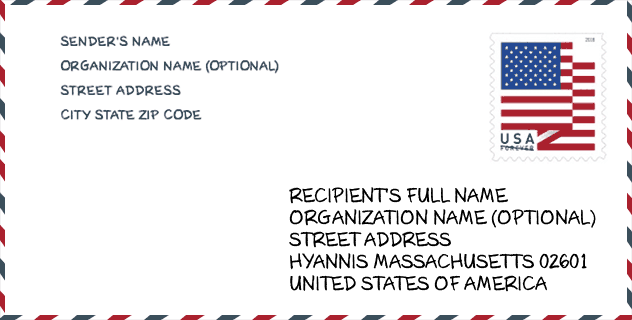
Envelope Example

This is an example of a US zip envelope. You can use a 5-digit zipcode or a detailed 9-digit zipcode to copy the mail in the following address format.
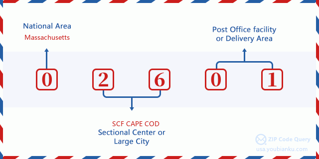
02601 Basic Meaning
What does each digit of ZIP Code 02601 stands for? The first digit designates a national area, which ranges from zero for the Northeast to nine for the far West. The 2-3 digits are the code of a sectional center facility in that region. The last two digits designate small post offices or postal zones.
Online Map

This is online map of the address Hyannis, Massachusetts, United States. You may use button to move and zoom in / out. The map information is for reference only.
University

This is the ZIP Code 02601 - University page list. Its detail university Name, Street, City, State, ZIP Code, Phone is as below.
| Name | Street | City | State | ZIP Code | Phone |
| Empire Beauty School-Hyannis | 259 North Street | Hyannis | MA | 02601 | - |
Hospital

This is the ZIP Code 02601 - Hospital page list. Its detail Hospital Name, Street, City, State, ZIP Code, Phone is as below.
- Name: CAPE COD HEALTHCARE
- Address: HYANNIS
- City: 88 LEWIS BAY ROAD
- State: MA
- ZIP Code: 02601
- Phone: (508) 771-1800
Museum

This is the ZIP Code 02601 - Museum page list. Its detail Museum Name, Street, City, State, ZIP Code, Phone is as below.
- Name: TOAD HALL CLASSIC CAR MUSEUM
- Street: 288 SCUDDER AVE
- City: HYANNIS
- State: MA
- ZIP Code: 02601
- Phone: (508) 778-4934
Library

This is the ZIP Code 02601 - Library page list. Its detail Library Name, Address, City, State, ZIP Code, Phone is as below.
- Name: HYANNIS PUBLIC LIBRARY ASSOC.
- Address: 401 MAIN ST.
- City: HYANNIS
- State: MA - Massachusetts
- ZIP Code: 02601
- Phone: (508) 775-2280
School
This is the ZIP Code 02601 - School page list. Its detail School Name, Address, City, State, ZIP Code is as below.
| School Name | Address | City | State | Grades | ZIP Code |
|---|---|---|---|---|---|
| Sturgis Charter Public School | 427 Main Street | Hyannis | MA | UG | 02601 |
| Barnstable High | 744 West Main Street | Hyannis | MA | UG | 02601 |
| Hyannis West Elementary | 549 West Main Street | Hyannis | MA | UG | 02601 |
| Barnstable Intermediate School | 895 Falmouth Road | Hyannis | MA | UG | 02601 |
| Enoch Cobb Early Learning Center | 50 Old Craigville Road | Hyannis | MA | UG | 02601 |
| Barnstable Community Innovation School | 165 Bearses Way | Hyannis | MA | UG | 02601 |
Population for ZIP Code 02601

What is the total population in ZIP Code 02601? Below is detail information.
- Population for ZIP Code 02601: 17,026
- 2010 Population: 14,089
The 2020 demographic statistics are in progress. The current population in ZIP code 02601 is 17,026, and the population in 2010 is 14,089.
Gender

In all the statistical population, the male population is 6,922, the female population is 7,167.
- Male Population: 6,922
- Female Population: 7,167
Race

In all the statistical population, the male population is 6,922, the female population is 7,167.
- White Population: 11,611
- Black Population: 1,330
- Hispanic Population: 898
- Asian Population: 363
- Hawaiian Population: 27
- Indian Population: 377
- Other Population: 1,300
Age

In all the statistical population, the White population is 11,611, the Black population is 1,330, the Hispanic population is 898, the Asian population is 363, the Hawaiian population is 27, the Indian Ppopulation is 377 and Other population is 1,300.
- Age's Median: 41.7
- Median of male age: 39.7
- Median of female age: 43.3
Households for ZIP Code 02601
ZIP code 02601 has 6,130 households, with an average number of 2.24 persons per household. The average income per household in Zip code 02601 is 49,031 USD, and the average house value is 258,700 USD.
- Households Per Zipcode: 6,130
- Persons Per Household: 2.24
- Average House Value: 258,700
- Income Per Household: 49,031
Geographic

The latitude of the Zip code 02601 is 41.656828, the longitude is -70.293756, and the elevation is 36. It has land area of 8.594 square miles, and water area of 0.831 square miles. The time zone for ZIP code 02601 is Eastern (GMT -05:00). Daylight saving time should be observed in the area where the zip code is located.
- Latitude: 41.656828
- Longitude: -70.293756
- Elevation: 36
- Land Area: 8.594
- Water Area: 0.831
- Time Zone: Eastern (GMT -05:00)
- Region: Northeast
- Division: New England
- Day Light Saving: Y
Congressional District

The Congressional District for ZIP code 02601 is Massachusetts's 09th congressional district, the Congressional Land Area is 1214.74 square mile.
- Congressional District: 09th
- Congressional Land Area: 1214.74
Delivery

In the ZIP code 02601, there are 7,601 residential delivery mailboxes and centralized units, and 1,601 commercial delivery mailbox and centralized units, 5,196 single family deliveries and 1,239 multifamily deliveries, and the box count is 9,830. The main post office has city delivery carrier routes for the ZIP code 02601.
- Delivery Residential: 7,601
- Delivery Business: 1,601
- Delivery Total: 9,830
- Single Family Delivery Units: 5,196
- Multi Family Delivery Units: 1,239
- City Delivery Indicator: Y
Business

In ZIP code 02601, the number of business is 1,226, the number of employee is 20,612, the business first quarter payroll is 244,082,000 USD, the business annual payroll is 1,035,508,000 USD.
- Number Of Businesses: 1,226
- Number Of Employees: 20,612
- Business First Quarter Payroll: 244,082,000
- Business Annual Payroll: 1,035,508,000


Add new comment