Postcode: 04039, Gray, ME
Postcode 04039 bevindt zich in Gray, Maine. Het detail staat, provincie, stad, lengtegraad, breedtegraad, envelop Voorbeeld, Bevolking is zoals hieronder.
 depicting retro airmail envelope with '04039' ZIP code and symbolic portrayal of the first woolen mill in America, symbolizing Gray's historical significance. Includes Maine state flag elements - a moose under a tall pine tree, farmer and sailor representing state's traditional reliance on agriculture and sea, topped with the state motto 'I Lead' North Star. Cleverly integrates elements symbolizing Cumberland County cultural heritage like local landmarks or unique human-made cultural features. Adorned with a typical American postage stamp and postmark, enhancing postal theme. Vibrant and modern illustration designed for web use, capturing the essence of the region's history, culture, and postal identity.")
Postcode 04039 Informatie

-
-
Land:
U.S. - Verenigde Staten
Staat:
Regio FIPS:
23005
Graafschap:
Stad:
Netnummer:
Stadtype ?In many cases, a ZIP Code can have multiple "names", meaning cities, towns, or subdivisions, in its boundaries. However, it will ALWAYS have exactly 1 "default" name. D - Default - This is the "preferred" name - by the USPS - for a city. Each ZIP Code has one - and only one - "default" name. In most cases, this is what people who live in that area call the city as well. A - Acceptable - This name can be used for mailing purposes. Often times alternative names are large neighborhoods or sections of the city/town. In some cases a ZIP Code may have several "acceptable" names which is used to group towns under one ZIP Code. N - Not Acceptable - A "not acceptable" name is, in many cases, a nickname that residents give that location. According to the USPS, you should NOT send mail to that ZIP Code using the "not acceptable" name when mailing.:
D (Default)
Postcode:
04039
❓Wat betekent D (Default)? Dit is de "geprefereerde" naam - door de USPS - voor een stad. Elke postcode heeft één - en slechts één - "standaard" naam. In de meeste gevallen noemen mensen die in dat gebied wonen de stad ook.
Postcode 04039 Plus 4
ZIP Code 5 plus 4 is de uitbreiding van de 5-cijferige postcode, het kan worden gebruikt om een meer gedetailleerde locatie te vinden. De laatste vier cijfers duiden een segment of een kant van een straat of een appartement aan. Hieronder vindt u de postcode en het bijbehorende adres van de postcode 04039.
| Postcode 5 Plus 4 | Adres |
|---|---|
| 04039-0001 | PO BOX 1, GRAY, ME |
| 04039-0121 | PO BOX 121, GRAY, ME |
| 04039-0135 | 1301 BRALEAD RD, GRAY, ME |
| 04039-0141 | PO BOX 141, GRAY, ME |
| 04039-0241 | PO BOX 241, GRAY, ME |
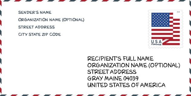
Envelop Voorbeeld

Dit is een voorbeeld van een Amerikaanse postenvelop. U kunt een 5-cijferige postcode of een gedetailleerde 9-cijferige postcode gebruiken om de mail in het volgende adresformaat te kopiëren.
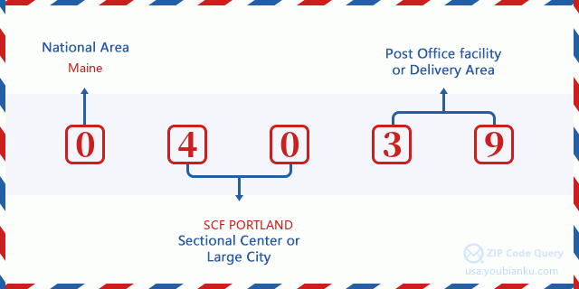
04039 Basisbetekenis
Waar staat elk cijfer van postcode 04039 voor? Het eerste cijfer geeft een nationaal gebied aan, dat varieert van nul voor het noordoosten tot negen voor het verre westen. De 2-3 cijfers zijn de code van een sectiecentrumfaciliteit in die regio. De laatste twee cijfers duiden kleine postkantoren of postzones aan.
Online landkaart

Het is een online kaart van adres Gray, Maine, United States. U kunt Knopje gebruiken te in/uitzoomen. De kaartinformatie is alleen ter referentie.
Bibliotheek

Dit is de paginalijst van Postcode 04039 - Bibliotheek. Hieronder is het detail van Bibliotheek Naam, Adres, Stad, Staat, Postcode, Telefoon.
- Naam: GRAY PUBLIC LIBRARY
- Adres: 5 HANCOCK STREET
- Stad: GRAY
- Staat: ME - Maine
- Postcode: 04039
- Telefoon: (207) 657-4110
School

Dit is de paginalijst van Postcode 04039 - School. Hieronder is het detail van School Naam, Adres, Stad, Staat, Postcode.
| School Naam | Adres | Stad | Staat | Klassen | Postcode |
|---|---|---|---|---|---|
| Gray-New Gloucester High School | 10 Libby Hill Road | Gray | ME | UG | 04039 |
| Russell School | 8 Gray Park | Gray | ME | UG | 04039 |
| Gray-New Gloucester Middle School | 31 Libby Hill Road | Gray | ME | UG | 04039 |
| Fiddlehead School of Arts & Science | 25 Shaker Rd | Gray | ME | UG | 04039 |
Population for Postcode 04039

What is the total population in ZIP Code 04039? Below is detail information.
- Population for Postcode 04039: 7,884
- 2010 Bevolking: 7,422
The 2020 demographic statistics are in progress. The current population in ZIP code 04039 is 7,884, and the population in 2010 is 7,422.
Geslacht

In all the statistical population, the male population is 3,691, the female population is 3,731.
- Male Population: 3,691
- Female Population: 3,731
Race

In all the statistical population, the male population is 3,691, the female population is 3,731.
- White Population: 7,296
- Black Population: 82
- Hispanic Population: 65
- Asian Population: 54
- Hawaiian Population: 8
- Indian Population: 58
- Other Population: 20
Leeftijd

In all the statistical population, the White population is 7,296, the Black population is 82, the Hispanic population is 65, the Asian population is 54, the Hawaiian population is 8, the Indian Ppopulation is 58 and Other population is 20.
- Age's Median: 40.2
- Median of male age: 39.8
- Median of female age: 40.7
Households for Postcode 04039
ZIP code 04039 has 3,008 households, with an average number of 2.47 persons per household. The average income per household in Zip code 04039 is 71,855 USD, and the average house value is 220,000 USD.
- Households Per Zipcode: 3,008
- Personen per huishouden: 2.47
- Gemiddelde huiswaarde: 220,000
- Inkomen per huishouden: 71,855
Geographic

The latitude of the Zip code 04039 is 43.887580, the longitude is -70.341074, and the elevation is 247. It has land area of 40.66 square miles, and water area of 0.927 square miles. The time zone for ZIP code 04039 is Eastern (GMT -05:00). Daylight saving time should be observed in the area where the zip code is located.
- Breedtegraad: 43.887580
- Lengte: -70.341074
- Elevatie: 247
- Landoppervlak: 40.66
- Water Area: 0.927
- Tijd Zone: Eastern (GMT -05:00)
- Regio: Northeast
- Divisie: New England
- Zomertijd: Y
congresdistrict

The Congressional District for ZIP code 04039 is Maine's 1st congressional district, the Congressional Land Area is 3285.52 square mile.
- congresdistrict: 1st
- Congresgebied: 3285.52
Levering

In the ZIP code 04039, there are 3,192 residential delivery mailboxes and centralized units, and 120 commercial delivery mailbox and centralized units, 2,636 single family deliveries and 43 multifamily deliveries, and the box count is 5,019. The main post office does not have city delivery carrier routes for the ZIP code 04039.
- Delivery Residential: 3,192
- Delivery Business: 120
- Delivery Total: 5,019
- Leveringseenheden voor één gezin: 2,636
- Multi Family Delivery Units: 43
- Stadsleveringsindicator: N
Bedrijf

In ZIP code 04039, the number of business is 233, the number of employee is 1,609, the business first quarter payroll is 13,530,000 USD, the business annual payroll is 60,362,000 USD.
- Number Of Businesses: 233
- Number Of Employees: 1,609
- Zakelijke salarisadministratie eerste kwartaal: 13,530,000
- Zakelijke jaarlijkse loonlijst: 60,362,000


Reactie toevoegen