Verenigde Staten Postcode: 10467
Dit is de paginalijst van New York Postcode 10467. Hieronder is het detail van Staat, Graafschap, Stad, Lengte, Breedtegraad, Envelop Voorbeeld, Bevolking.

Postcode 10467 Informatie

-
-
Land:
U.S. - Verenigde Staten
Staat:
Staat FIPS:
36
Postcode:
10467
Postcode Type:
S (Standard)
❓Wat betekent S (Standard)? Een "standaard" postcode is waar de meeste mensen aan denken als ze het over postcodes hebben - in wezen een stad, een stad of een afdeling van een stad die een postdienst heeft.
Postcode 10467 - Stad

Dit is de stadsinformatie die overeenkomt met 10467:
| Staat | Graafschap | Stad | Stadtype ?In many cases, a ZIP Code can have multiple "names", meaning cities, towns, or subdivisions, in its boundaries. However, it will ALWAYS have exactly 1 "default" name. D - Default - This is the "preferred" name - by the USPS - for a city. Each ZIP Code has one - and only one - "default" name. In most cases, this is what people who live in that area call the city as well. A - Acceptable - This name can be used for mailing purposes. Often times alternative names are large neighborhoods or sections of the city/town. In some cases a ZIP Code may have several "acceptable" names which is used to group towns under one ZIP Code. N - Not Acceptable - A "not acceptable" name is, in many cases, a nickname that residents give that location. According to the USPS, you should NOT send mail to that ZIP Code using the "not acceptable" name when mailing. | Postcode |
|---|---|---|---|---|
| NY | Bronx | Allerton | N (Not Acceptable) | 10467 |
| NY | Bronx | Bronx | D (Default) | 10467 |
| NY | Bronx | Mosholu | N (Not Acceptable) | 10467 |
| NY | Bronx | Van Cott | N (Not Acceptable) | 10467 |
| NY | Bronx | Williamsbridge | N (Not Acceptable) | 10467 |
❓Wat betekent D (Default)? Dit is de "geprefereerde" naam - door de USPS - voor een stad. Elke postcode heeft één - en slechts één - "standaard" naam. In de meeste gevallen noemen mensen die in dat gebied wonen de stad ook.
❓Wat betekent N (Not Acceptable)? Een "niet acceptabele" naam is in veel gevallen een bijnaam die bewoners aan die locatie geven. Volgens de USPS mag je GEEN post naar die postcode sturen met de "niet acceptabele" naam bij het mailen.
Postcode 10467 Plus 4
ZIP Code 5 plus 4 is de uitbreiding van de 5-cijferige postcode, het kan worden gebruikt om een meer gedetailleerde locatie te vinden. De laatste vier cijfers duiden een segment of een kant van een straat of een appartement aan. Hieronder vindt u de postcode en het bijbehorende adres van de postcode 10467.
| Postcode 5 Plus 4 | Adres |
|---|---|
| 10467-0001 | PO BOX 1, BRONX, NY |
| 10467-0061 | PO BOX 61, BRONX, NY |
| 10467-0121 | PO BOX 121, BRONX, NY |
| 10467-0181 | PO BOX 181, BRONX, NY |
| 10467-0241 | PO BOX 241, BRONX, NY |
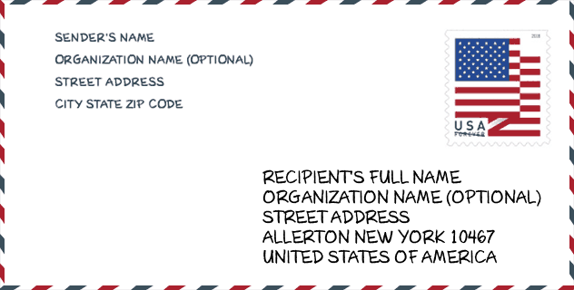
Envelop Voorbeeld

Dit is een voorbeeld van een Amerikaanse postenvelop. U kunt een 5-cijferige postcode of een gedetailleerde 9-cijferige postcode gebruiken om de mail in het volgende adresformaat te kopiëren.
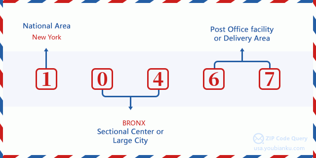
10467 Basisbetekenis
Waar staat elk cijfer van postcode 10467 voor? Het eerste cijfer geeft een nationaal gebied aan, dat varieert van nul voor het noordoosten tot negen voor het verre westen. De 2-3 cijfers zijn de code van een sectiecentrumfaciliteit in die regio. De laatste twee cijfers duiden kleine postkantoren of postzones aan.
Online landkaart

Het is een online kaart van adres Williamsbridge, New York, United States. U kunt Knopje gebruiken te in/uitzoomen. De kaartinformatie is alleen ter referentie.
Ziekenhuis

Het is de Postcode 10467 - Ziekenhuis pagina lijst. Het detail Ziekenhuisnaam, straat, stad, staat, postcode, telefoon is zoals hieronder.
| Naam | Adres | Stad | Staat | Postcode | Telefoon |
|---|---|---|---|---|---|
| MONTEFIORE MEDICAL CENTER | 111 EAST 210TH STREET | BRONX | NY | 10467 | (718) 920-4321 |
| NORTH CENTRAL BRONX HOSPITAL | 3424 KOSSUTH AVENUE & 210TH STREET | BRONX | NY | 10467 | (212) 519-5000 |
Museum

Dit is de paginalijst van Postcode 10467 - Museum. Hieronder is het detail van Museum Naam, Straat, Stad, Staat, Postcode, Telefoon.
- Naam: VALENTINE-VARIAN HOUSE
- Straat: 3266 BAINBRIDGE AVE
- Stad: BRONX
- Staat: NY
- Postcode: 10467
- Telefoon: (718) 881-8900
Bibliotheek

Dit is de paginalijst van Postcode 10467 - Bibliotheek. Hieronder is het detail van Bibliotheek Naam, Adres, Stad, Staat, Postcode, Telefoon.
| Naam | Adres | Stad | Staat | Postcode | Telefoon |
|---|---|---|---|---|---|
| ALLERTON BRANCH | 2740 BARNES AVENUE | BRONX | NY | 10467 | (718) 881-4240 |
| MOSHOLU BRANCH | 285 EAST 205TH STREET | BRONX | NY | 10467 | (718) 882-8239 |
School

Dit is de paginalijst van Postcode 10467 - School. Hieronder is het detail van School Naam, Adres, Stad, Staat, Postcode.
| School Naam | Adres | Stad | Staat | Klassen | Postcode |
|---|---|---|---|---|---|
| PS 56 NORWOOD HEIGHTS | 341 E 207TH ST | BRONX | NY | UG | 10467 |
| PS/MS 280 MOSHOLU PARKWAY | 3202 STEUBEN AVE | BRONX | NY | UG | 10467 |
| BRONX DANCE ACADEMY SCHOOL | 3617 BAINBRIDGE AVE | BRONX | NY | UG | 10467 |
| BEDFORD PARK ELEMENTARY SCHOOL | 3177 WEBSTER AVE | BRONX | NY | UG | 10467 |
| PS 96 RICHARD RODGERS | 2385 OLINVILLE AVE | BRONX | NY | UG | 10467 |
| HIGH SCHOOL FOR CONTEMPORARY ARTS | 800 E GUN HILL RD | BRONX | NY | UG | 10467 |
| BRONX AEROSPACE HIGH SCHOOL | 800 E GUN HILL RD | BRONX | NY | UG | 10467 |
| BRONX HIGH SCHOOL FOR WRITING AND COMMUNICATION ARTS | 800 E GUN HILL RD | BRONX | NY | UG | 10467 |
| BRONX LAB SCHOOL | 800 E GUN HILL RD | BRONX | NY | UG | 10467 |
| HIGH SCHOOL OF COMPUTERS AND TECHNOLOGY | 800 E GUN HILL RD | BRONX | NY | UG | 10467 |
| BRONX ACADEMY OF HEALTH CAREERS | 800 E GUN HILL RD | BRONX | NY | UG | 10467 |
| NORTH BRONX SCHOOL OF EMPOWERMENT | 3710 BARNES AVE | BRONX | NY | UG | 10467 |
| BRONX GREEN MIDDLE SCHOOL | 2441 WALLACE AVE | BRONX | NY | UG | 10467 |
| LEADERS OF TOMORROW | 3710 BARNES AVE | BRONX | NY | UG | 10467 |
| PELHAM ACADEMY OF ACADEMICS AND COMMUNITY ENGAGEMENT | 2441 WALLACE AVE | BRONX | NY | UG | 10467 |
| BRONX PARK MIDDLE SCHOOL | 2441 WALLACE AVE | BRONX | NY | UG | 10467 |
| PS 168 | 3050 WEBSTER AVE | BRONX | NY | UG | 10467 |
| PS 469-BRONX SCHOOL FOR CONTINUOUS LEARNING (THE) | 3177 WEBSTER AVE | BRONX | NY | UG | 10467 |
| BRONX COMMUNITY CHARTER SCHOOL | 3170 WEBSTER AVE | BRONX | NY | UG | 10467 |
Population for Postcode 10467

What is the total population in ZIP Code 10467? Below is detail information.
- Population for Postcode 10467: 96,324
- 2010 Bevolking: 97,060
The 2020 demographic statistics are in progress. The current population in ZIP code 10467 is 96,324, and the population in 2010 is 97,060.
Geslacht

In all the statistical population, the male population is 45,318, the female population is 51,742.
- Male Population: 45,318
- Female Population: 51,742
Race

In all the statistical population, the male population is 45,318, the female population is 51,742.
- White Population: 28,615
- Black Population: 40,260
- Hispanic Population: 46,661
- Asian Population: 7,032
- Hawaiian Population: 440
- Indian Population: 2,043
- Other Population: 23,955
Leeftijd

In all the statistical population, the White population is 28,615, the Black population is 40,260, the Hispanic population is 46,661, the Asian population is 7,032, the Hawaiian population is 440, the Indian Ppopulation is 2,043 and Other population is 23,955.
- Age's Median: 32.8
- Median of male age: 31.1
- Median of female age: 34.2
Households for Postcode 10467
ZIP code 10467 has 35,524 households, with an average number of 2.68 persons per household. The average income per household in Zip code 10467 is 37,015 USD, and the average house value is 335,400 USD.
- Households Per Zipcode: 35,524
- Personen per huishouden: 2.68
- Gemiddelde huiswaarde: 335,400
- Inkomen per huishouden: 37,015
Geographic

The latitude of the Zip code 10467 is 40.876653, the longitude is -73.871508, and the elevation is 72. It has land area of 2.336 square miles, and water area of 0 square miles. The time zone for ZIP code 10467 is Eastern (GMT -05:00). Daylight saving time should be observed in the area where the zip code is located.
- Breedtegraad: 40.876653
- Lengte: -73.871508
- Elevatie: 72
- Landoppervlak: 2.336
- Water Area: 0
- Tijd Zone: Eastern (GMT -05:00)
- Regio: Northeast
- Divisie: Middle Atlantic
- Zomertijd: Y
congresdistrict

The Congressional District for ZIP code 10467 is New York's 13th|14th|16th congressional district, the Congressional Land Area is 10.25|28.29|78.37 square mile.
- congresdistrict: 13th|14th|16th
- Congresgebied: 10.25|28.29|78.37
Levering

In the ZIP code 10467, there are 35,942 residential delivery mailboxes and centralized units, and 1,458 commercial delivery mailbox and centralized units, 3,628 single family deliveries and 31,554 multifamily deliveries, and the box count is 39,808. The main post office has city delivery carrier routes for the ZIP code 10467.
- Delivery Residential: 35,942
- Delivery Business: 1,458
- Delivery Total: 39,808
- Leveringseenheden voor één gezin: 3,628
- Multi Family Delivery Units: 31,554
- Stadsleveringsindicator: Y
Bedrijf

In ZIP code 10467, the number of business is 1,136, the number of employee is 29,624, the business first quarter payroll is 516,028,000 USD, the business annual payroll is 2,129,604,000 USD.
- Number Of Businesses: 1,136
- Number Of Employees: 29,624
- Zakelijke salarisadministratie eerste kwartaal: 516,028,000
- Zakelijke jaarlijkse loonlijst: 2,129,604,000
Sociale zekerheid

Er zijn 13,230 begunstigden met uitkeringen in de huidige betalingsstatus voor postcode 10467, waarvan 7,990 gepensioneerde werknemers, 2,825 gehandicapte werknemers, 680 weduwnaar (eren) en ouders, 490 zijn echtgenoten en 1,245 zijn kinderen. Het aantal begunstigden van 65 jaar of ouder is 8,760. De totale maandelijkse uitkeringen bedragen 14,827,000 USD, waarvan 9,890,000 USD voor gepensioneerde werknemers, 732,000 USD voor weduwnaar (eren) en ouders.
- Totaal aantal: 13,230
- Aantal gepensioneerden: 7,990
- Aantal gehandicapte werknemers: 2,825
- Weduwe / weduwnaar (er) en ouders Aantal: 680
- Echtgenoten nummer: 490
- Aantal kinderen: 1,245
- Alle begunstigden per maand: 14,827,000
- Gepensioneerde werknemers per maand: 9,890,000
- Weduwe (n) en ouders per maand: 732,000
- Aantal begunstigden van 65 jaar of ouder: 8,760


Reactie toevoegen