Verenigde Staten Postcode: 40218
Dit is de paginalijst van Kentucky Postcode 40218. Hieronder is het detail van Staat, Graafschap, Stad, Lengte, Breedtegraad, Envelop Voorbeeld, Bevolking.

Postcode 40218 Informatie

-
-
Land:
U.S. - Verenigde Staten
Staat:
Staat FIPS:
21
Netnummer:
Postcode:
40218
Postcode Type:
S (Standard)
❓Wat betekent S (Standard)? Een "standaard" postcode is waar de meeste mensen aan denken als ze het over postcodes hebben - in wezen een stad, een stad of een afdeling van een stad die een postdienst heeft.
Postcode 40218 - Stad

Dit is de stadsinformatie die overeenkomt met 40218:
| Staat | Graafschap | Stad | Stadtype ?In many cases, a ZIP Code can have multiple "names", meaning cities, towns, or subdivisions, in its boundaries. However, it will ALWAYS have exactly 1 "default" name. D - Default - This is the "preferred" name - by the USPS - for a city. Each ZIP Code has one - and only one - "default" name. In most cases, this is what people who live in that area call the city as well. A - Acceptable - This name can be used for mailing purposes. Often times alternative names are large neighborhoods or sections of the city/town. In some cases a ZIP Code may have several "acceptable" names which is used to group towns under one ZIP Code. N - Not Acceptable - A "not acceptable" name is, in many cases, a nickname that residents give that location. According to the USPS, you should NOT send mail to that ZIP Code using the "not acceptable" name when mailing. | Postcode |
|---|---|---|---|---|
| KY | Jefferson | Buechel | A (Acceptable) | 40218 |
| KY | Jefferson | Louisville | D (Default) | 40218 |
| KY | Jefferson | Watterson Park | A (Acceptable) | 40218 |
| KY | Jefferson | Watterson Pk | A (Acceptable) | 40218 |
| KY | Jefferson | West Buechel | N (Not Acceptable) | 40218 |
❓Wat betekent D (Default)? Dit is de "geprefereerde" naam - door de USPS - voor een stad. Elke postcode heeft één - en slechts één - "standaard" naam. In de meeste gevallen noemen mensen die in dat gebied wonen de stad ook.
❓Wat betekent A (Acceptable)? Deze naam kan worden gebruikt voor mailingdoeleinden. Vaak zijn alternatieve namen grote buurten of delen van de stad / stad. In sommige gevallen kan een postcode meerdere "acceptabele" namen hebben die worden gebruikt om steden onder één postcode te groeperen.
❓Wat betekent N (Not Acceptable)? Een "niet acceptabele" naam is in veel gevallen een bijnaam die bewoners aan die locatie geven. Volgens de USPS mag je GEEN post naar die postcode sturen met de "niet acceptabele" naam bij het mailen.
Postcode 40218 Plus 4
ZIP Code 5 plus 4 is de uitbreiding van de 5-cijferige postcode, het kan worden gebruikt om een meer gedetailleerde locatie te vinden. De laatste vier cijfers duiden een segment of een kant van een straat of een appartement aan. Hieronder vindt u de postcode en het bijbehorende adres van de postcode 40218.
| Postcode 5 Plus 4 | Adres |
|---|---|
| 40218-1000 | 2210 GOLDSMITH LN #108A , LOUISVILLE, KY |
| 40218-1001 | 2500 CHARLES CT, LOUISVILLE, KY |
| 40218-1002 | 2501 FUREEN DR, LOUISVILLE, KY |
| 40218-1003 | 2500 FUREEN DR, LOUISVILLE, KY |
| 40218-1004 | 2201 GOLDSMITH LN, LOUISVILLE, KY |
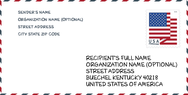
Envelop Voorbeeld

Dit is een voorbeeld van een Amerikaanse postenvelop. U kunt een 5-cijferige postcode of een gedetailleerde 9-cijferige postcode gebruiken om de mail in het volgende adresformaat te kopiëren.
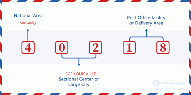
40218 Basisbetekenis
Waar staat elk cijfer van postcode 40218 voor? Het eerste cijfer geeft een nationaal gebied aan, dat varieert van nul voor het noordoosten tot negen voor het verre westen. De 2-3 cijfers zijn de code van een sectiecentrumfaciliteit in die regio. De laatste twee cijfers duiden kleine postkantoren of postzones aan.
Online landkaart

Het is een online kaart van adres West Buechel, Kentucky, United States. U kunt Knopje gebruiken te in/uitzoomen. De kaartinformatie is alleen ter referentie.
Universiteit

This is the ZIP Code 40218 - University page list. Its detail university Name, Street, City, State, ZIP Code, Phone is as below.
| Naam | Straat | Stad | Staat | Postcode | Telefoon |
| Sullivan College of Technology and Design | 3901 Atkinson Square Dr | Louisville | KY | 40218 | - |
Bibliotheek

Dit is de paginalijst van Postcode 40218 - Bibliotheek. Hieronder is het detail van Bibliotheek Naam, Adres, Stad, Staat, Postcode, Telefoon.
- Naam: NEWBURG BRANCH
- Adres: 4800 EXETER AVENUE
- Stad: LOUISVILLE
- Staat: KY - Kentucky
- Postcode: 40218
- Telefoon: (502) 479-6160
School
Dit is de paginalijst van Postcode 40218 - School. Hieronder is het detail van School Naam, Adres, Stad, Staat, Postcode.
| School Naam | Adres | Stad | Staat | Klassen | Postcode |
|---|---|---|---|---|---|
| Newburg Middle | 4901 Exeter Avenue | Louisville | KY | UG | 40218 |
| Watterson Elementary | 3900 Breckinridge Lane | Louisville | KY | UG | 40218 |
| Price Elementary | 5001 Garden Green Way | Louisville | KY | UG | 40218 |
| Klondike Lane Elementary | 3807 Klondike Ln | Louisville | KY | UG | 40218 |
| Boys & Girls Haven | 2301 Goldsmith Ln | Louisville | KY | UG | 40218 |
| Newcomer Academy | 3741 Pulliam Dr | Louisville | KY | UG | 40218 |
| Home/Hospital | 3332 Newburg Road | Louisville | KY | UG | 40218 |
| Brooklawn | 3121 Brooklawn Campus Drive | Louisville | KY | UG | 40218 |
| Minor Daniels Academy | 1960 Bashford Manor Ln | Louisville | KY | UG | 40218 |
Population for Postcode 40218

What is the total population in ZIP Code 40218? Below is detail information.
- Population for Postcode 40218: 32,354
- 2010 Bevolking: 31,658
The 2020 demographic statistics are in progress. The current population in ZIP code 40218 is 32,354, and the population in 2010 is 31,658.
Geslacht

In all the statistical population, the male population is 15,058, the female population is 16,600.
- Male Population: 15,058
- Female Population: 16,600
Race

In all the statistical population, the male population is 15,058, the female population is 16,600.
- White Population: 17,179
- Black Population: 13,190
- Hispanic Population: 2,643
- Asian Population: 932
- Hawaiian Population: 61
- Indian Population: 273
- Other Population: 1,225
Leeftijd

In all the statistical population, the White population is 17,179, the Black population is 13,190, the Hispanic population is 2,643, the Asian population is 932, the Hawaiian population is 61, the Indian Ppopulation is 273 and Other population is 1,225.
- Age's Median: 34.8
- Median of male age: 32.8
- Median of female age: 36.9
Households for Postcode 40218
ZIP code 40218 has 13,533 households, with an average number of 2.30 persons per household. The average income per household in Zip code 40218 is 44,587 USD, and the average house value is 135,100 USD.
- Households Per Zipcode: 13,533
- Personen per huishouden: 2.30
- Gemiddelde huiswaarde: 135,100
- Inkomen per huishouden: 44,587
Geographic

The latitude of the Zip code 40218 is 38.191545, the longitude is -85.657321, and the elevation is 489. It has land area of 9.736 square miles, and water area of 0.051 square miles. The time zone for ZIP code 40218 is Eastern (GMT -05:00). Daylight saving time should be observed in the area where the zip code is located.
- Breedtegraad: 38.191545
- Lengte: -85.657321
- Elevatie: 489
- Landoppervlak: 9.736
- Water Area: 0.051
- Tijd Zone: Eastern (GMT -05:00)
- Regio: South
- Divisie: East South Central
- Zomertijd: Y
congresdistrict

The Congressional District for ZIP code 40218 is Kentucky's 3rd congressional district, the Congressional Land Area is 319.34 square mile.
- congresdistrict: 3rd
- Congresgebied: 319.34
Levering

In the ZIP code 40218, there are 14,067 residential delivery mailboxes and centralized units, and 1,273 commercial delivery mailbox and centralized units, 8,132 single family deliveries and 3,501 multifamily deliveries, and the box count is 15,353. The main post office has city delivery carrier routes for the ZIP code 40218.
- Delivery Residential: 14,067
- Delivery Business: 1,273
- Delivery Total: 15,353
- Leveringseenheden voor één gezin: 8,132
- Multi Family Delivery Units: 3,501
- Stadsleveringsindicator: Y
Bedrijf

In ZIP code 40218, the number of business is 905, the number of employee is 19,693, the business first quarter payroll is 211,605,000 USD, the business annual payroll is 891,842,000 USD.
- Number Of Businesses: 905
- Number Of Employees: 19,693
- Zakelijke salarisadministratie eerste kwartaal: 211,605,000
- Zakelijke jaarlijkse loonlijst: 891,842,000
Sociale zekerheid

Er zijn 5,560 begunstigden met uitkeringen in de huidige betalingsstatus voor postcode 40218, waarvan 3,575 gepensioneerde werknemers, 1,120 gehandicapte werknemers, 310 weduwnaar (eren) en ouders, 110 zijn echtgenoten en 445 zijn kinderen. Het aantal begunstigden van 65 jaar of ouder is 3,705. De totale maandelijkse uitkeringen bedragen 6,974,000 USD, waarvan 4,975,000 USD voor gepensioneerde werknemers, 390,000 USD voor weduwnaar (eren) en ouders.
- Totaal aantal: 5,560
- Aantal gepensioneerden: 3,575
- Aantal gehandicapte werknemers: 1,120
- Weduwe / weduwnaar (er) en ouders Aantal: 310
- Echtgenoten nummer: 110
- Aantal kinderen: 445
- Alle begunstigden per maand: 6,974,000
- Gepensioneerde werknemers per maand: 4,975,000
- Weduwe (n) en ouders per maand: 390,000
- Aantal begunstigden van 65 jaar of ouder: 3,705


Reactie toevoegen