United States ZIP Code: 00669
This is the Puerto Rico ZIP Code 00669 page list. Its detail State, County, City, Longitude, Latitude, Envelope Example, Population is as below.

ZIP Code 00669 Information

-
-
Country:
U.S. - United States
State:
State FIPS:
72
Area Code:
ZIP Code:
00669
ZIP Type:
S (Standard)
❓What does S (Standard) mean? A "standard" ZIP Code is what most people think of when they talk about ZIP Codes - essentially a town, city, or a division of a city that has mail service.
ZIP Code 00669 - City

This is the city information corresponding to 00669:
| State | County | City | City Type ?In many cases, a ZIP Code can have multiple "names", meaning cities, towns, or subdivisions, in its boundaries. However, it will ALWAYS have exactly 1 "default" name. D - Default - This is the "preferred" name - by the USPS - for a city. Each ZIP Code has one - and only one - "default" name. In most cases, this is what people who live in that area call the city as well. A - Acceptable - This name can be used for mailing purposes. Often times alternative names are large neighborhoods or sections of the city/town. In some cases a ZIP Code may have several "acceptable" names which is used to group towns under one ZIP Code. N - Not Acceptable - A "not acceptable" name is, in many cases, a nickname that residents give that location. According to the USPS, you should NOT send mail to that ZIP Code using the "not acceptable" name when mailing. | ZIP Code |
|---|---|---|---|---|
| PR | Lares | Haciendas De Borinquen Ii | N (Not Acceptable) | 00669 |
| PR | Lares | Lares | D (Default) | 00669 |
| PR | Lares | Urb Buena Vista | N (Not Acceptable) | 00669 |
❓What does D (Default) mean? This is the "preferred" name - by the USPS - for a city. Each ZIP Code has one - and only one - "default" name. In most cases, this is what people who live in that area call the city as well.
❓What does N (Not Acceptable) mean? A "not acceptable" name is, in many cases, a nickname that residents give that location. According to the USPS, you should NOT send mail to that ZIP Code using the "not acceptable" name when mailing.
ZIP Code 00669 Plus 4
ZIP Code 5 plus 4 is the extension of 5-digit zip code, It can be used to locate a more detailed location. The last four digits designate segment or one side of a street or an apartment. You can find the ZIP+4 code and corresponding address of the zip code 00669 below.
| ZIP Code 5 Plus 4 | Address |
|---|---|
| 00669-0001 | PO BOX 1, LARES, PR |
| 00669-0121 | PO BOX 121, LARES, PR |
| 00669-0201 | PO BOX 202, LARES, PR |
| 00669-0203 | PO BOX 203, LARES, PR |
| 00669-0241 | PO BOX 241, LARES, PR |
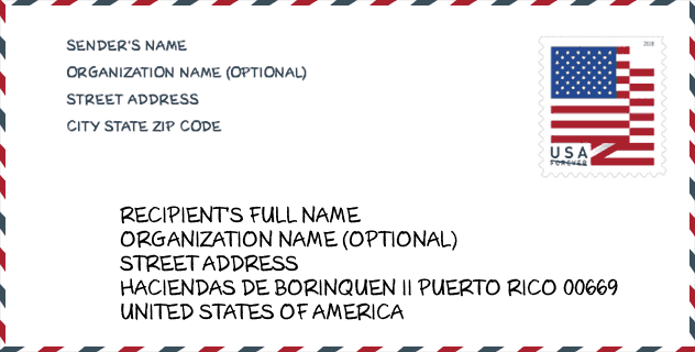
Envelope Example

This is an example of a US zip envelope. You can use a 5-digit zipcode or a detailed 9-digit zipcode to copy the mail in the following address format.
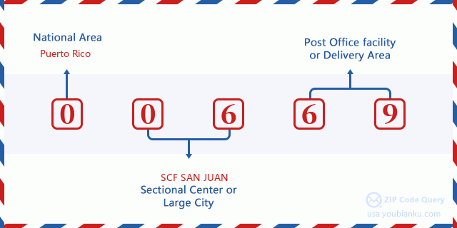
00669 Basic Meaning
What does each digit of ZIP Code 00669 stands for? The first digit designates a national area, which ranges from zero for the Northeast to nine for the far West. The 2-3 digits are the code of a sectional center facility in that region. The last two digits designate small post offices or postal zones.
Online Map

This is online map of the address Urb Buena Vista, Puerto Rico, United States. You may use button to move and zoom in / out. The map information is for reference only.
School

This is the ZIP Code 00669 - School page list. Its detail School Name, Address, City, State, ZIP Code is as below.
| School Name | Address | City | State | Grades | ZIP Code |
|---|---|---|---|---|---|
| ELEMENTAL DANIEL VELEZ SOTO | CARR 111 KM 2 HM 0 | LARES | PR | UG | 00669 |
| DOMINGO APONTE COLLAZO | CARR 111 CALLE RAMON DE JESUS SIERRA | LARES | PR | UG | 00669 |
| GEORGE WASHINGTON | CARR 111 KM 33 HM 9 BO PUEBLO SECT BURUQUILLO | LARES | PR | UG | 00669 |
| JULIO LEBRON SOTO | CARR 135 KM 60 BO CASTANER | LARES | PR | UG | 00669 |
| PROFESOR RAFAEL ALICEA VAZQUEZ (JOSEFINA LINARES) | CARR 111 KM 12.5 BO. LARES | LARES | PR | UG | 00669 |
| SU ANGELICA DELGADO (SU AMERICA) | CARR 129 KM 135 BARRIO BUENOS AIRES SEC LA AMERICA | LARES | PR | UG | 00669 |
| GABRIELA MISTRAL | CARR 135 KM 65.6 | LARES | PR | UG | 00669 |
| HECTOR HERNANDEZ ARANA (INTERMEDIA BO PILETAS) | CARR 129 KM 24.7 | LARES | PR | UG | 00669 |
| RAMON DE JESUS SIERRA | AVE LOS PATRIOTAS | LARES | PR | UG | 00669 |
Population for ZIP Code 00669

What is the total population in ZIP Code 00669? Below is detail information.
- Population for ZIP Code 00669: 15,397
- 2010 Population: 29,744
The 2020 demographic statistics are in progress. The current population in ZIP code 00669 is 15,397, and the population in 2010 is 29,744.
Gender

In all the statistical population, the male population is 14,621, the female population is 15,123.
- Male Population: 14,621
- Female Population: 15,123
Race

In all the statistical population, the male population is 14,621, the female population is 15,123.
- White Population: 27,619
- Black Population: 1,297
- Hispanic Population: 29,536
- Asian Population: 33
- Hawaiian Population: 22
- Indian Population: 156
- Other Population: 1,305
Age

In all the statistical population, the White population is 27,619, the Black population is 1,297, the Hispanic population is 29,536, the Asian population is 33, the Hawaiian population is 22, the Indian Ppopulation is 156 and Other population is 1,305.
- Age's Median: 37.0
- Median of male age: 35.8
- Median of female age: 38.3
Households for ZIP Code 00669
ZIP code 00669 has 10,740 households, with an average number of 2.75 persons per household. The average income per household in Zip code 00669 is 14,816 USD, and the average house value is 88,000 USD.
- Households Per Zipcode: 10,740
- Persons Per Household: 2.75
- Average House Value: 88,000
- Income Per Household: 14,816
Geographic

The latitude of the Zip code 00669 is 18.291418, the longitude is -66.867756, and the elevation is 1029. It has land area of 61.552 square miles, and water area of 0.065 square miles. The time zone for ZIP code 00669 is Atlantic (GMT -04:00). Daylight saving time should be observed in the area where the zip code is located.
- Latitude: 18.291418
- Longitude: -66.867756
- Elevation: 1029
- Land Area: 61.552
- Water Area: 0.065
- Time Zone: Atlantic (GMT -04:00)
- Day Light Saving: N
Delivery

In the ZIP code 00669, there are 5,599 residential delivery mailboxes and centralized units, and 190 commercial delivery mailbox and centralized units, 3,566 single family deliveries and 272 multifamily deliveries, and the box count is 7,421. The main post office has city delivery carrier routes for the ZIP code 00669.
- Delivery Residential: 5,599
- Delivery Business: 190
- Delivery Total: 7,421
- Single Family Delivery Units: 3,566
- Multi Family Delivery Units: 272
- City Delivery Indicator: Y


Add new comment