United States ZIP Code: 00676
This is the Puerto Rico ZIP Code 00676 page list. Its detail State, County, City, Longitude, Latitude, Envelope Example, Population is as below.

ZIP Code 00676 Information

-
-
Country:
U.S. - United States
State:
State FIPS:
72
ZIP Code:
00676
ZIP Type:
S (Standard)
❓What does S (Standard) mean? A "standard" ZIP Code is what most people think of when they talk about ZIP Codes - essentially a town, city, or a division of a city that has mail service.
-


-
Iconic US Landmark Legacy Designs
Get PNG, SVG, EPS, AI, PDF Versions at Just $0.1
 Download Now
-


ZipCodeCraft
ZIP Code 00676 - City

This is the city information corresponding to 00676:
| State | County | City | City Type ?In many cases, a ZIP Code can have multiple "names", meaning cities, towns, or subdivisions, in its boundaries. However, it will ALWAYS have exactly 1 "default" name. D - Default - This is the "preferred" name - by the USPS - for a city. Each ZIP Code has one - and only one - "default" name. In most cases, this is what people who live in that area call the city as well. A - Acceptable - This name can be used for mailing purposes. Often times alternative names are large neighborhoods or sections of the city/town. In some cases a ZIP Code may have several "acceptable" names which is used to group towns under one ZIP Code. N - Not Acceptable - A "not acceptable" name is, in many cases, a nickname that residents give that location. According to the USPS, you should NOT send mail to that ZIP Code using the "not acceptable" name when mailing. | ZIP Code |
|---|---|---|---|---|
| PR | Moca | Hacienda La Monserrate | N (Not Acceptable) | 00676 |
| PR | Moca | Moca | D (Default) | 00676 |
| PR | Moca | Parc Lomas Verdes | N (Not Acceptable) | 00676 |
| PR | Moca | Parc Sabana | N (Not Acceptable) | 00676 |
| PR | Moca | Res Edad Dorada | N (Not Acceptable) | 00676 |
| PR | Moca | Urb Las Palmas | N (Not Acceptable) | 00676 |
| PR | Moca | Urb Los Robles | N (Not Acceptable) | 00676 |
| PR | Moca | Urb Moca Gdns | N (Not Acceptable) | 00676 |
| PR | Moca | Urb Monte Verde Hills | N (Not Acceptable) | 00676 |
| PR | Moca | Villa Deloamit | N (Not Acceptable) | 00676 |
| PR | Moca | Villa Mercedes | N (Not Acceptable) | 00676 |
| PR | Moca | Villa Soto | N (Not Acceptable) | 00676 |
❓What does D (Default) mean? This is the "preferred" name - by the USPS - for a city. Each ZIP Code has one - and only one - "default" name. In most cases, this is what people who live in that area call the city as well.
❓What does N (Not Acceptable) mean? A "not acceptable" name is, in many cases, a nickname that residents give that location. According to the USPS, you should NOT send mail to that ZIP Code using the "not acceptable" name when mailing.
ZIP Code 00676 Plus 4
ZIP Code 5 plus 4 is the extension of 5-digit zip code, It can be used to locate a more detailed location. The last four digits designate segment or one side of a street or an apartment. You can find the ZIP+4 code and corresponding address of the zip code 00676 below.
| ZIP Code 5 Plus 4 | Address |
|---|---|
| 00676-0001 | PO BOX 1, MOCA, PR |
| 00676-0121 | PO BOX 121, MOCA, PR |
| 00676-0241 | PO BOX 241, MOCA, PR |
| 00676-0361 | PO BOX 361, MOCA, PR |
| 00676-0481 | PO BOX 481, MOCA, PR |
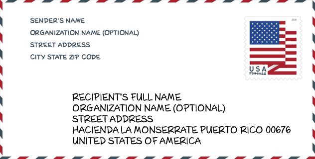
Envelope Example

This is an example of a US zip envelope. You can use a 5-digit zipcode or a detailed 9-digit zipcode to copy the mail in the following address format.
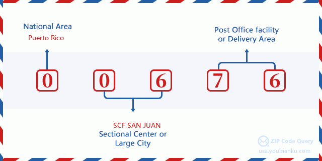
00676 Basic Meaning
What does each digit of ZIP Code 00676 stands for? The first digit designates a national area, which ranges from zero for the Northeast to nine for the far West. The 2-3 digits are the code of a sectional center facility in that region. The last two digits designate small post offices or postal zones.
Online Map

This is online map of the address Villa Soto, Puerto Rico, United States. You may use button to move and zoom in / out. The map information is for reference only.
University

This is the ZIP Code 00676 - University page list. Its detail university Name, Street, City, State, ZIP Code, Phone is as below.
| Name | Street | City | State | ZIP Code | Phone |
| Institute of Beauty Occupation and Technology Course | 500 Calle Concepcion Vera | Moca | PR | 00676 | - |
Hospital

This is the ZIP Code 00676 - Hospital page list. Its detail Hospital Name, Street, City, State, ZIP Code, Phone is as below.
- Name: HOSPITAL SAN CARLOS BORROMEO
- Address: MOCA
- City: CALLE CONCEPCION VERA AYALA #550 S
- State: PR
- ZIP Code: 00676
- Phone: (787) 877-8000
School
This is the ZIP Code 00676 - School page list. Its detail School Name, Address, City, State, ZIP Code is as below.
| School Name | Address | City | State | Grades | ZIP Code |
|---|---|---|---|---|---|
| SUPERIOR CATALINA MORALES FLORES | CARR 110 CALLE CONCEPCION VERA | MOCA | PR | UG | 00676 |
| TOMAS VERA AYALA | CARR 111 KM 4 HM 0 BO PLATA ALTA | MOCA | PR | UG | 00676 |
| CERRO GORDO MEDINA | CARR 420 INT 495 KM 2.0 | MOCA | PR | UG | 00676 |
| CUCHILLAS | CARR 444 KM 3 HM 7 | MOCA | PR | UG | 00676 |
| JUAN DE DIOS QUINONES | CARR 125 KM 9 HM 7 BO VOLADORA | MOCA | PR | UG | 00676 |
| DR EFRAIN SANCHEZ HIDALGO | CALLE MONSENOR JOSE TORRES | MOCA | PR | UG | 00676 |
| MARCELINO RODRIGUEZ ROMAN | CARR 125 KM 0 HM 2 BO VOLADORA | MOCA | PR | UG | 00676 |
| LUIS COLON (ADOLFO BABILONIA) | 230 CALLE ISABELA PUEBLO | MOCA | PR | UG | 00676 |
Population for ZIP Code 00676

What is the total population in ZIP Code 00676? Below is detail information.
- Population for ZIP Code 00676: 18,992
- 2010 Population: 40,316
The 2020 demographic statistics are in progress. The current population in ZIP code 00676 is 18,992, and the population in 2010 is 40,316.
Gender

In all the statistical population, the male population is 19,778, the female population is 20,538.
- Male Population: 19,778
- Female Population: 20,538
Race

In all the statistical population, the male population is 19,778, the female population is 20,538.
- White Population: 36,842
- Black Population: 2,397
- Hispanic Population: 40,090
- Asian Population: 47
- Hawaiian Population: 14
- Indian Population: 143
- Other Population: 1,793
Age

In all the statistical population, the White population is 36,842, the Black population is 2,397, the Hispanic population is 40,090, the Asian population is 47, the Hawaiian population is 14, the Indian Ppopulation is 143 and Other population is 1,793.
- Age's Median: 35.1
- Median of male age: 34.3
- Median of female age: 35.8
Households for ZIP Code 00676
ZIP code 00676 has 14,431 households, with an average number of 2.78 persons per household. The average income per household in Zip code 00676 is 14,146 USD, and the average house value is 96,500 USD.
- Households Per Zipcode: 14,431
- Persons Per Household: 2.78
- Average House Value: 96,500
- Income Per Household: 14,146
Geographic

The latitude of the Zip code 00676 is 18.385559, the longitude is -67.082204, and the elevation is 186. It has land area of 50.437 square miles, and water area of 0.022 square miles. The time zone for ZIP code 00676 is Atlantic (GMT -04:00). Daylight saving time should be observed in the area where the zip code is located.
- Latitude: 18.385559
- Longitude: -67.082204
- Elevation: 186
- Land Area: 50.437
- Water Area: 0.022
- Time Zone: Atlantic (GMT -04:00)
- Day Light Saving: N
Delivery

In the ZIP code 00676, there are 6,832 residential delivery mailboxes and centralized units, and 271 commercial delivery mailbox and centralized units, 3,128 single family deliveries and 1,750 multifamily deliveries, and the box count is 11,998. The main post office has city delivery carrier routes for the ZIP code 00676.
- Delivery Residential: 6,832
- Delivery Business: 271
- Delivery Total: 11,998
- Single Family Delivery Units: 3,128
- Multi Family Delivery Units: 1,750
- City Delivery Indicator: Y


Add new comment