邮政编码: 72955, Uniontown, AR
邮政编码72955位于 Uniontown, Arkansas。其详细的的信息:州、县、市、经度、纬度、信封示例、人口如下。

邮政编码72955信息

-
-
国家:
U.S. - 美国
县FIPS:
05033
城市:
区号:
城市类型 ?In many cases, a ZIP Code can have multiple "names", meaning cities, towns, or subdivisions, in its boundaries. However, it will ALWAYS have exactly 1 "default" name. D - Default - This is the "preferred" name - by the USPS - for a city. Each ZIP Code has one - and only one - "default" name. In most cases, this is what people who live in that area call the city as well. A - Acceptable - This name can be used for mailing purposes. Often times alternative names are large neighborhoods or sections of the city/town. In some cases a ZIP Code may have several "acceptable" names which is used to group towns under one ZIP Code. N - Not Acceptable - A "not acceptable" name is, in many cases, a nickname that residents give that location. According to the USPS, you should NOT send mail to that ZIP Code using the "not acceptable" name when mailing.:
D (Default)
邮政编码:
72955
❓D (Default)是什么意思?这是USPS的“首选”城市名称。每个邮政编码都有且仅有一个 “默认”名称。在大多数情况下,这也是当地居民所说的城市。
邮政编码72955加4
ZIP Code 5+4 是5位邮政编码的扩展,可以用来定位更详细的位置。最后四位数字表示路段或街道的一侧或公寓。您可以在下面找到邮政编码 72955 的 ZIP+4 代码和对应地址。
| 邮政编码5加4 | 地址 |
|---|---|
| 72955-0201 | PO BOX 201, UNIONTOWN, AR |
| 72955-0301 | PO BOX 301, UNIONTOWN, AR |
| 72955-0401 | PO BOX 401, UNIONTOWN, AR |
| 72955-0501 | PO BOX 501, UNIONTOWN, AR |
| 72955-9000 | 10000 UNIONTOWN HWY, UNIONTOWN, AR |
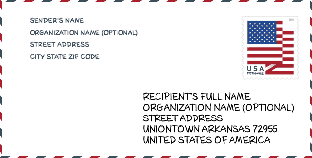
信封例子

这是一个美国邮政信封的示例。当您需要邮寄时,您可以使用5位邮政编码或详细的9位邮政编码来复制示例地址。
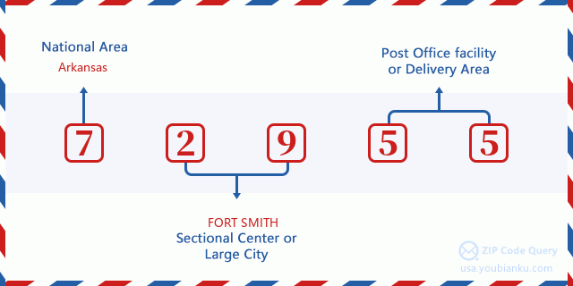
72955基本含义
邮政编码72955的每个数字代表什么?第一个数字表示国家区域,范围从东北部的零到远西部的九。 2-3位数字是该地区的分区中心设施的代码。最后两位数字表示小型邮局或邮政区。
在线地图

这是地址Uniontown, Arkansas, United States匹配的在线电子地图。您可以使用图中按钮来移动、缩放。该地图信息仅供参考。
邮政编码72955人口

邮政编码72955的总人口是多少?以下是详细信息。
- 邮政编码72955人口: 400
- 2010 人口: 438
2020年的人口统计数据正在进行中。 邮政编码72955中的当前人口为400,2010年的人口为438。
性别

在所有统计人口中,男性人口为234,女性人口为204。
- 男性人口: 234
- 女性人口: 204
种族

在所有统计人口中,男性人口为234,女性人口为204。
- 白人人口: 415
- 黑人人口: 0
- 西班牙裔人口: 9
- 亚洲人口: 1
- 夏威夷人口: 0
- 印度裔人口: 38
- 其他人口: 3
年龄

在所有统计人口中,白人人口为415,黑人人口为0,西班牙裔人口为9,亚裔人口为1,夏威夷裔人口为0,印度裔人口为38,其他人口为3。
- 年龄的中位数: 42.2
- 男性年龄中位数: 42.5
- 女性年龄中位数: 41.5
邮政编码72955的家庭
邮政编码72955有154户,平均每户2.84人。 邮政编码72955中的每户平均收入为46,607美元,平均房屋价值为102,000美元。
- 每个邮政编码的住户: 154
- 每户人数: 2.84
- 平均房屋价值: 102,000
- 每户收入: 46,607
地域信息

邮政编码72955的纬度为35.601215,经度为-94.437741,海拔为1019。其土地面积为12.434平方英里,水域为0平方英里。邮政编码72955的时区为Central (GMT -06:00)。邮政编码所在的区域应遵守夏令时。
- 纬度: 35.601215
- 经度: -94.437741
- 海拔: 1019
- 土地面积: 12.434
- 水域面积: 0
- 时区: Central (GMT -06:00)
- 区域: South
- 区: West South Central
- 夏令时: Y
国会区

邮政编码72955的国会区是Arkansas的3rd国会区,国会土地面积是5400.99平方英里。
- 国会区: 3rd
- 国会土地面积: 5400.99
邮递信息

在邮政编码72955中,有141个住宅邮箱和集中式单位,以及0个商业邮箱和集中式单位,有141个单户邮箱和0个多户邮箱,邮箱总数为243。总邮局没有邮政编码为72955的城市快递公司路线。
- 住宅邮箱: 141
- 商业邮箱: 0
- 邮箱总额: 243
- 单户邮箱: 141
- 多户邮箱: 0
- 城市配送路线: N
社会保障福利

邮政编码72955的当前受益人数为160,其中退休人员人数为90,残疾人数为40,寡居人数为5,配偶人数为5,孩子人数为20。 65岁或以上的受益人数为95。每月总受益金额为188,000美元,其中退休工人为121,000美元,寡居为8,000美元。
- 总数: 160
- 离退休职工人数: 90
- 残疾人人数: 40
- 寡居人数: 5
- 配偶人数: 5
- 儿童人数: 20
- 每月所有受益金额: 188,000
- 退休工人每月领取受益金金额: 121,000
- 寡居人士每月领取受益金金额: 8,000
- 65岁或以上的受益人人数: 95


添加新评论