United States ZIP Code: 00682
This is the Puerto Rico ZIP Code 00682 page list. Its detail State, County, City, Longitude, Latitude, Envelope Example, Population is as below.

ZIP Code 00682 Information

-
-
Country:
U.S. - United States
State:
State FIPS:
72
ZIP Code:
00682
ZIP Type:
S (Standard)
❓What does S (Standard) mean? A "standard" ZIP Code is what most people think of when they talk about ZIP Codes - essentially a town, city, or a division of a city that has mail service.
ZIP Code 00682 - City

This is the city information corresponding to 00682:
| State | County | City | City Type ?In many cases, a ZIP Code can have multiple "names", meaning cities, towns, or subdivisions, in its boundaries. However, it will ALWAYS have exactly 1 "default" name. D - Default - This is the "preferred" name - by the USPS - for a city. Each ZIP Code has one - and only one - "default" name. In most cases, this is what people who live in that area call the city as well. A - Acceptable - This name can be used for mailing purposes. Often times alternative names are large neighborhoods or sections of the city/town. In some cases a ZIP Code may have several "acceptable" names which is used to group towns under one ZIP Code. N - Not Acceptable - A "not acceptable" name is, in many cases, a nickname that residents give that location. According to the USPS, you should NOT send mail to that ZIP Code using the "not acceptable" name when mailing. | ZIP Code |
|---|---|---|---|---|
| PR | Mayaguez | Alt De Algarrobo | N (Not Acceptable) | 00682 |
| PR | Mayaguez | Alt De Mayaguez | N (Not Acceptable) | 00682 |
| PR | Mayaguez | Bo Dulces Labios | N (Not Acceptable) | 00682 |
| PR | Mayaguez | Bo El Seco | N (Not Acceptable) | 00682 |
| PR | Mayaguez | Bo Mani | N (Not Acceptable) | 00682 |
| PR | Mayaguez | Bo Tras Talleres | N (Not Acceptable) | 00682 |
| PR | Mayaguez | Jard De Guanajibo | N (Not Acceptable) | 00682 |
| PR | Mayaguez | Jard Del Caribe | N (Not Acceptable) | 00682 |
| PR | Mayaguez | Mans De Espana | N (Not Acceptable) | 00682 |
| PR | Mayaguez | Mayaguez | D (Default) | 00682 |
| PR | Mayaguez | Parc Castillo | N (Not Acceptable) | 00682 |
| PR | Mayaguez | Parc Mani | N (Not Acceptable) | 00682 |
| PR | Mayaguez | Parc Soledad | N (Not Acceptable) | 00682 |
| PR | Mayaguez | Parq De La Ceiba | N (Not Acceptable) | 00682 |
| PR | Mayaguez | Repto Los Chevres | N (Not Acceptable) | 00682 |
| PR | Mayaguez | Repto San Francisco | N (Not Acceptable) | 00682 |
| PR | Mayaguez | Urb Bella Lomas | N (Not Acceptable) | 00682 |
| PR | Mayaguez | Urb Buenaventura | N (Not Acceptable) | 00682 |
| PR | Mayaguez | Urb Ensanche Ramirez | N (Not Acceptable) | 00682 |
| PR | Mayaguez | Urb Fraternidad | N (Not Acceptable) | 00682 |
| PR | Mayaguez | Urb Guanajibo Gdns | N (Not Acceptable) | 00682 |
| PR | Mayaguez | Urb Guanajibo Homes | N (Not Acceptable) | 00682 |
| PR | Mayaguez | Urb Hostos | N (Not Acceptable) | 00682 |
| PR | Mayaguez | Urb La Riviera | N (Not Acceptable) | 00682 |
| PR | Mayaguez | Urb Llavat | N (Not Acceptable) | 00682 |
| PR | Mayaguez | Urb Los Versalles | N (Not Acceptable) | 00682 |
| PR | Mayaguez | Urb Mayaguez Terrace | N (Not Acceptable) | 00682 |
| PR | Mayaguez | Urb Mendoza | N (Not Acceptable) | 00682 |
| PR | Mayaguez | Urb Miradero Gdns | N (Not Acceptable) | 00682 |
| PR | Mayaguez | Urb Miradero Hls | N (Not Acceptable) | 00682 |
| PR | Mayaguez | Urb Petiteville | N (Not Acceptable) | 00682 |
| PR | Mayaguez | Urb Quinto Centenario | N (Not Acceptable) | 00682 |
| PR | Mayaguez | Urb Ramirez De Arellano | N (Not Acceptable) | 00682 |
| PR | Mayaguez | Urb San Jose | N (Not Acceptable) | 00682 |
| PR | Mayaguez | Urb Santa Rosa De Lima | N (Not Acceptable) | 00682 |
| PR | Mayaguez | Urb Westernlake Vlg | N (Not Acceptable) | 00682 |
| PR | Mayaguez | Villas Del Oeste | N (Not Acceptable) | 00682 |
| PR | Mayaguez | Vista Verde | N (Not Acceptable) | 00682 |
❓What does D (Default) mean? This is the "preferred" name - by the USPS - for a city. Each ZIP Code has one - and only one - "default" name. In most cases, this is what people who live in that area call the city as well.
❓What does N (Not Acceptable) mean? A "not acceptable" name is, in many cases, a nickname that residents give that location. According to the USPS, you should NOT send mail to that ZIP Code using the "not acceptable" name when mailing.
ZIP Code 00682 Plus 4
ZIP Code 5 plus 4 is the extension of 5-digit zip code, It can be used to locate a more detailed location. The last four digits designate segment or one side of a street or an apartment. You can find the ZIP+4 code and corresponding address of the zip code 00682 below.
| ZIP Code 5 Plus 4 | Address |
|---|---|
| 00682-1100 | 600 CALLE R RAMIREZ PABON, MAYAGUEZ, PR |
| 00682-1101 | 525 AVE GONZALEZ CLEMENTE #217L , MAYAGUEZ, PR |
| 00682-1102 | 150 CALLE JOSE P MORALES, MAYAGUEZ, PR |
| 00682-1103 | 525 AVE GONZALEZ CLEMENTE #210R , MAYAGUEZ, PR |
| 00682-1104 | 525 AVE GONZALEZ CLEMENTE #204L , MAYAGUEZ, PR |
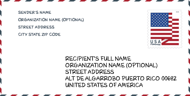
Envelope Example

This is an example of a US zip envelope. You can use a 5-digit zipcode or a detailed 9-digit zipcode to copy the mail in the following address format.
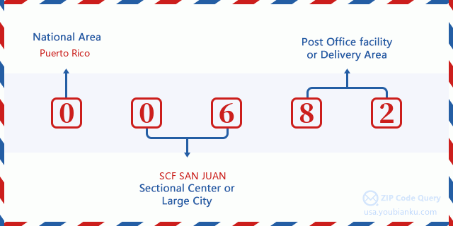
00682 Basic Meaning
What does each digit of ZIP Code 00682 stands for? The first digit designates a national area, which ranges from zero for the Northeast to nine for the far West. The 2-3 digits are the code of a sectional center facility in that region. The last two digits designate small post offices or postal zones.
Online Map

This is online map of the address Vista Verde, Puerto Rico, United States. You may use button to move and zoom in / out. The map information is for reference only.
Hospital

This is the ZIP Code 00682 - Hospital page list. Its detail Hospital Name, Street, City, State, ZIP Code, Phone is as below.
- Name: MAYAGUEZ MEDICAL CENTER
- Address: MAYAGUEZ
- City: CARR 2 BO SABALOS
- State: PR
- ZIP Code: 00682
- Phone: (787) 652-9200
School

This is the ZIP Code 00682 - School page list. Its detail School Name, Address, City, State, ZIP Code is as below.
| School Name | Address | City | State | Grades | ZIP Code |
|---|---|---|---|---|---|
| ESTEBAN ROSADO BAEZ | CARR. 341 BO. MANI | MAYAGUEZ | PR | UG | 00682 |
| ELVIRA RUPERTO QUILES (RIO CANAS ABAJO) | CARR 351 INT 352 BO RIO CANAS | MAYAGUEZ | PR | UG | 00682 |
| MARIA LUISA ARCELAY | CALLE SAN EXPEDITO RES. SABALOS NUEVO | MAYAGUEZ | PR | UG | 00682 |
| CENTRO RESIDENCIAL DE OPORTUNIDADES EDUCATIVAS DE MAYAGUEZ | CERRO LAS MESAS KM6 HM.9 | MAYAGUEZ | PR | UG | 00682 |
| ELPIDIO H. RIVERA | URB. RIO CRISTAL CALLE ROBERTO COLE 510 | MAYAGUEZ | PR | UG | 00682 |
Population for ZIP Code 00682

What is the total population in ZIP Code 00682? Below is detail information.
- Population for ZIP Code 00682: 29,991
- 2010 Population: 32,615
The 2020 demographic statistics are in progress. The current population in ZIP code 00682 is 29,991, and the population in 2010 is 32,615.
Gender

In all the statistical population, the male population is 15,586, the female population is 17,029.
- Male Population: 15,586
- Female Population: 17,029
Race

In all the statistical population, the male population is 15,586, the female population is 17,029.
- White Population: 26,346
- Black Population: 3,349
- Hispanic Population: 32,224
- Asian Population: 140
- Hawaiian Population: 13
- Indian Population: 355
- Other Population: 3,484
Age

In all the statistical population, the White population is 26,346, the Black population is 3,349, the Hispanic population is 32,224, the Asian population is 140, the Hawaiian population is 13, the Indian Ppopulation is 355 and Other population is 3,484.
- Age's Median: 36.1
- Median of male age: 32.6
- Median of female age: 39.7
Households for ZIP Code 00682
ZIP code 00682 has 12,899 households, with an average number of 2.51 persons per household. The average income per household in Zip code 00682 is 15,029 USD, and the average house value is 113,400 USD.
- Households Per Zipcode: 12,899
- Persons Per Household: 2.51
- Average House Value: 113,400
- Income Per Household: 15,029
Geographic

The latitude of the Zip code 00682 is 18.220812, the longitude is -67.147741, and the elevation is 44. It has land area of 14.403 square miles, and water area of 2.441 square miles. The time zone for ZIP code 00682 is Atlantic (GMT -04:00). Daylight saving time should be observed in the area where the zip code is located.
- Latitude: 18.220812
- Longitude: -67.147741
- Elevation: 44
- Land Area: 14.403
- Water Area: 2.441
- Time Zone: Atlantic (GMT -04:00)
- Day Light Saving: N
Delivery

In the ZIP code 00682, there are 11,949 residential delivery mailboxes and centralized units, and 847 commercial delivery mailbox and centralized units, 7,680 single family deliveries and 3,489 multifamily deliveries, and the box count is 12,772. The main post office has city delivery carrier routes for the ZIP code 00682.
- Delivery Residential: 11,949
- Delivery Business: 847
- Delivery Total: 12,772
- Single Family Delivery Units: 7,680
- Multi Family Delivery Units: 3,489
- City Delivery Indicator: Y


Add new comment