United States ZIP Code: 00772
This is the Puerto Rico ZIP Code 00772 page list. Its detail State, County, City, Longitude, Latitude, Envelope Example, Population is as below.

ZIP Code 00772 Information

-
-
Country:
U.S. - United States
State:
State FIPS:
72
Area Code:
ZIP Code:
00772
ZIP Type:
S (Standard)
❓What does S (Standard) mean? A "standard" ZIP Code is what most people think of when they talk about ZIP Codes - essentially a town, city, or a division of a city that has mail service.
ZIP Code 00772 - City

This is the city information corresponding to 00772:
| State | County | City | City Type ?In many cases, a ZIP Code can have multiple "names", meaning cities, towns, or subdivisions, in its boundaries. However, it will ALWAYS have exactly 1 "default" name. D - Default - This is the "preferred" name - by the USPS - for a city. Each ZIP Code has one - and only one - "default" name. In most cases, this is what people who live in that area call the city as well. A - Acceptable - This name can be used for mailing purposes. Often times alternative names are large neighborhoods or sections of the city/town. In some cases a ZIP Code may have several "acceptable" names which is used to group towns under one ZIP Code. N - Not Acceptable - A "not acceptable" name is, in many cases, a nickname that residents give that location. According to the USPS, you should NOT send mail to that ZIP Code using the "not acceptable" name when mailing. | ZIP Code |
|---|---|---|---|---|
| PR | Loiza | Jard De Loiza | N (Not Acceptable) | 00772 |
| PR | Loiza | Loiza | D (Default) | 00772 |
| PR | Loiza | Sect Villa Canona | N (Not Acceptable) | 00772 |
| PR | Loiza | Urb Santiago | N (Not Acceptable) | 00772 |
| PR | Loiza | Vistas Del Oceano | N (Not Acceptable) | 00772 |
❓What does D (Default) mean? This is the "preferred" name - by the USPS - for a city. Each ZIP Code has one - and only one - "default" name. In most cases, this is what people who live in that area call the city as well.
❓What does N (Not Acceptable) mean? A "not acceptable" name is, in many cases, a nickname that residents give that location. According to the USPS, you should NOT send mail to that ZIP Code using the "not acceptable" name when mailing.
ZIP Code 00772 Plus 4
ZIP Code 5 plus 4 is the extension of 5-digit zip code, It can be used to locate a more detailed location. The last four digits designate segment or one side of a street or an apartment. You can find the ZIP+4 code and corresponding address of the zip code 00772 below.
| ZIP Code 5 Plus 4 | Address |
|---|---|
| 00772-0001 | PO BOX 1, LOIZA, PR |
| 00772-0121 | PO BOX 121, LOIZA, PR |
| 00772-0241 | PO BOX 241, LOIZA, PR |
| 00772-0361 | PO BOX 361, LOIZA, PR |
| 00772-0421 | PO BOX 421, LOIZA, PR |
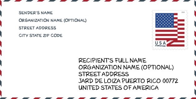
Envelope Example

This is an example of a US zip envelope. You can use a 5-digit zipcode or a detailed 9-digit zipcode to copy the mail in the following address format.
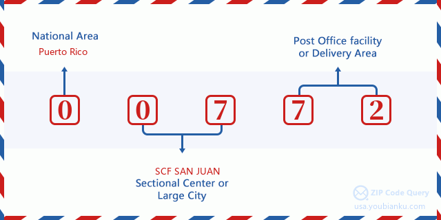
00772 Basic Meaning
What does each digit of ZIP Code 00772 stands for? The first digit designates a national area, which ranges from zero for the Northeast to nine for the far West. The 2-3 digits are the code of a sectional center facility in that region. The last two digits designate small post offices or postal zones.
Online Map

This is online map of the address Vistas Del Oceano, Puerto Rico, United States. You may use button to move and zoom in / out. The map information is for reference only.
School

This is the ZIP Code 00772 - School page list. Its detail School Name, Address, City, State, ZIP Code is as below.
| School Name | Address | City | State | Grades | ZIP Code |
|---|---|---|---|---|---|
| BELEN BLANCO DE ZEQUEIRA | URB SAN PATRICIO 205 CALLE CARLOS ESCOBAR | LOIZA | PR | UG | 00772 |
| JOBOS | CARR 187 KM 9 HM 8 BO MEDIANIA ALTA | LOIZA | PR | UG | 00772 |
| MEDIANIA ALTA ELEMENTAL | CARR 187 KM 5 HM 6 BO MEDIANIA ALTA | LOIZA | PR | UG | 00772 |
| SU NUEVA BO. MEDIANIA | CARR #187 KM 3 HM 9 BO MEDIANIA ALTA | LOIZA | PR | UG | 00772 |
| SUPERIOR VOC ELADIO RIVERA QUINONES (SUPERIOR VOC DE LOIZA) | CARR 187 KM 5 HM 6 BO MEDIANIA | LOIZA | PR | UG | 00772 |
| GUILLERMINA ROSADO DE AYALA | CALLE 25 URB VILLAS DE LOIZA | LOIZA | PR | UG | 00772 |
| ESCUELA PUBLICA BILINGUE CACICA YUISA - ALIANZA | PARCELAS VIEQUES #5 BO MEDIANIA ALTA | LOIZA | PR | UG | 00772 |
| CELSO GONZALEZ VAILLANT | CARR 188 KM 7 HM 2 | LOIZA | PR | UG | 00772 |
Population for ZIP Code 00772

What is the total population in ZIP Code 00772? Below is detail information.
- Population for ZIP Code 00772: 11,251
- 2010 Population: 23,105
The 2020 demographic statistics are in progress. The current population in ZIP code 00772 is 11,251, and the population in 2010 is 23,105.
Gender

In all the statistical population, the male population is 10,964, the female population is 12,141.
- Male Population: 10,964
- Female Population: 12,141
Race

In all the statistical population, the male population is 10,964, the female population is 12,141.
- White Population: 4,205
- Black Population: 17,743
- Hispanic Population: 22,989
- Asian Population: 44
- Hawaiian Population: 14
- Indian Population: 200
- Other Population: 1,505
Age

In all the statistical population, the White population is 4,205, the Black population is 17,743, the Hispanic population is 22,989, the Asian population is 44, the Hawaiian population is 14, the Indian Ppopulation is 200 and Other population is 1,505.
- Age's Median: 33.4
- Median of male age: 31.7
- Median of female age: 34.7
Households for ZIP Code 00772
ZIP code 00772 has 7,832 households, with an average number of 2.94 persons per household. The average income per household in Zip code 00772 is 15,658 USD, and the average house value is 94,900 USD.
- Households Per Zipcode: 7,832
- Persons Per Household: 2.94
- Average House Value: 94,900
- Income Per Household: 15,658
Geographic

The latitude of the Zip code 00772 is 18.419378, the longitude is -65.910867, and the elevation is 9. It has land area of 14.659 square miles, and water area of 5.267 square miles. The time zone for ZIP code 00772 is Atlantic (GMT -04:00). Daylight saving time should be observed in the area where the zip code is located.
- Latitude: 18.419378
- Longitude: -65.910867
- Elevation: 9
- Land Area: 14.659
- Water Area: 5.267
- Time Zone: Atlantic (GMT -04:00)
- Day Light Saving: N
Delivery

In the ZIP code 00772, there are 3,827 residential delivery mailboxes and centralized units, and 63 commercial delivery mailbox and centralized units, 652 single family deliveries and 2,657 multifamily deliveries, and the box count is 4,940. The main post office has city delivery carrier routes for the ZIP code 00772.
- Delivery Residential: 3,827
- Delivery Business: 63
- Delivery Total: 4,940
- Single Family Delivery Units: 652
- Multi Family Delivery Units: 2,657
- City Delivery Indicator: Y


Add new comment