United States ZIP Code: 00782
This is the Puerto Rico ZIP Code 00782 page list. Its detail State, County, City, Longitude, Latitude, Envelope Example, Population is as below.

ZIP Code 00782 Information

-
-
Country:
U.S. - United States
State:
State FIPS:
72
Area Code:
ZIP Code:
00782
ZIP Type:
S (Standard)
❓What does S (Standard) mean? A "standard" ZIP Code is what most people think of when they talk about ZIP Codes - essentially a town, city, or a division of a city that has mail service.
ZIP Code 00782 - City

This is the city information corresponding to 00782:
| State | County | City | City Type ?In many cases, a ZIP Code can have multiple "names", meaning cities, towns, or subdivisions, in its boundaries. However, it will ALWAYS have exactly 1 "default" name. D - Default - This is the "preferred" name - by the USPS - for a city. Each ZIP Code has one - and only one - "default" name. In most cases, this is what people who live in that area call the city as well. A - Acceptable - This name can be used for mailing purposes. Often times alternative names are large neighborhoods or sections of the city/town. In some cases a ZIP Code may have several "acceptable" names which is used to group towns under one ZIP Code. N - Not Acceptable - A "not acceptable" name is, in many cases, a nickname that residents give that location. According to the USPS, you should NOT send mail to that ZIP Code using the "not acceptable" name when mailing. | ZIP Code |
|---|---|---|---|---|
| PR | Comerio | Comerio | D (Default) | 00782 |
| PR | Comerio | Urb Ariel | N (Not Acceptable) | 00782 |
| PR | Comerio | Urb La Hacienda | N (Not Acceptable) | 00782 |
| PR | Comerio | Urb La Plata | N (Not Acceptable) | 00782 |
| PR | Comerio | Urb Pasarell | N (Not Acceptable) | 00782 |
| PR | Comerio | Urb Rio Plata | N (Not Acceptable) | 00782 |
| PR | Comerio | Urb Sabana Del Palmar | N (Not Acceptable) | 00782 |
❓What does D (Default) mean? This is the "preferred" name - by the USPS - for a city. Each ZIP Code has one - and only one - "default" name. In most cases, this is what people who live in that area call the city as well.
❓What does N (Not Acceptable) mean? A "not acceptable" name is, in many cases, a nickname that residents give that location. According to the USPS, you should NOT send mail to that ZIP Code using the "not acceptable" name when mailing.
ZIP Code 00782 Plus 4
ZIP Code 5 plus 4 is the extension of 5-digit zip code, It can be used to locate a more detailed location. The last four digits designate segment or one side of a street or an apartment. You can find the ZIP+4 code and corresponding address of the zip code 00782 below.
| ZIP Code 5 Plus 4 | Address |
|---|---|
| 00782-0001 | PO BOX 1, COMERIO, PR |
| 00782-0121 | PO BOX 121, COMERIO, PR |
| 00782-0241 | PO BOX 241, COMERIO, PR |
| 00782-0301 | PO BOX 301, COMERIO, PR |
| 00782-0421 | PO BOX 421, COMERIO, PR |
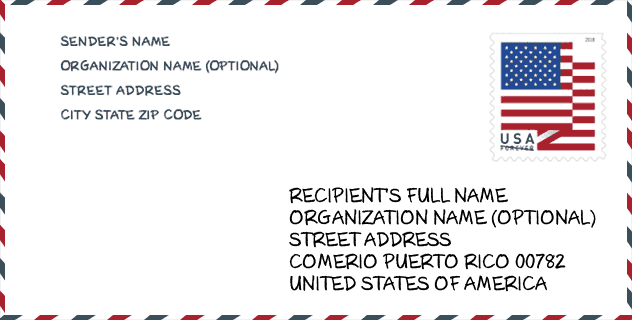
Envelope Example

This is an example of a US zip envelope. You can use a 5-digit zipcode or a detailed 9-digit zipcode to copy the mail in the following address format.
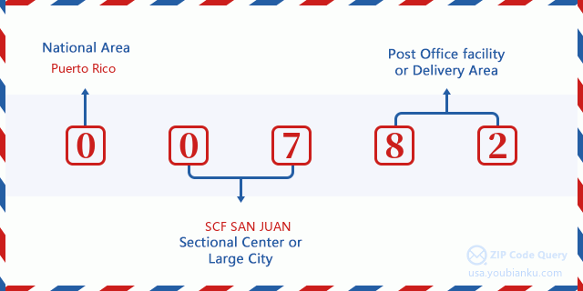
00782 Basic Meaning
What does each digit of ZIP Code 00782 stands for? The first digit designates a national area, which ranges from zero for the Northeast to nine for the far West. The 2-3 digits are the code of a sectional center facility in that region. The last two digits designate small post offices or postal zones.
Online Map

This is online map of the address Urb Sabana Del Palmar, Puerto Rico, United States. You may use button to move and zoom in / out. The map information is for reference only.
School

This is the ZIP Code 00782 - School page list. Its detail School Name, Address, City, State, ZIP Code is as below.
| School Name | Address | City | State | Grades | ZIP Code |
|---|---|---|---|---|---|
| INES M. MENDOZA DE MUNOZ MARIN | CARR 156 KM 26 BO. PALOMAS SECTOR MANUEL ESPINA | COMERIO | PR | UG | 00782 |
| JUANA COLON | CARR 778 BDA. PASARELL. SECTOR INDUSTRIAL | COMERIO | PR | UG | 00782 |
| ESCUELA ESPECIALIZADA EN BEISBOL-MANUEL CRUZ MACEIRA | URB LA PLATA CALLE 6 BO PINAS ABAJO | COMERIO | PR | UG | 00782 |
| SU RAMON ALEJANDRO AYALA | CARR. 779 Km. 5 HM 3 BO PALOMAS | COMERIO | PR | UG | 00782 |
| SU OSCAR PORRATA DORIA | CARR 156 RAMAL 776 BO RIO HONDO I | COMERIO | PR | UG | 00782 |
| SU MARIA C. SANTIAGO | CARR 172 KM 1 HM 5 BO. NARANJO SECTOR SABANA | COMERIO | PR | UG | 00782 |
| CLAUDIO FERRER COTTO | CARR 156 URB SABANA DEL PALMAR 826 PALMA REAL | COMERIO | PR | UG | 00782 |
| SUPERIOR VOCACIONAL NUEVA | CALLE GEORGETTI NUM.42 | COMERIO | PR | UG | 00782 |
| LUIS MUNOZ MARIN | CARR.775 RAMAL 7774 KM 0 HM 4 BO PINAS SECTOR LA MORA | COMERIO | PR | UG | 00782 |
Population for ZIP Code 00782

What is the total population in ZIP Code 00782? Below is detail information.
- Population for ZIP Code 00782: 13,100
- 2010 Population: 19,304
The 2020 demographic statistics are in progress. The current population in ZIP code 00782 is 13,100, and the population in 2010 is 19,304.
Gender

In all the statistical population, the male population is 9,593, the female population is 9,711.
- Male Population: 9,593
- Female Population: 9,711
Race

In all the statistical population, the male population is 9,593, the female population is 9,711.
- White Population: 15,706
- Black Population: 2,165
- Hispanic Population: 19,222
- Asian Population: 27
- Hawaiian Population: 27
- Indian Population: 310
- Other Population: 1,895
Age

In all the statistical population, the White population is 15,706, the Black population is 2,165, the Hispanic population is 19,222, the Asian population is 27, the Hawaiian population is 27, the Indian Ppopulation is 310 and Other population is 1,895.
- Age's Median: 35.1
- Median of male age: 33.5
- Median of female age: 36.6
Households for ZIP Code 00782
ZIP code 00782 has 6,620 households, with an average number of 2.91 persons per household. The average income per household in Zip code 00782 is 12,492 USD, and the average house value is 92,000 USD.
- Households Per Zipcode: 6,620
- Persons Per Household: 2.91
- Average House Value: 92,000
- Income Per Household: 12,492
Geographic

The latitude of the Zip code 00782 is 18.225014, the longitude is -66.219798, and the elevation is 663. It has land area of 26.644 square miles, and water area of 0.123 square miles. The time zone for ZIP code 00782 is Atlantic (GMT -04:00). Daylight saving time should be observed in the area where the zip code is located.
- Latitude: 18.225014
- Longitude: -66.219798
- Elevation: 663
- Land Area: 26.644
- Water Area: 0.123
- Time Zone: Atlantic (GMT -04:00)
- Day Light Saving: N
Delivery

In the ZIP code 00782, there are 4,502 residential delivery mailboxes and centralized units, and 144 commercial delivery mailbox and centralized units, 2,438 single family deliveries and 1,572 multifamily deliveries, and the box count is 6,501. The main post office has city delivery carrier routes for the ZIP code 00782.
- Delivery Residential: 4,502
- Delivery Business: 144
- Delivery Total: 6,501
- Single Family Delivery Units: 2,438
- Multi Family Delivery Units: 1,572
- City Delivery Indicator: Y


Add new comment