United States ZIP Code: 02911
This is the Rhode Island ZIP Code 02911 page list. Its detail State, County, City, Longitude, Latitude, Envelope Example, Population is as below.
, showcasing a creatively designed postal stamp with state flag, Providence County outline, and local landmark, celebrating the unique culture and history of the area.")
ZIP Code 02911 Information

-
-
Country:
U.S. - United States
State:
State FIPS:
44
Area Code:
ZIP Code:
02911
ZIP Type:
S (Standard)
❓What does S (Standard) mean? A "standard" ZIP Code is what most people think of when they talk about ZIP Codes - essentially a town, city, or a division of a city that has mail service.
ZIP Code 02911 - City

This is the city information corresponding to 02911:
| State | County | City | City Type ?In many cases, a ZIP Code can have multiple "names", meaning cities, towns, or subdivisions, in its boundaries. However, it will ALWAYS have exactly 1 "default" name. D - Default - This is the "preferred" name - by the USPS - for a city. Each ZIP Code has one - and only one - "default" name. In most cases, this is what people who live in that area call the city as well. A - Acceptable - This name can be used for mailing purposes. Often times alternative names are large neighborhoods or sections of the city/town. In some cases a ZIP Code may have several "acceptable" names which is used to group towns under one ZIP Code. N - Not Acceptable - A "not acceptable" name is, in many cases, a nickname that residents give that location. According to the USPS, you should NOT send mail to that ZIP Code using the "not acceptable" name when mailing. | ZIP Code |
|---|---|---|---|---|
| RI | Providence | Centerdale | N (Not Acceptable) | 02911 |
| RI | Providence | Centredale | N (Not Acceptable) | 02911 |
| RI | Providence | N Providence | A (Acceptable) | 02911 |
| RI | Providence | No Providence | N (Not Acceptable) | 02911 |
| RI | Providence | North Providence | D (Default) | 02911 |
| RI | Providence | Providence | A (Acceptable) | 02911 |
❓What does D (Default) mean? This is the "preferred" name - by the USPS - for a city. Each ZIP Code has one - and only one - "default" name. In most cases, this is what people who live in that area call the city as well.
❓What does A (Acceptable) mean? This name can be used for mailing purposes. Often times alternative names are large neighborhoods or sections of the city/town. In some cases a ZIP Code may have several "acceptable" names which is used to group towns under one ZIP Code.
❓What does N (Not Acceptable) mean? A "not acceptable" name is, in many cases, a nickname that residents give that location. According to the USPS, you should NOT send mail to that ZIP Code using the "not acceptable" name when mailing.
ZIP Code 02911 Plus 4
ZIP Code 5 plus 4 is the extension of 5-digit zip code, It can be used to locate a more detailed location. The last four digits designate segment or one side of a street or an apartment. You can find the ZIP+4 code and corresponding address of the zip code 02911 below.
| ZIP Code 5 Plus 4 | Address |
|---|---|
| 02911-0001 | PO BOX 113801, NORTH PROVIDENCE, RI |
| 02911-0061 | PO BOX 113861, NORTH PROVIDENCE, RI |
| 02911-0121 | PO BOX 113921, NORTH PROVIDENCE, RI |
| 02911-0181 | PO BOX 113981, NORTH PROVIDENCE, RI |
| 02911-0241 | PO BOX 114041, NORTH PROVIDENCE, RI |
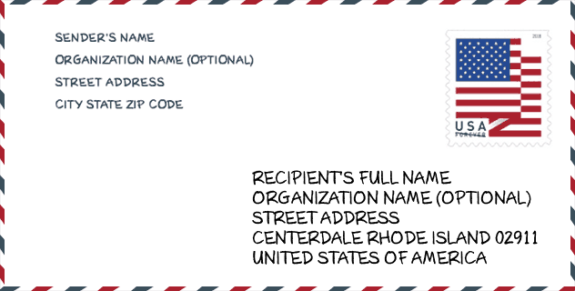
Envelope Example

This is an example of a US zip envelope. You can use a 5-digit zipcode or a detailed 9-digit zipcode to copy the mail in the following address format.
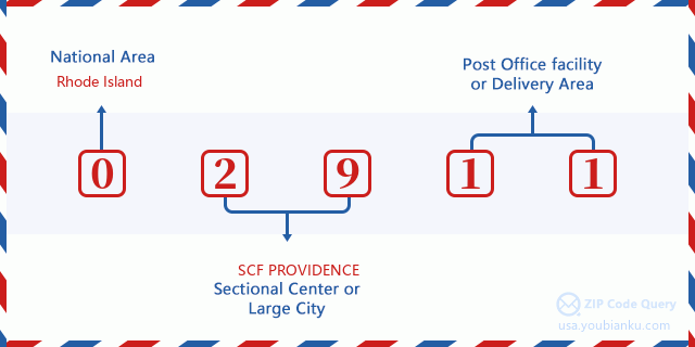
02911 Basic Meaning
What does each digit of ZIP Code 02911 stands for? The first digit designates a national area, which ranges from zero for the Northeast to nine for the far West. The 2-3 digits are the code of a sectional center facility in that region. The last two digits designate small post offices or postal zones.
Online Map

This is online map of the address Providence, Rhode Island, United States. You may use button to move and zoom in / out. The map information is for reference only.
School

This is the ZIP Code 02911 - School page list. Its detail School Name, Address, City, State, ZIP Code is as below.
| School Name | Address | City | State | Grades | ZIP Code |
|---|---|---|---|---|---|
| Centredale School | 41 Angell Avenue | North Providence | RI | UG | 02911 |
| Greystone School | 100 Morgan Avenue | North Providence | RI | UG | 02911 |
| James L. McGuire School | 55 Central Avenue | North Providence | RI | UG | 02911 |
| Dr. Edward Ricci School | 51 Intervale Avenue | North Providence | RI | UG | 02911 |
Population for ZIP Code 02911

What is the total population in ZIP Code 02911? Below is detail information.
- Population for ZIP Code 02911: 15,560
- 2010 Population: 15,574
The 2020 demographic statistics are in progress. The current population in ZIP code 02911 is 15,560, and the population in 2010 is 15,574.
Gender

In all the statistical population, the male population is 7,140, the female population is 8,434.
- Male Population: 7,140
- Female Population: 8,434
Race

In all the statistical population, the male population is 7,140, the female population is 8,434.
- White Population: 13,943
- Black Population: 907
- Hispanic Population: 1,279
- Asian Population: 376
- Hawaiian Population: 51
- Indian Population: 169
- Other Population: 650
Age

In all the statistical population, the White population is 13,943, the Black population is 907, the Hispanic population is 1,279, the Asian population is 376, the Hawaiian population is 51, the Indian Ppopulation is 169 and Other population is 650.
- Age's Median: 39.2
- Median of male age: 37.8
- Median of female age: 40.6
Households for ZIP Code 02911
ZIP code 02911 has 6,525 households, with an average number of 2.26 persons per household. The average income per household in Zip code 02911 is 58,014 USD, and the average house value is 202,400 USD.
- Households Per Zipcode: 6,525
- Persons Per Household: 2.26
- Average House Value: 202,400
- Income Per Household: 58,014
Geographic

The latitude of the Zip code 02911 is 41.853544, the longitude is -71.472467, and the elevation is 127. It has land area of 2.491 square miles, and water area of 0.039 square miles. The time zone for ZIP code 02911 is Eastern (GMT -05:00). Daylight saving time should be observed in the area where the zip code is located.
- Latitude: 41.853544
- Longitude: -71.472467
- Elevation: 127
- Land Area: 2.491
- Water Area: 0.039
- Time Zone: Eastern (GMT -05:00)
- Region: Northeast
- Division: New England
- Day Light Saving: Y
Congressional District

The Congressional District for ZIP code 02911 is Rhode Island's 1st|2nd congressional district, the Congressional Land Area is 268.49|765.32 square mile.
- Congressional District: 1st|2nd
- Congressional Land Area: 268.49|765.32
Delivery

In the ZIP code 02911, there are 6,885 residential delivery mailboxes and centralized units, and 262 commercial delivery mailbox and centralized units, 5,000 single family deliveries and 1,079 multifamily deliveries, and the box count is 7,873. The main post office has city delivery carrier routes for the ZIP code 02911.
- Delivery Residential: 6,885
- Delivery Business: 262
- Delivery Total: 7,873
- Single Family Delivery Units: 5,000
- Multi Family Delivery Units: 1,079
- City Delivery Indicator: Y
Business

In ZIP code 02911, the number of business is 222, the number of employee is 2,015, the business first quarter payroll is 14,190,000 USD, the business annual payroll is 59,581,000 USD.
- Number Of Businesses: 222
- Number Of Employees: 2,015
- Business First Quarter Payroll: 14,190,000
- Business Annual Payroll: 59,581,000


Add new comment