ZIP Code: 07885, Wharton, NJ
ZIP Code 07885 is located in Wharton, New Jersey. Its detail State, County, City, Longitude, Latitude, Envelope Example, Population is as below.

ZIP Code 07885 Information

-
-
Country:
U.S. - United States
State:
County FIPS:
34027
County:
City:
City Type ?In many cases, a ZIP Code can have multiple "names", meaning cities, towns, or subdivisions, in its boundaries. However, it will ALWAYS have exactly 1 "default" name. D - Default - This is the "preferred" name - by the USPS - for a city. Each ZIP Code has one - and only one - "default" name. In most cases, this is what people who live in that area call the city as well. A - Acceptable - This name can be used for mailing purposes. Often times alternative names are large neighborhoods or sections of the city/town. In some cases a ZIP Code may have several "acceptable" names which is used to group towns under one ZIP Code. N - Not Acceptable - A "not acceptable" name is, in many cases, a nickname that residents give that location. According to the USPS, you should NOT send mail to that ZIP Code using the "not acceptable" name when mailing.:
D (Default)
ZIP Code:
07885
❓What does D (Default) mean? This is the "preferred" name - by the USPS - for a city. Each ZIP Code has one - and only one - "default" name. In most cases, this is what people who live in that area call the city as well.
-


-
Iconic US Landmark Legacy Designs
Get PNG, SVG, EPS, AI, PDF Versions at Just $0.1
 Download Now
-


ZipCodeCraft
ZIP Code 07885 Plus 4
ZIP Code 5 plus 4 is the extension of 5-digit zip code, It can be used to locate a more detailed location. The last four digits designate segment or one side of a street or an apartment. You can find the ZIP+4 code and corresponding address of the zip code 07885 below.
| ZIP Code 5 Plus 4 | Address |
|---|---|
| 07885-0001 | PO BOX 1, WHARTON, NJ |
| 07885-0121 | PO BOX 121, WHARTON, NJ |
| 07885-0241 | PO BOX 241, WHARTON, NJ |
| 07885-0361 | PO BOX 361, WHARTON, NJ |
| 07885-0401 | PO BOX 401, WHARTON, NJ |
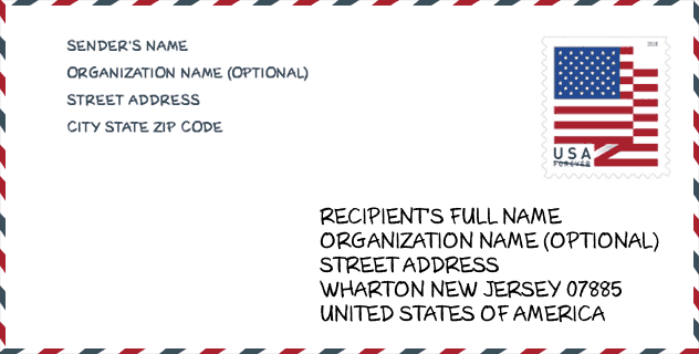
Envelope Example

This is an example of a US zip envelope. You can use a 5-digit zipcode or a detailed 9-digit zipcode to copy the mail in the following address format.
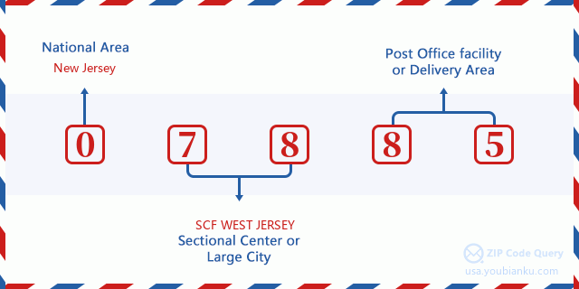
07885 Basic Meaning
What does each digit of ZIP Code 07885 stands for? The first digit designates a national area, which ranges from zero for the Northeast to nine for the far West. The 2-3 digits are the code of a sectional center facility in that region. The last two digits designate small post offices or postal zones.
Online Map

This is online map of the address Wharton, New Jersey, United States. You may use button to move and zoom in / out. The map information is for reference only.
Library

This is the ZIP Code 07885 - Library page list. Its detail Library Name, Address, City, State, ZIP Code, Phone is as below.
| Name | Address | City | State | ZIP Code | Phone |
|---|---|---|---|---|---|
| WHARTON PUBLIC LIBRARY | 15 S. MAIN STREET | WHARTON | NJ | 07885 | (973) 361-1333 |
| WHARTON PUBLIC LIBRARY | 15 S. MAIN STREET | WHARTON | NJ | 07885 | (201) 361-1333 |
School

This is the ZIP Code 07885 - School page list. Its detail School Name, Address, City, State, ZIP Code is as below.
| School Name | Address | City | State | Grades | ZIP Code |
|---|---|---|---|---|---|
| Arthur Stanlick Elementary School | 121 B SHAWNEE TRAIL | LK SHAWNEE JEFFERSON TWSP | NJ | UG | 07885 |
| Catherine A Dwyer Elementary School | 665 MT HOPE AVENUE | WHARTON | NJ | UG | 07885 |
Population for ZIP Code 07885

What is the total population in ZIP Code 07885? Below is detail information.
- Population for ZIP Code 07885: 12,387
- 2010 Population: 10,078
The 2020 demographic statistics are in progress. The current population in ZIP code 07885 is 12,387, and the population in 2010 is 10,078.
Gender

In all the statistical population, the male population is 4,944, the female population is 5,134.
- Male Population: 4,944
- Female Population: 5,134
Race

In all the statistical population, the male population is 4,944, the female population is 5,134.
- White Population: 8,501
- Black Population: 441
- Hispanic Population: 2,915
- Asian Population: 564
- Hawaiian Population: 15
- Indian Population: 69
- Other Population: 849
Age

In all the statistical population, the White population is 8,501, the Black population is 441, the Hispanic population is 2,915, the Asian population is 564, the Hawaiian population is 15, the Indian Ppopulation is 69 and Other population is 849.
- Age's Median: 39.4
- Median of male age: 38.0
- Median of female age: 41.2
Households for ZIP Code 07885
ZIP code 07885 has 3,743 households, with an average number of 2.69 persons per household. The average income per household in Zip code 07885 is 73,763 USD, and the average house value is 292,800 USD.
- Households Per Zipcode: 3,743
- Persons Per Household: 2.69
- Average House Value: 292,800
- Income Per Household: 73,763
Geographic

The latitude of the Zip code 07885 is 40.937489, the longitude is -74.580866, and the elevation is 880. It has land area of 15.083 square miles, and water area of 0.704 square miles. The time zone for ZIP code 07885 is Eastern (GMT -05:00). Daylight saving time should be observed in the area where the zip code is located.
- Latitude: 40.937489
- Longitude: -74.580866
- Elevation: 880
- Land Area: 15.083
- Water Area: 0.704
- Time Zone: Eastern (GMT -05:00)
- Region: Northeast
- Division: Middle Atlantic
- Day Light Saving: Y
Congressional District

The Congressional District for ZIP code 07885 is New Jersey's 07th|11th congressional district, the Congressional Land Area is 970.19|504.97 square mile.
- Congressional District: 07th|11th
- Congressional Land Area: 970.19|504.97
Delivery

In the ZIP code 07885, there are 4,605 residential delivery mailboxes and centralized units, and 245 commercial delivery mailbox and centralized units, 3,337 single family deliveries and 734 multifamily deliveries, and the box count is 5,865. The main post office has city delivery carrier routes for the ZIP code 07885.
- Delivery Residential: 4,605
- Delivery Business: 245
- Delivery Total: 5,865
- Single Family Delivery Units: 3,337
- Multi Family Delivery Units: 734
- City Delivery Indicator: Y
Business

In ZIP code 07885, the number of business is 237, the number of employee is 3,573, the business first quarter payroll is 40,587,000 USD, the business annual payroll is 176,224,000 USD.
- Number Of Businesses: 237
- Number Of Employees: 3,573
- Business First Quarter Payroll: 40,587,000
- Business Annual Payroll: 176,224,000


Add new comment