United States ZIP Code: 08022
This is the New Jersey ZIP Code 08022 page list. Its detail State, County, City, Longitude, Latitude, Envelope Example, Population is as below.

ZIP Code 08022 Information

-
-
Country:
U.S. - United States
State:
State FIPS:
34
Area Code:
ZIP Code:
08022
ZIP Type:
S (Standard)
❓What does S (Standard) mean? A "standard" ZIP Code is what most people think of when they talk about ZIP Codes - essentially a town, city, or a division of a city that has mail service.
-


-
Iconic US Landmark Legacy Designs
Get PNG, SVG, EPS, AI, PDF Versions at Just $0.1
 Download Now
-


ZipCodeCraft
ZIP Code 08022 - City

This is the city information corresponding to 08022:
| State | County | City | City Type ?In many cases, a ZIP Code can have multiple "names", meaning cities, towns, or subdivisions, in its boundaries. However, it will ALWAYS have exactly 1 "default" name. D - Default - This is the "preferred" name - by the USPS - for a city. Each ZIP Code has one - and only one - "default" name. In most cases, this is what people who live in that area call the city as well. A - Acceptable - This name can be used for mailing purposes. Often times alternative names are large neighborhoods or sections of the city/town. In some cases a ZIP Code may have several "acceptable" names which is used to group towns under one ZIP Code. N - Not Acceptable - A "not acceptable" name is, in many cases, a nickname that residents give that location. According to the USPS, you should NOT send mail to that ZIP Code using the "not acceptable" name when mailing. | ZIP Code |
|---|---|---|---|---|
| NJ | Burlington | Columbus | D (Default) | 08022 |
| NJ | Burlington | Mansfield | N (Not Acceptable) | 08022 |
❓What does D (Default) mean? This is the "preferred" name - by the USPS - for a city. Each ZIP Code has one - and only one - "default" name. In most cases, this is what people who live in that area call the city as well.
❓What does N (Not Acceptable) mean? A "not acceptable" name is, in many cases, a nickname that residents give that location. According to the USPS, you should NOT send mail to that ZIP Code using the "not acceptable" name when mailing.
ZIP Code 08022 Plus 4
ZIP Code 5 plus 4 is the extension of 5-digit zip code, It can be used to locate a more detailed location. The last four digits designate segment or one side of a street or an apartment. You can find the ZIP+4 code and corresponding address of the zip code 08022 below.
| ZIP Code 5 Plus 4 | Address |
|---|---|
| 08022-0001 | PO BOX 1, COLUMBUS, NJ |
| 08022-0121 | PO BOX 121, COLUMBUS, NJ |
| 08022-0198 | PO BOX 198, COLUMBUS, NJ |
| 08022-0201 | PO BOX 201, COLUMBUS, NJ |
| 08022-0207 | PO BOX 207, COLUMBUS, NJ |
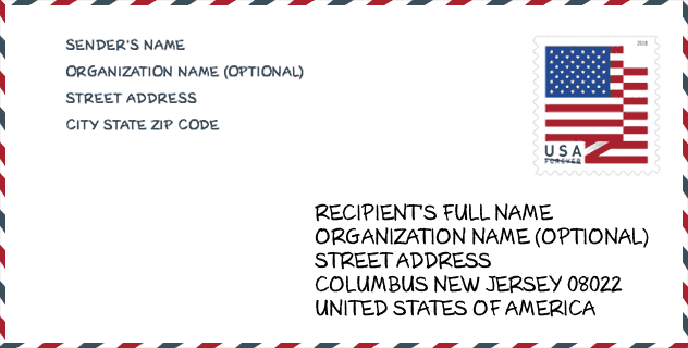
Envelope Example

This is an example of a US zip envelope. You can use a 5-digit zipcode or a detailed 9-digit zipcode to copy the mail in the following address format.
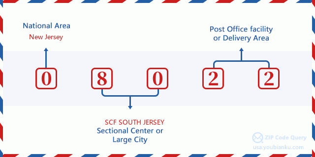
08022 Basic Meaning
What does each digit of ZIP Code 08022 stands for? The first digit designates a national area, which ranges from zero for the Northeast to nine for the far West. The 2-3 digits are the code of a sectional center facility in that region. The last two digits designate small post offices or postal zones.
Online Map

This is online map of the address Mansfield, New Jersey, United States. You may use button to move and zoom in / out. The map information is for reference only.
Museum

This is the ZIP Code 08022 - Museum page list. Its detail Museum Name, Street, City, State, ZIP Code, Phone is as below.
- Name: MANSFIELD TOWNSHIP HISTORICAL SOCIETY
- Street: 4 FITZGERALD LANE
- City: COLUMBUS
- State: NJ
- ZIP Code: 08022
- Phone: (609) 298-4174
School

This is the ZIP Code 08022 - School page list. Its detail School Name, Address, City, State, ZIP Code is as below.
| School Name | Address | City | State | Grades | ZIP Code |
|---|---|---|---|---|---|
| Mansfield Township Elementary School | 200 MANSFIELD ROAD EAST | COLUMBUS | NJ | UG | 08022 |
| Northern Burlington County Regional Middle School | 180 MANSFIELD ROAD EAST | COLUMBUS | NJ | UG | 08022 |
Population for ZIP Code 08022

What is the total population in ZIP Code 08022? Below is detail information.
- Population for ZIP Code 08022: 9,451
- 2010 Population: 8,783
The 2020 demographic statistics are in progress. The current population in ZIP code 08022 is 9,451, and the population in 2010 is 8,783.
Gender

In all the statistical population, the male population is 4,170, the female population is 4,613.
- Male Population: 4,170
- Female Population: 4,613
Race

In all the statistical population, the male population is 4,170, the female population is 4,613.
- White Population: 7,106
- Black Population: 950
- Hispanic Population: 440
- Asian Population: 732
- Hawaiian Population: 19
- Indian Population: 56
- Other Population: 106
Age

In all the statistical population, the White population is 7,106, the Black population is 950, the Hispanic population is 440, the Asian population is 732, the Hawaiian population is 19, the Indian Ppopulation is 56 and Other population is 106.
- Age's Median: 48.7
- Median of male age: 47.0
- Median of female age: 50.3
Households for ZIP Code 08022
ZIP code 08022 has 3,432 households, with an average number of 2.56 persons per household. The average income per household in Zip code 08022 is 94,864 USD, and the average house value is 309,500 USD.
- Households Per Zipcode: 3,432
- Persons Per Household: 2.56
- Average House Value: 309,500
- Income Per Household: 94,864
Geographic

The latitude of the Zip code 08022 is 40.059442, the longitude is -74.696100, and the elevation is 46. It has land area of 21.939 square miles, and water area of 0.079 square miles. The time zone for ZIP code 08022 is Eastern (GMT -05:00). Daylight saving time should be observed in the area where the zip code is located.
- Latitude: 40.059442
- Longitude: -74.696100
- Elevation: 46
- Land Area: 21.939
- Water Area: 0.079
- Time Zone: Eastern (GMT -05:00)
- Region: Northeast
- Division: Middle Atlantic
- Day Light Saving: Y
Congressional District

The Congressional District for ZIP code 08022 is New Jersey's 3rd congressional district, the Congressional Land Area is 899.7 square mile.
- Congressional District: 3rd
- Congressional Land Area: 899.7
Delivery

In the ZIP code 08022, there are 3,692 residential delivery mailboxes and centralized units, and 131 commercial delivery mailbox and centralized units, 3,595 single family deliveries and 0 multifamily deliveries, and the box count is 11,806. The main post office does not have city delivery carrier routes for the ZIP code 08022.
- Delivery Residential: 3,692
- Delivery Business: 131
- Delivery Total: 11,806
- Single Family Delivery Units: 3,595
- Multi Family Delivery Units: 0
- City Delivery Indicator: N
Business

In ZIP code 08022, the number of business is 168, the number of employee is 989, the business first quarter payroll is 10,387,000 USD, the business annual payroll is 41,489,000 USD.
- Number Of Businesses: 168
- Number Of Employees: 989
- Business First Quarter Payroll: 10,387,000
- Business Annual Payroll: 41,489,000


Add new comment