United States ZIP Code: 08057
This is the New Jersey ZIP Code 08057 page list. Its detail State, County, City, Longitude, Latitude, Envelope Example, Population is as below.

ZIP Code 08057 Information

-
-
Country:
U.S. - United States
State:
State FIPS:
34
ZIP Code:
08057
ZIP Type:
S (Standard)
❓What does S (Standard) mean? A "standard" ZIP Code is what most people think of when they talk about ZIP Codes - essentially a town, city, or a division of a city that has mail service.
ZIP Code 08057 - City

This is the city information corresponding to 08057:
| State | County | City | City Type ?In many cases, a ZIP Code can have multiple "names", meaning cities, towns, or subdivisions, in its boundaries. However, it will ALWAYS have exactly 1 "default" name. D - Default - This is the "preferred" name - by the USPS - for a city. Each ZIP Code has one - and only one - "default" name. In most cases, this is what people who live in that area call the city as well. A - Acceptable - This name can be used for mailing purposes. Often times alternative names are large neighborhoods or sections of the city/town. In some cases a ZIP Code may have several "acceptable" names which is used to group towns under one ZIP Code. N - Not Acceptable - A "not acceptable" name is, in many cases, a nickname that residents give that location. According to the USPS, you should NOT send mail to that ZIP Code using the "not acceptable" name when mailing. | ZIP Code |
|---|---|---|---|---|
| NJ | Burlington | Lenola | N (Not Acceptable) | 08057 |
| NJ | Burlington | Moorestown | D (Default) | 08057 |
❓What does D (Default) mean? This is the "preferred" name - by the USPS - for a city. Each ZIP Code has one - and only one - "default" name. In most cases, this is what people who live in that area call the city as well.
❓What does N (Not Acceptable) mean? A "not acceptable" name is, in many cases, a nickname that residents give that location. According to the USPS, you should NOT send mail to that ZIP Code using the "not acceptable" name when mailing.
ZIP Code 08057 Plus 4
ZIP Code 5 plus 4 is the extension of 5-digit zip code, It can be used to locate a more detailed location. The last four digits designate segment or one side of a street or an apartment. You can find the ZIP+4 code and corresponding address of the zip code 08057 below.
| ZIP Code 5 Plus 4 | Address |
|---|---|
| 08057-0001 | PO BOX 1, MOORESTOWN, NJ |
| 08057-0018 | PO BOX 1018, MOORESTOWN, NJ |
| 08057-0021 | PO BOX 21, MOORESTOWN, NJ |
| 08057-0061 | PO BOX 61, MOORESTOWN, NJ |
| 08057-0120 | PO BOX 120, MOORESTOWN, NJ |
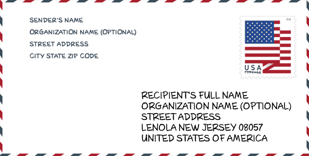
Envelope Example

This is an example of a US zip envelope. You can use a 5-digit zipcode or a detailed 9-digit zipcode to copy the mail in the following address format.
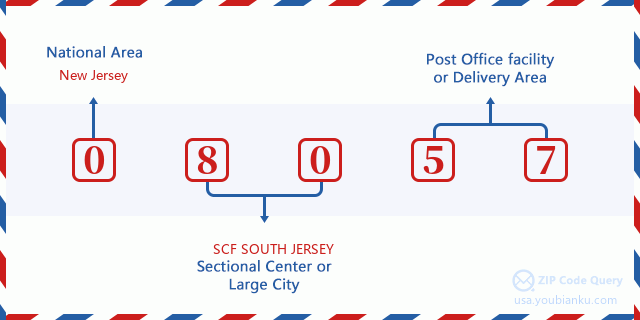
08057 Basic Meaning
What does each digit of ZIP Code 08057 stands for? The first digit designates a national area, which ranges from zero for the Northeast to nine for the far West. The 2-3 digits are the code of a sectional center facility in that region. The last two digits designate small post offices or postal zones.
Online Map

This is online map of the address Moorestown, New Jersey, United States. You may use button to move and zoom in / out. The map information is for reference only.
University

This is the ZIP Code 08057 - University page list. Its detail university Name, Street, City, State, ZIP Code, Phone is as below.
| Name | Street | City | State | ZIP Code | Phone |
| Lincoln Technical Institute-Moorestown | 308 Route 38 W | Moorestown | NJ | 08057 | (856) 722-9333 x42200 |
Library

This is the ZIP Code 08057 - Library page list. Its detail Library Name, Address, City, State, ZIP Code, Phone is as below.
| Name | Address | City | State | ZIP Code | Phone |
|---|---|---|---|---|---|
| MOORESTOWN LIBRARY | 111 W. SECOND STREET | MOORESTOWN | NJ | 08057 | (856) 234-0333 |
| MOORESTOWN LIBRARY | 111 W. SECOND STREET | MOORESTOWN | NJ | 08057 | (609) 234-0333 |
School
This is the ZIP Code 08057 - School page list. Its detail School Name, Address, City, State, ZIP Code is as below.
| School Name | Address | City | State | Grades | ZIP Code |
|---|---|---|---|---|---|
| Moorestown Upper Elementary School | 325 BORTON LANDING ROAD | MOORESTOWN | NJ | UG | 08057 |
| George C. Baker Elementary School | 139 W MAPLE AVE | MOORESTOWN | NJ | UG | 08057 |
| Mary E. Roberts Elementary School | 290 CRESCENT AVENUE | MOORESTOWN | NJ | UG | 08057 |
| William Allen Middle School | 801 N STANWICK ROAD | MOORESTOWN | NJ | UG | 08057 |
| South Valley Elementary School | 210 S STANWICK RD | MOORESTOWN | NJ | UG | 08057 |
Population for ZIP Code 08057

What is the total population in ZIP Code 08057? Below is detail information.
- Population for ZIP Code 08057: 21,903
- 2010 Population: 21,090
The 2020 demographic statistics are in progress. The current population in ZIP code 08057 is 21,903, and the population in 2010 is 21,090.
Gender

In all the statistical population, the male population is 10,049, the female population is 11,041.
- Male Population: 10,049
- Female Population: 11,041
Race

In all the statistical population, the male population is 10,049, the female population is 11,041.
- White Population: 18,235
- Black Population: 1,526
- Hispanic Population: 734
- Asian Population: 1,439
- Hawaiian Population: 14
- Indian Population: 137
- Other Population: 230
Age

In all the statistical population, the White population is 18,235, the Black population is 1,526, the Hispanic population is 734, the Asian population is 1,439, the Hawaiian population is 14, the Indian Ppopulation is 137 and Other population is 230.
- Age's Median: 43.4
- Median of male age: 41.7
- Median of female age: 44.6
Households for ZIP Code 08057
ZIP code 08057 has 7,568 households, with an average number of 2.74 persons per household. The average income per household in Zip code 08057 is 140,802 USD, and the average house value is 506,400 USD.
- Households Per Zipcode: 7,568
- Persons Per Household: 2.74
- Average House Value: 506,400
- Income Per Household: 140,802
Geographic

The latitude of the Zip code 08057 is 39.976434, the longitude is -74.943091, and the elevation is 60. It has land area of 15.278 square miles, and water area of 0.203 square miles. The time zone for ZIP code 08057 is Eastern (GMT -05:00). Daylight saving time should be observed in the area where the zip code is located.
- Latitude: 39.976434
- Longitude: -74.943091
- Elevation: 60
- Land Area: 15.278
- Water Area: 0.203
- Time Zone: Eastern (GMT -05:00)
- Region: Northeast
- Division: Middle Atlantic
- Day Light Saving: Y
Congressional District

The Congressional District for ZIP code 08057 is New Jersey's 1st|3rd congressional district, the Congressional Land Area is 350.02|899.7 square mile.
- Congressional District: 1st|3rd
- Congressional Land Area: 350.02|899.7
Delivery

In the ZIP code 08057, there are 7,994 residential delivery mailboxes and centralized units, and 1,015 commercial delivery mailbox and centralized units, 7,064 single family deliveries and 533 multifamily deliveries, and the box count is 9,284. The main post office has city delivery carrier routes for the ZIP code 08057.
- Delivery Residential: 7,994
- Delivery Business: 1,015
- Delivery Total: 9,284
- Single Family Delivery Units: 7,064
- Multi Family Delivery Units: 533
- City Delivery Indicator: Y
Business

In ZIP code 08057, the number of business is 993, the number of employee is 24,637, the business first quarter payroll is 397,684,000 USD, the business annual payroll is 1,634,799,000 USD.
- Number Of Businesses: 993
- Number Of Employees: 24,637
- Business First Quarter Payroll: 397,684,000
- Business Annual Payroll: 1,634,799,000


Add new comment