United States ZIP Code: 08060
This is the New Jersey ZIP Code 08060 page list. Its detail State, County, City, Longitude, Latitude, Envelope Example, Population is as below.

ZIP Code 08060 Information

-
-
Country:
U.S. - United States
State:
State FIPS:
34
Area Code:
ZIP Code:
08060
ZIP Type:
S (Standard)
❓What does S (Standard) mean? A "standard" ZIP Code is what most people think of when they talk about ZIP Codes - essentially a town, city, or a division of a city that has mail service.
ZIP Code 08060 - City

This is the city information corresponding to 08060:
| State | County | City | City Type ?In many cases, a ZIP Code can have multiple "names", meaning cities, towns, or subdivisions, in its boundaries. However, it will ALWAYS have exactly 1 "default" name. D - Default - This is the "preferred" name - by the USPS - for a city. Each ZIP Code has one - and only one - "default" name. In most cases, this is what people who live in that area call the city as well. A - Acceptable - This name can be used for mailing purposes. Often times alternative names are large neighborhoods or sections of the city/town. In some cases a ZIP Code may have several "acceptable" names which is used to group towns under one ZIP Code. N - Not Acceptable - A "not acceptable" name is, in many cases, a nickname that residents give that location. According to the USPS, you should NOT send mail to that ZIP Code using the "not acceptable" name when mailing. | ZIP Code |
|---|---|---|---|---|
| NJ | Burlington | Eastamptn Twp | A (Acceptable) | 08060 |
| NJ | Burlington | Eastampton | A (Acceptable) | 08060 |
| NJ | Burlington | Eastampton Township | A (Acceptable) | 08060 |
| NJ | Burlington | Mount Holly | D (Default) | 08060 |
| NJ | Burlington | Mount Holly Township | N (Not Acceptable) | 08060 |
| NJ | Burlington | Westampton | A (Acceptable) | 08060 |
| NJ | Burlington | Westampton Township | N (Not Acceptable) | 08060 |
❓What does D (Default) mean? This is the "preferred" name - by the USPS - for a city. Each ZIP Code has one - and only one - "default" name. In most cases, this is what people who live in that area call the city as well.
❓What does A (Acceptable) mean? This name can be used for mailing purposes. Often times alternative names are large neighborhoods or sections of the city/town. In some cases a ZIP Code may have several "acceptable" names which is used to group towns under one ZIP Code.
❓What does N (Not Acceptable) mean? A "not acceptable" name is, in many cases, a nickname that residents give that location. According to the USPS, you should NOT send mail to that ZIP Code using the "not acceptable" name when mailing.
ZIP Code 08060 Plus 4
ZIP Code 5 plus 4 is the extension of 5-digit zip code, It can be used to locate a more detailed location. The last four digits designate segment or one side of a street or an apartment. You can find the ZIP+4 code and corresponding address of the zip code 08060 below.
| ZIP Code 5 Plus 4 | Address |
|---|---|
| 08060-0001 | PO BOX 1, MOUNT HOLLY, NJ |
| 08060-0061 | PO BOX 61, MOUNT HOLLY, NJ |
| 08060-0121 | PO BOX 121, MOUNT HOLLY, NJ |
| 08060-0181 | PO BOX 181, MOUNT HOLLY, NJ |
| 08060-0261 | PO BOX 261, MOUNT HOLLY, NJ |
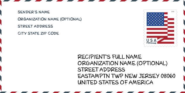
Envelope Example

This is an example of a US zip envelope. You can use a 5-digit zipcode or a detailed 9-digit zipcode to copy the mail in the following address format.
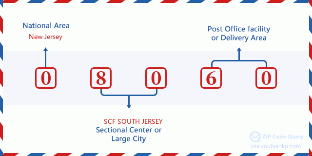
08060 Basic Meaning
What does each digit of ZIP Code 08060 stands for? The first digit designates a national area, which ranges from zero for the Northeast to nine for the far West. The 2-3 digits are the code of a sectional center facility in that region. The last two digits designate small post offices or postal zones.
Online Map

This is online map of the address Westampton Township, New Jersey, United States. You may use button to move and zoom in / out. The map information is for reference only.
Hospital

This is the ZIP Code 08060 - Hospital page list. Its detail Hospital Name, Street, City, State, ZIP Code, Phone is as below.
| Name | Address | City | State | ZIP Code | Phone |
|---|---|---|---|---|---|
| HAMPTON BEHAVIORAL HEALTH SYSTEM | 650 RANCOCAS ROAD | WESTAMPTON | NJ | 08060 | (609) 267-7000 |
| VIRTUA MEMORIAL HOSPITAL OF BURLINGTON COUNTY | 175 MADISON AVE | MOUNT HOLLY | NJ | 08060 | (609) 267-0700 |
Museum

This is the ZIP Code 08060 - Museum page list. Its detail Museum Name, Street, City, State, ZIP Code, Phone is as below.
| Name | Street | City | State | ZIP Code | Phone |
| JOHN WOOLMAN MEMORIAL | 99 BRANCH ST | MOUNT HOLLY | NJ | 08060 | (609) 267-3226 |
| AMERICAN INDIAN HERITAGE MUSEUM | 730 RANCOCAS RD | WESTAMPTON | NJ | 08060 | (609) 261-4747 |
| NATIONAL GUARD MILITIA MUSEUM OF NEW JERSEY | 387 | MOUNT HOLLY | NJ | 08060 | |
| MOUNT HOLLY HISTORICAL SOCIETY | BOX 4081 | MOUNT HOLLY | NJ | 08060 | (609) 267-8844 |
| HISTORICAL MILITARY IMPRESSIONS | 3 MEADOW LANE | MOUNT HOLLY | NJ | 08060 | |
| STUDENT GALLERY | 1 HIGH STREET | MOUNT HOLLY | NJ | 08060 | (609) 267-5618 |
Library

This is the ZIP Code 08060 - Library page list. Its detail Library Name, Address, City, State, ZIP Code, Phone is as below.
| Name | Address | City | State | ZIP Code | Phone |
|---|---|---|---|---|---|
| BURLINGTON BOOKMOBILE | W. WOODLANE ROAD | MOUNT HOLLY | NJ | 08060 | (609) 267-9660 |
| BURLINGTON COUNTY LIBRARY | 5 PIONEER BLVD | WESTAMPTON | NJ | 08060 | (609) 267-9660 |
| BURLINGTON COUNTY LIBRARY | W. WOODLANE ROAD | MOUNT HOLLY | NJ | 08060 | (609) 267-9660 |
| MOUNT HOLLY LIBRARY & LYCEUM | 307 HIGH STREET | MOUNT HOLLY | NJ | 08060 | (609) 267-7111 |
| MOUNT HOLLY LIBRARY AND LYCEUM | 307 HIGH STREET | MOUNT HOLLY | NJ | 08060 | (609) 267-7111 |
School

This is the ZIP Code 08060 - School page list. Its detail School Name, Address, City, State, ZIP Code is as below.
| School Name | Address | City | State | Grades | ZIP Code |
|---|---|---|---|---|---|
| Capital Academy | 20 PIONEER BLVD | MT HOLLY | NJ | UG | 08060 |
| Burlington Regional School | 704 WOODLANE RD | MT HOLLY | NJ | UG | 08060 |
| John Brainerd Elementary School | 100 WOLLNER DR | MOUNT HOLLY | NJ | UG | 08060 |
| F. W. Holbein Middle School | 333 LEVIS DRIVE | MOUNT HOLLY | NJ | UG | 08060 |
| Holly Hills Elementary School | 500 OGDEN DRIVE | WESTAMPTON | NJ | UG | 08060 |
Population for ZIP Code 08060

What is the total population in ZIP Code 08060? Below is detail information.
- Population for ZIP Code 08060: 26,984
- 2010 Population: 24,713
The 2020 demographic statistics are in progress. The current population in ZIP code 08060 is 26,984, and the population in 2010 is 24,713.
Gender

In all the statistical population, the male population is 12,102, the female population is 12,611.
- Male Population: 12,102
- Female Population: 12,611
Race

In all the statistical population, the male population is 12,102, the female population is 12,611.
- White Population: 17,172
- Black Population: 6,183
- Hispanic Population: 2,499
- Asian Population: 1,277
- Hawaiian Population: 39
- Indian Population: 316
- Other Population: 921
Age

In all the statistical population, the White population is 17,172, the Black population is 6,183, the Hispanic population is 2,499, the Asian population is 1,277, the Hawaiian population is 39, the Indian Ppopulation is 316 and Other population is 921.
- Age's Median: 38.1
- Median of male age: 36.3
- Median of female age: 39.6
Households for ZIP Code 08060
ZIP code 08060 has 8,990 households, with an average number of 2.68 persons per household. The average income per household in Zip code 08060 is 86,706 USD, and the average house value is 230,400 USD.
- Households Per Zipcode: 8,990
- Persons Per Household: 2.68
- Average House Value: 230,400
- Income Per Household: 86,706
Geographic

The latitude of the Zip code 08060 is 40.014698, the longitude is -74.789695, and the elevation is 41. It has land area of 22.199 square miles, and water area of 0.318 square miles. The time zone for ZIP code 08060 is Eastern (GMT -05:00). Daylight saving time should be observed in the area where the zip code is located.
- Latitude: 40.014698
- Longitude: -74.789695
- Elevation: 41
- Land Area: 22.199
- Water Area: 0.318
- Time Zone: Eastern (GMT -05:00)
- Region: Northeast
- Division: Middle Atlantic
- Day Light Saving: Y
Congressional District

The Congressional District for ZIP code 08060 is New Jersey's 3rd congressional district, the Congressional Land Area is 899.7 square mile.
- Congressional District: 3rd
- Congressional Land Area: 899.7
Delivery

In the ZIP code 08060, there are 10,069 residential delivery mailboxes and centralized units, and 639 commercial delivery mailbox and centralized units, 6,874 single family deliveries and 391 multifamily deliveries, and the box count is 10,994. The main post office has city delivery carrier routes for the ZIP code 08060.
- Delivery Residential: 10,069
- Delivery Business: 639
- Delivery Total: 10,994
- Single Family Delivery Units: 6,874
- Multi Family Delivery Units: 391
- City Delivery Indicator: Y
Business

In ZIP code 08060, the number of business is 604, the number of employee is 10,711, the business first quarter payroll is 112,646,000 USD, the business annual payroll is 462,257,000 USD.
- Number Of Businesses: 604
- Number Of Employees: 10,711
- Business First Quarter Payroll: 112,646,000
- Business Annual Payroll: 462,257,000


Add new comment