United States ZIP Code: 08690
This is the New Jersey ZIP Code 08690 page list. Its detail State, County, City, Longitude, Latitude, Envelope Example, Population is as below.
, showcasing postal theme and religious diversity, featuring Presbyterian Church and nondenominational churches, reflecting community's spiritual life. Design is welcoming with a postcard style, representing the area's postal theme.")
ZIP Code 08690 Information

-
-
Country:
U.S. - United States
State:
State FIPS:
34
Area Code:
ZIP Code:
08690
ZIP Type:
S (Standard)
❓What does S (Standard) mean? A "standard" ZIP Code is what most people think of when they talk about ZIP Codes - essentially a town, city, or a division of a city that has mail service.
ZIP Code 08690 - City

This is the city information corresponding to 08690:
| State | County | City | City Type ?In many cases, a ZIP Code can have multiple "names", meaning cities, towns, or subdivisions, in its boundaries. However, it will ALWAYS have exactly 1 "default" name. D - Default - This is the "preferred" name - by the USPS - for a city. Each ZIP Code has one - and only one - "default" name. In most cases, this is what people who live in that area call the city as well. A - Acceptable - This name can be used for mailing purposes. Often times alternative names are large neighborhoods or sections of the city/town. In some cases a ZIP Code may have several "acceptable" names which is used to group towns under one ZIP Code. N - Not Acceptable - A "not acceptable" name is, in many cases, a nickname that residents give that location. According to the USPS, you should NOT send mail to that ZIP Code using the "not acceptable" name when mailing. | ZIP Code |
|---|---|---|---|---|
| NJ | Mercer | Hamilton | A (Acceptable) | 08690 |
| NJ | Mercer | Hamilton Sq | A (Acceptable) | 08690 |
| NJ | Mercer | Hamilton Square | A (Acceptable) | 08690 |
| NJ | Mercer | Hamilton Township | N (Not Acceptable) | 08690 |
| NJ | Mercer | Hamilton Twp | N (Not Acceptable) | 08690 |
| NJ | Mercer | Trenton | D (Default) | 08690 |
❓What does D (Default) mean? This is the "preferred" name - by the USPS - for a city. Each ZIP Code has one - and only one - "default" name. In most cases, this is what people who live in that area call the city as well.
❓What does A (Acceptable) mean? This name can be used for mailing purposes. Often times alternative names are large neighborhoods or sections of the city/town. In some cases a ZIP Code may have several "acceptable" names which is used to group towns under one ZIP Code.
❓What does N (Not Acceptable) mean? A "not acceptable" name is, in many cases, a nickname that residents give that location. According to the USPS, you should NOT send mail to that ZIP Code using the "not acceptable" name when mailing.
ZIP Code 08690 Plus 4
ZIP Code 5 plus 4 is the extension of 5-digit zip code, It can be used to locate a more detailed location. The last four digits designate segment or one side of a street or an apartment. You can find the ZIP+4 code and corresponding address of the zip code 08690 below.
| ZIP Code 5 Plus 4 | Address |
|---|---|
| 08690-0001 | PO BOX 2501, TRENTON, NJ |
| 08690-0027 | PO BOX 2527, TRENTON, NJ |
| 08690-0028 | PO BOX 2528, TRENTON, NJ |
| 08690-0121 | PO BOX 2621, TRENTON, NJ |
| 08690-0161 | PO BOX 2661, TRENTON, NJ |
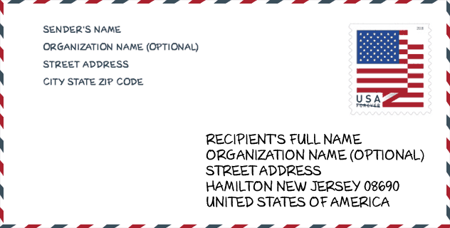
Envelope Example

This is an example of a US zip envelope. You can use a 5-digit zipcode or a detailed 9-digit zipcode to copy the mail in the following address format.
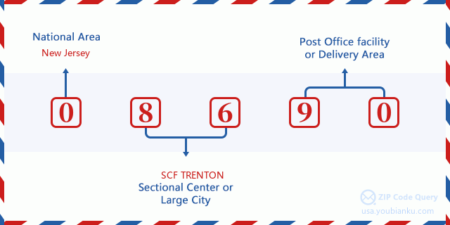
08690 Basic Meaning
What does each digit of ZIP Code 08690 stands for? The first digit designates a national area, which ranges from zero for the Northeast to nine for the far West. The 2-3 digits are the code of a sectional center facility in that region. The last two digits designate small post offices or postal zones.
Online Map

This is online map of the address Trenton, New Jersey, United States. You may use button to move and zoom in / out. The map information is for reference only.
Hospital

This is the ZIP Code 08690 - Hospital page list. Its detail Hospital Name, Street, City, State, ZIP Code, Phone is as below.
- Name: ROBERT WOOD JOHNSON UNIVERSITY HOSPITAL AT HAMILTON
- Address: HAMILTON
- City: ONE HAMILTON HEALTH PLACE
- State: NJ
- ZIP Code: 08690
- Phone: (609) 586-7900
School

This is the ZIP Code 08690 - School page list. Its detail School Name, Address, City, State, ZIP Code is as below.
| School Name | Address | City | State | Grades | ZIP Code |
|---|---|---|---|---|---|
| Hamilton East - Steinert | 2900 KLOCKNER ROAD | HAMILTON | NJ | UG | 08690 |
| Emily C. Reynolds Middle School | 2145 YARDVILLE HAMILTON SQ | HAMILTON | NJ | UG | 08690 |
| University Heights Elementary School | 645 PAXSON AVENUE | HAMILTON | NJ | UG | 08690 |
| Mercer County Technical School Health Sciences Academy | 1085 Old Trenton Road | Trenton | NJ | UG | 08690 |
| Joseph F. Cappello School | 1072 Old Trenton Road | Hamilton | NJ | UG | 08690 |
| Mercer Elementary School | 1020 Old Trenton Road | Hamilton | NJ | UG | 08690 |
Population for ZIP Code 08690

What is the total population in ZIP Code 08690? Below is detail information.
- Population for ZIP Code 08690: 20,010
- 2010 Population: 18,567
The 2020 demographic statistics are in progress. The current population in ZIP code 08690 is 20,010, and the population in 2010 is 18,567.
Gender

In all the statistical population, the male population is 8,805, the female population is 9,762.
- Male Population: 8,805
- Female Population: 9,762
Race

In all the statistical population, the male population is 8,805, the female population is 9,762.
- White Population: 17,172
- Black Population: 494
- Hispanic Population: 705
- Asian Population: 894
- Hawaiian Population: 12
- Indian Population: 57
- Other Population: 170
Age

In all the statistical population, the White population is 17,172, the Black population is 494, the Hispanic population is 705, the Asian population is 894, the Hawaiian population is 12, the Indian Ppopulation is 57 and Other population is 170.
- Age's Median: 45.4
- Median of male age: 43.6
- Median of female age: 46.9
Households for ZIP Code 08690
ZIP code 08690 has 7,178 households, with an average number of 2.57 persons per household. The average income per household in Zip code 08690 is 99,809 USD, and the average house value is 282,800 USD.
- Households Per Zipcode: 7,178
- Persons Per Household: 2.57
- Average House Value: 282,800
- Income Per Household: 99,809
Geographic

The latitude of the Zip code 08690 is 40.233598, the longitude is -74.655096, and the elevation is 99. It has land area of 7.007 square miles, and water area of 0.107 square miles. The time zone for ZIP code 08690 is Eastern (GMT -05:00). Daylight saving time should be observed in the area where the zip code is located.
- Latitude: 40.233598
- Longitude: -74.655096
- Elevation: 99
- Land Area: 7.007
- Water Area: 0.107
- Time Zone: Eastern (GMT -05:00)
- Region: Northeast
- Division: Middle Atlantic
- Day Light Saving: Y
Congressional District

The Congressional District for ZIP code 08690 is New Jersey's 04th|12th congressional district, the Congressional Land Area is 691.88|412.23 square mile.
- Congressional District: 04th|12th
- Congressional Land Area: 691.88|412.23
Delivery

In the ZIP code 08690, there are 7,786 residential delivery mailboxes and centralized units, and 438 commercial delivery mailbox and centralized units, 6,429 single family deliveries and 0 multifamily deliveries, and the box count is 8,347. The main post office has city delivery carrier routes for the ZIP code 08690.
- Delivery Residential: 7,786
- Delivery Business: 438
- Delivery Total: 8,347
- Single Family Delivery Units: 6,429
- Multi Family Delivery Units: 0
- City Delivery Indicator: Y
Business

In ZIP code 08690, the number of business is 462, the number of employee is 8,761, the business first quarter payroll is 93,112,000 USD, the business annual payroll is 357,958,000 USD.
- Number Of Businesses: 462
- Number Of Employees: 8,761
- Business First Quarter Payroll: 93,112,000
- Business Annual Payroll: 357,958,000


Add new comment