ZIP Code: 10472, Bronx, NY
ZIP Code 10472 is located in Bronx, New York. Its detail State, County, City, Longitude, Latitude, Envelope Example, Population is as below.
ZIP Code 10472 Information

-
-
Country:
U.S. - United States
State:
County FIPS:
36005
County:
City:
Area Code:
City Type ?In many cases, a ZIP Code can have multiple "names", meaning cities, towns, or subdivisions, in its boundaries. However, it will ALWAYS have exactly 1 "default" name. D - Default - This is the "preferred" name - by the USPS - for a city. Each ZIP Code has one - and only one - "default" name. In most cases, this is what people who live in that area call the city as well. A - Acceptable - This name can be used for mailing purposes. Often times alternative names are large neighborhoods or sections of the city/town. In some cases a ZIP Code may have several "acceptable" names which is used to group towns under one ZIP Code. N - Not Acceptable - A "not acceptable" name is, in many cases, a nickname that residents give that location. According to the USPS, you should NOT send mail to that ZIP Code using the "not acceptable" name when mailing.:
D (Default)
ZIP Code:
10472
❓What does D (Default) mean? This is the "preferred" name - by the USPS - for a city. Each ZIP Code has one - and only one - "default" name. In most cases, this is what people who live in that area call the city as well.
ZIP Code 10472 Plus 4
ZIP Code 5 plus 4 is the extension of 5-digit zip code, It can be used to locate a more detailed location. The last four digits designate segment or one side of a street or an apartment. You can find the ZIP+4 code and corresponding address of the zip code 10472 below.
| ZIP Code 5 Plus 4 | Address |
|---|---|
| 10472-0001 | PO BOX 1, BRONX, NY |
| 10472-0061 | PO BOX 61, BRONX, NY |
| 10472-0121 | PO BOX 121, BRONX, NY |
| 10472-0181 | PO BOX 181, BRONX, NY |
| 10472-0241 | PO BOX 241, BRONX, NY |
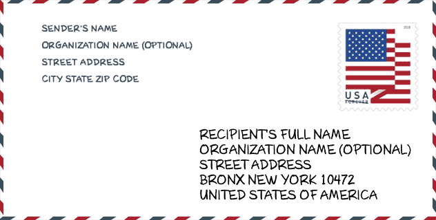
Envelope Example

This is an example of a US zip envelope. You can use a 5-digit zipcode or a detailed 9-digit zipcode to copy the mail in the following address format.
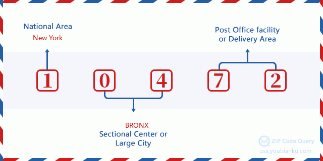
10472 Basic Meaning
What does each digit of ZIP Code 10472 stands for? The first digit designates a national area, which ranges from zero for the Northeast to nine for the far West. The 2-3 digits are the code of a sectional center facility in that region. The last two digits designate small post offices or postal zones.
Online Map

This is online map of the address Bronx, New York, United States. You may use button to move and zoom in / out. The map information is for reference only.
Library

This is the ZIP Code 10472 - Library page list. Its detail Library Name, Address, City, State, ZIP Code, Phone is as below.
- Name: CLASON'S POINT BRANCH
- Address: 1215 MORRISON AVENUE
- City: BRONX
- State: NY - New York
- ZIP Code: 10472
- Phone: (718) 842-1235
School

This is the ZIP Code 10472 - School page list. Its detail School Name, Address, City, State, ZIP Code is as below.
| School Name | Address | City | State | Grades | ZIP Code |
|---|---|---|---|---|---|
| SCHOOL FOR INQUIRY AND SOCIAL JUSTICE (THE) | 1025 MORRISON AVE | BRONX | NY | UG | 10472 |
| BLUEPRINT MIDDLE SCHOOL | 1111 PUGSLEY AVE | BRONX | NY | UG | 10472 |
| PS 583 | 1028 WHITE PLAINS RD | BRONX | NY | UG | 10472 |
| HIGH SCHOOL OF WORLD CULTURES | 1300 BOYNTON AVE | BRONX | NY | UG | 10472 |
| PS 195 | 1250 WARD AVE | BRONX | NY | UG | 10472 |
| PS 196 | 1250 WARD AVE | BRONX | NY | UG | 10472 |
| MOTT HALL V | 1551 E 172ND ST | BRONX | NY | UG | 10472 |
| PAN AMERICAN INTERNATIONAL HIGH SCHOOL AT MONROE | 1300 BOYNTON AVE | BRONX | NY | UG | 10472 |
| CINEMA SCHOOL (THE) | 1551 E 172ND ST | BRONX | NY | UG | 10472 |
| METROPOLITAN SOUNDVIEW HIGH SCHOOL (THE) | 1300 BOYNTON AVE | BRONX | NY | UG | 10472 |
| URBAN ASSEMBLY CHARTER SCHOOL FOR COMPUTER SCIENCE | 1300 BOYNTON AVE-3RD FL | BRONX | NY | UG | 10472 |
| BOLD CHARTER SCHOOL | 1090 CLOSE AVE | BRONX | NY | UG | 10472 |
Population for ZIP Code 10472

What is the total population in ZIP Code 10472? Below is detail information.
- Population for ZIP Code 10472: 58,430
- 2010 Population: 66,358
The 2020 demographic statistics are in progress. The current population in ZIP code 10472 is 58,430, and the population in 2010 is 66,358.
Gender

In all the statistical population, the male population is 31,908, the female population is 34,450.
- Male Population: 31,908
- Female Population: 34,450
Race

In all the statistical population, the male population is 31,908, the female population is 34,450.
- White Population: 18,650
- Black Population: 22,119
- Hispanic Population: 42,887
- Asian Population: 4,784
- Hawaiian Population: 319
- Indian Population: 1,734
- Other Population: 23,010
Age

In all the statistical population, the White population is 18,650, the Black population is 22,119, the Hispanic population is 42,887, the Asian population is 4,784, the Hawaiian population is 319, the Indian Ppopulation is 1,734 and Other population is 23,010.
- Age's Median: 31.1
- Median of male age: 29.4
- Median of female age: 32.7
Households for ZIP Code 10472
ZIP code 10472 has 22,002 households, with an average number of 2.99 persons per household. The average income per household in Zip code 10472 is 30,977 USD, and the average house value is 451,900 USD.
- Households Per Zipcode: 22,002
- Persons Per Household: 2.99
- Average House Value: 451,900
- Income Per Household: 30,977
Geographic

The latitude of the Zip code 10472 is 40.829982, the longitude is -73.865990, and the elevation is 23. It has land area of 1.054 square miles, and water area of 0 square miles. The time zone for ZIP code 10472 is Eastern (GMT -05:00). Daylight saving time should be observed in the area where the zip code is located.
- Latitude: 40.829982
- Longitude: -73.865990
- Elevation: 23
- Land Area: 1.054
- Water Area: 0
- Time Zone: Eastern (GMT -05:00)
- Region: Northeast
- Division: Middle Atlantic
- Day Light Saving: Y
Congressional District

The Congressional District for ZIP code 10472 is New York's 14th|15th congressional district, the Congressional Land Area is 28.29|14.54 square mile.
- Congressional District: 14th|15th
- Congressional Land Area: 28.29|14.54
Delivery

In the ZIP code 10472, there are 19,542 residential delivery mailboxes and centralized units, and 870 commercial delivery mailbox and centralized units, 3,526 single family deliveries and 15,654 multifamily deliveries, and the box count is 21,034. The main post office has city delivery carrier routes for the ZIP code 10472.
- Delivery Residential: 19,542
- Delivery Business: 870
- Delivery Total: 21,034
- Single Family Delivery Units: 3,526
- Multi Family Delivery Units: 15,654
- City Delivery Indicator: Y
Business

In ZIP code 10472, the number of business is 615, the number of employee is 3,958, the business first quarter payroll is 31,265,000 USD, the business annual payroll is 135,576,000 USD.
- Number Of Businesses: 615
- Number Of Employees: 3,958
- Business First Quarter Payroll: 31,265,000
- Business Annual Payroll: 135,576,000
Social Security Benefits

There are 8,615 beneficiaries with benefits in current-payment status for ZIP code 10472, of which 5,180 are retired workers, 1,790 are disabled workers, 510 are widow(er)s and parents, 400 are spouses and 735 are children. The number of beneficiaries aged 65 or older is 5,730. The total monthly benefits are 8,942,000 USD, of which 5,949,000 USD for retired workers, 520,000 USD for widow(er)s and parents.
- Total Number: 8,615
- Retired workers Number: 5,180
- Disabled workers Number: 1,790
- Widow(er)s and parents Number: 510
- Spouses Number: 400
- Children Number: 735
- All beneficiaries per month: 8,942,000
- Retired workers per month: 5,949,000
- Widow(er)s and parents per month: 520,000
- Number of beneficiaries aged 65 or older: 5,730


Add new comment