United States ZIP Code: 10605
This is the New York ZIP Code 10605 page list. Its detail State, County, City, Longitude, Latitude, Envelope Example, Population is as below.
 for ZIP code 10605, highlighting Gedney Farm's rustic allure, featuring famous horse Heatherbloom and French chateau-style Gedney Farm Hotel, set against tree-lined streets and New York state flag.")
ZIP Code 10605 Information

-
-
Country:
U.S. - United States
State:
State FIPS:
36
Area Code:
ZIP Code:
10605
ZIP Type:
S (Standard)
❓What does S (Standard) mean? A "standard" ZIP Code is what most people think of when they talk about ZIP Codes - essentially a town, city, or a division of a city that has mail service.
ZIP Code 10605 - City

This is the city information corresponding to 10605:
| State | County | City | City Type ?In many cases, a ZIP Code can have multiple "names", meaning cities, towns, or subdivisions, in its boundaries. However, it will ALWAYS have exactly 1 "default" name. D - Default - This is the "preferred" name - by the USPS - for a city. Each ZIP Code has one - and only one - "default" name. In most cases, this is what people who live in that area call the city as well. A - Acceptable - This name can be used for mailing purposes. Often times alternative names are large neighborhoods or sections of the city/town. In some cases a ZIP Code may have several "acceptable" names which is used to group towns under one ZIP Code. N - Not Acceptable - A "not acceptable" name is, in many cases, a nickname that residents give that location. According to the USPS, you should NOT send mail to that ZIP Code using the "not acceptable" name when mailing. | ZIP Code |
|---|---|---|---|---|
| NY | Westchester | Gedney | N (Not Acceptable) | 10605 |
| NY | Westchester | White Plains | D (Default) | 10605 |
❓What does D (Default) mean? This is the "preferred" name - by the USPS - for a city. Each ZIP Code has one - and only one - "default" name. In most cases, this is what people who live in that area call the city as well.
❓What does N (Not Acceptable) mean? A "not acceptable" name is, in many cases, a nickname that residents give that location. According to the USPS, you should NOT send mail to that ZIP Code using the "not acceptable" name when mailing.
ZIP Code 10605 Plus 4
ZIP Code 5 plus 4 is the extension of 5-digit zip code, It can be used to locate a more detailed location. The last four digits designate segment or one side of a street or an apartment. You can find the ZIP+4 code and corresponding address of the zip code 10605 below.
| ZIP Code 5 Plus 4 | Address |
|---|---|
| 10605-0001 | PO BOX 1, WHITE PLAINS, NY |
| 10605-0021 | PO BOX 21, WHITE PLAINS, NY |
| 10605-0031 | PO BOX 31, WHITE PLAINS, NY |
| 10605-0051 | PO BOX 51, WHITE PLAINS, NY |
| 10605-0061 | PO BOX 61, WHITE PLAINS, NY |
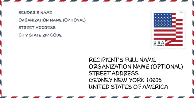
Envelope Example

This is an example of a US zip envelope. You can use a 5-digit zipcode or a detailed 9-digit zipcode to copy the mail in the following address format.
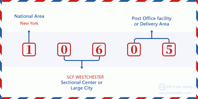
10605 Basic Meaning
What does each digit of ZIP Code 10605 stands for? The first digit designates a national area, which ranges from zero for the Northeast to nine for the far West. The 2-3 digits are the code of a sectional center facility in that region. The last two digits designate small post offices or postal zones.
Online Map

This is online map of the address White Plains, New York, United States. You may use button to move and zoom in / out. The map information is for reference only.
Museum

This is the ZIP Code 10605 - Museum page list. Its detail Museum Name, Street, City, State, ZIP Code, Phone is as below.
- Name: CEDARMERE MUSEUM
- Street: 225 BRYANT AVE
- City: WHITE PLAINS
- State: NY
- ZIP Code: 10605
- Phone: (516) 571-8130
Population for ZIP Code 10605

What is the total population in ZIP Code 10605? Below is detail information.
- Population for ZIP Code 10605: 19,165
- 2010 Population: 18,126
The 2020 demographic statistics are in progress. The current population in ZIP code 10605 is 19,165, and the population in 2010 is 18,126.
Gender

In all the statistical population, the male population is 8,647, the female population is 9,479.
- Male Population: 8,647
- Female Population: 9,479
Race

In all the statistical population, the male population is 8,647, the female population is 9,479.
- White Population: 14,653
- Black Population: 1,626
- Hispanic Population: 2,992
- Asian Population: 1,074
- Hawaiian Population: 72
- Indian Population: 155
- Other Population: 1,075
Age

In all the statistical population, the White population is 14,653, the Black population is 1,626, the Hispanic population is 2,992, the Asian population is 1,074, the Hawaiian population is 72, the Indian Ppopulation is 155 and Other population is 1,075.
- Age's Median: 43.8
- Median of male age: 41.8
- Median of female age: 45.8
Households for ZIP Code 10605
ZIP code 10605 has 7,157 households, with an average number of 2.46 persons per household. The average income per household in Zip code 10605 is 111,399 USD, and the average house value is 637,200 USD.
- Households Per Zipcode: 7,157
- Persons Per Household: 2.46
- Average House Value: 637,200
- Income Per Household: 111,399
Geographic

The latitude of the Zip code 10605 is 41.007673, the longitude is -73.743984, and the elevation is 250. It has land area of 5.081 square miles, and water area of 0.01 square miles. The time zone for ZIP code 10605 is Eastern (GMT -05:00). Daylight saving time should be observed in the area where the zip code is located.
- Latitude: 41.007673
- Longitude: -73.743984
- Elevation: 250
- Land Area: 5.081
- Water Area: 0.01
- Time Zone: Eastern (GMT -05:00)
- Region: Northeast
- Division: Middle Atlantic
- Day Light Saving: Y
Congressional District

The Congressional District for ZIP code 10605 is New York's 16th|17th congressional district, the Congressional Land Area is 78.37|382.63 square mile.
- Congressional District: 16th|17th
- Congressional Land Area: 78.37|382.63
Delivery

In the ZIP code 10605, there are 7,791 residential delivery mailboxes and centralized units, and 461 commercial delivery mailbox and centralized units, 4,823 single family deliveries and 2,500 multifamily deliveries, and the box count is 8,507. The main post office has city delivery carrier routes for the ZIP code 10605.
- Delivery Residential: 7,791
- Delivery Business: 461
- Delivery Total: 8,507
- Single Family Delivery Units: 4,823
- Multi Family Delivery Units: 2,500
- City Delivery Indicator: Y
Business

In ZIP code 10605, the number of business is 690, the number of employee is 9,139, the business first quarter payroll is 125,646,000 USD, the business annual payroll is 519,832,000 USD.
- Number Of Businesses: 690
- Number Of Employees: 9,139
- Business First Quarter Payroll: 125,646,000
- Business Annual Payroll: 519,832,000
Social Security Benefits

There are 4,255 beneficiaries with benefits in current-payment status for ZIP code 10605, of which 3,510 are retired workers, 210 are disabled workers, 215 are widow(er)s and parents, 230 are spouses and 90 are children. The number of beneficiaries aged 65 or older is 3,860. The total monthly benefits are 8,031,000 USD, of which 6,964,000 USD for retired workers, 395,000 USD for widow(er)s and parents.
- Total Number: 4,255
- Retired workers Number: 3,510
- Disabled workers Number: 210
- Widow(er)s and parents Number: 215
- Spouses Number: 230
- Children Number: 90
- All beneficiaries per month: 8,031,000
- Retired workers per month: 6,964,000
- Widow(er)s and parents per month: 395,000
- Number of beneficiaries aged 65 or older: 3,860


Add new comment