ZIP Code: 27545, Knightdale, NC
ZIP Code 27545 is located in Knightdale, North Carolina. Its detail State, County, City, Longitude, Latitude, Envelope Example, Population is as below.
ZIP Code 27545 Information

-
-
Country:
U.S. - United States
State:
County FIPS:
37183
County:
City:
Area Code:
City Type ?In many cases, a ZIP Code can have multiple "names", meaning cities, towns, or subdivisions, in its boundaries. However, it will ALWAYS have exactly 1 "default" name. D - Default - This is the "preferred" name - by the USPS - for a city. Each ZIP Code has one - and only one - "default" name. In most cases, this is what people who live in that area call the city as well. A - Acceptable - This name can be used for mailing purposes. Often times alternative names are large neighborhoods or sections of the city/town. In some cases a ZIP Code may have several "acceptable" names which is used to group towns under one ZIP Code. N - Not Acceptable - A "not acceptable" name is, in many cases, a nickname that residents give that location. According to the USPS, you should NOT send mail to that ZIP Code using the "not acceptable" name when mailing.:
D (Default)
ZIP Code:
27545
❓What does D (Default) mean? This is the "preferred" name - by the USPS - for a city. Each ZIP Code has one - and only one - "default" name. In most cases, this is what people who live in that area call the city as well.
ZIP Code 27545 Plus 4
ZIP Code 5 plus 4 is the extension of 5-digit zip code, It can be used to locate a more detailed location. The last four digits designate segment or one side of a street or an apartment. You can find the ZIP+4 code and corresponding address of the zip code 27545 below.
| ZIP Code 5 Plus 4 | Address |
|---|---|
| 27545-0001 | PO BOX 1, KNIGHTDALE, NC |
| 27545-0121 | PO BOX 121, KNIGHTDALE, NC |
| 27545-0241 | PO BOX 241, KNIGHTDALE, NC |
| 27545-0361 | PO BOX 361, KNIGHTDALE, NC |
| 27545-0421 | PO BOX 421, KNIGHTDALE, NC |
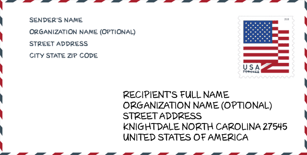
Envelope Example

This is an example of a US zip envelope. You can use a 5-digit zipcode or a detailed 9-digit zipcode to copy the mail in the following address format.
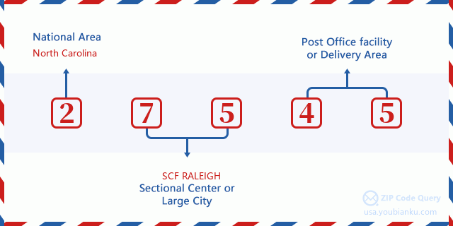
27545 Basic Meaning
What does each digit of ZIP Code 27545 stands for? The first digit designates a national area, which ranges from zero for the Northeast to nine for the far West. The 2-3 digits are the code of a sectional center facility in that region. The last two digits designate small post offices or postal zones.
Online Map

This is online map of the address Knightdale, North Carolina, United States. You may use button to move and zoom in / out. The map information is for reference only.
Library

This is the ZIP Code 27545 - Library page list. Its detail Library Name, Address, City, State, ZIP Code, Phone is as below.
- Name: EAST REGIONAL LIBRARY
- Address: 946 STEEPLE SQUARE CT
- City: KNIGHTDALE
- State: NC - North Carolina
- ZIP Code: 27545
- Phone: (919) 217-5300
School

This is the ZIP Code 27545 - School page list. Its detail School Name, Address, City, State, ZIP Code is as below.
| School Name | Address | City | State | Grades | ZIP Code |
|---|---|---|---|---|---|
| Hodge Road Elementary | 2128 Mingo Bluff Boulevard | Knightdale | NC | UG | 27545 |
| Knightdale Elementary | 109 Ridge St | Knightdale | NC | UG | 27545 |
| Lockhart Elementary | 1320 N Smithfield Rd | Knightdale | NC | UG | 27545 |
| Forestville Road Elementary | 100 Lawson Ridge Road | Knightdale | NC | UG | 27545 |
| Knightdale High | 100 Bryan Chalk Lane | Knightdale | NC | UG | 27545 |
Population for ZIP Code 27545

What is the total population in ZIP Code 27545? Below is detail information.
- Population for ZIP Code 27545: 33,951
- 2010 Population: 23,006
The 2020 demographic statistics are in progress. The current population in ZIP code 27545 is 33,951, and the population in 2010 is 23,006.
Gender

In all the statistical population, the male population is 11,020, the female population is 11,986.
- Male Population: 11,020
- Female Population: 11,986
Race

In all the statistical population, the male population is 11,020, the female population is 11,986.
- White Population: 12,236
- Black Population: 8,473
- Hispanic Population: 3,730
- Asian Population: 526
- Hawaiian Population: 27
- Indian Population: 432
- Other Population: 2,235
Age

In all the statistical population, the White population is 12,236, the Black population is 8,473, the Hispanic population is 3,730, the Asian population is 526, the Hawaiian population is 27, the Indian Ppopulation is 432 and Other population is 2,235.
- Age's Median: 33.4
- Median of male age: 32.4
- Median of female age: 34.4
Households for ZIP Code 27545
ZIP code 27545 has 8,356 households, with an average number of 2.74 persons per household. The average income per household in Zip code 27545 is 63,683 USD, and the average house value is 168,600 USD.
- Households Per Zipcode: 8,356
- Persons Per Household: 2.74
- Average House Value: 168,600
- Income Per Household: 63,683
Housing Unit

In ZIP code 27545, the growth rank of housing unit is 49, the number of housing unit was 900,993 in 2010 and increased to 929,780 in 2011, the growth increase number is 28,787, the growth increase percentage is 3.2%.
- Growth Rank: 49
- Housing Units Estimate in 2010: 900,993
- Housing Units Estimate in 2011: 929,780
- Growth Increase Number: 28,787
- Growth Increase Percentage: 3.2%
Geographic

The latitude of the Zip code 27545 is 35.791996, the longitude is -78.475758, and the elevation is 323. It has land area of 28.993 square miles, and water area of 0.083 square miles. The time zone for ZIP code 27545 is Eastern (GMT -05:00). Daylight saving time should be observed in the area where the zip code is located.
- Latitude: 35.791996
- Longitude: -78.475758
- Elevation: 323
- Land Area: 28.993
- Water Area: 0.083
- Time Zone: Eastern (GMT -05:00)
- Region: South
- Division: South Atlantic
- Day Light Saving: Y
Congressional District

The Congressional District for ZIP code 27545 is North Carolina's 2nd|04th congressional district, the Congressional Land Area is 3246.68|1045.35 square mile.
- Congressional District: 2nd|04th
- Congressional Land Area: 3246.68|1045.35
Delivery

In the ZIP code 27545, there are 12,391 residential delivery mailboxes and centralized units, and 485 commercial delivery mailbox and centralized units, 8,277 single family deliveries and 2,419 multifamily deliveries, and the box count is 13,700. The main post office does not have city delivery carrier routes for the ZIP code 27545.
- Delivery Residential: 12,391
- Delivery Business: 485
- Delivery Total: 13,700
- Single Family Delivery Units: 8,277
- Multi Family Delivery Units: 2,419
- City Delivery Indicator: N
Business

In ZIP code 27545, the number of business is 503, the number of employee is 6,475, the business first quarter payroll is 54,799,000 USD, the business annual payroll is 228,471,000 USD.
- Number Of Businesses: 503
- Number Of Employees: 6,475
- Business First Quarter Payroll: 54,799,000
- Business Annual Payroll: 228,471,000
Social Security Benefits

There are 4,110 beneficiaries with benefits in current-payment status for ZIP code 27545, of which 2,805 are retired workers, 685 are disabled workers, 190 are widow(er)s and parents, 80 are spouses and 350 are children. The number of beneficiaries aged 65 or older is 2,835. The total monthly benefits are 5,898,000 USD, of which 4,387,000 USD for retired workers, 254,000 USD for widow(er)s and parents.
- Total Number: 4,110
- Retired workers Number: 2,805
- Disabled workers Number: 685
- Widow(er)s and parents Number: 190
- Spouses Number: 80
- Children Number: 350
- All beneficiaries per month: 5,898,000
- Retired workers per month: 4,387,000
- Widow(er)s and parents per month: 254,000
- Number of beneficiaries aged 65 or older: 2,835


Add new comment