United States ZIP Code: 27609
This is the North Carolina ZIP Code 27609 page list. Its detail State, County, City, Longitude, Latitude, Envelope Example, Population is as below.
ZIP Code 27609 Information

-
-
Country:
U.S. - United States
State:
State FIPS:
37
ZIP Code:
27609
ZIP Type:
S (Standard)
❓What does S (Standard) mean? A "standard" ZIP Code is what most people think of when they talk about ZIP Codes - essentially a town, city, or a division of a city that has mail service.
ZIP Code 27609 - City

This is the city information corresponding to 27609:
| State | County | City | City Type ?In many cases, a ZIP Code can have multiple "names", meaning cities, towns, or subdivisions, in its boundaries. However, it will ALWAYS have exactly 1 "default" name. D - Default - This is the "preferred" name - by the USPS - for a city. Each ZIP Code has one - and only one - "default" name. In most cases, this is what people who live in that area call the city as well. A - Acceptable - This name can be used for mailing purposes. Often times alternative names are large neighborhoods or sections of the city/town. In some cases a ZIP Code may have several "acceptable" names which is used to group towns under one ZIP Code. N - Not Acceptable - A "not acceptable" name is, in many cases, a nickname that residents give that location. According to the USPS, you should NOT send mail to that ZIP Code using the "not acceptable" name when mailing. | ZIP Code |
|---|---|---|---|---|
| NC | Wake | North Hills | N (Not Acceptable) | 27609 |
| NC | Wake | Raleigh | D (Default) | 27609 |
❓What does D (Default) mean? This is the "preferred" name - by the USPS - for a city. Each ZIP Code has one - and only one - "default" name. In most cases, this is what people who live in that area call the city as well.
❓What does N (Not Acceptable) mean? A "not acceptable" name is, in many cases, a nickname that residents give that location. According to the USPS, you should NOT send mail to that ZIP Code using the "not acceptable" name when mailing.
ZIP Code 27609 Plus 4
ZIP Code 5 plus 4 is the extension of 5-digit zip code, It can be used to locate a more detailed location. The last four digits designate segment or one side of a street or an apartment. You can find the ZIP+4 code and corresponding address of the zip code 27609 below.
| ZIP Code 5 Plus 4 | Address |
|---|---|
| 27609-0400 | 10101 MEARRALT DR, RALEIGH, NC |
| 27609-1100 | 2511 CEDAR FOREST WAY #00000036 , RALEIGH, NC |
| 27609-1100 | 2511 CEDAR FOREST WAY #00000101 , RALEIGH, NC |
| 27609-1101 | 2521 CEDAR FOREST WAY #00000101 , RALEIGH, NC |
| 27609-1102 | 2540 CEDAR FOREST WAY #00000101 , RALEIGH, NC |
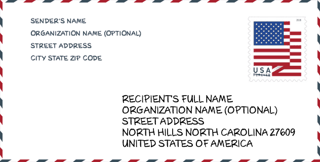
Envelope Example

This is an example of a US zip envelope. You can use a 5-digit zipcode or a detailed 9-digit zipcode to copy the mail in the following address format.
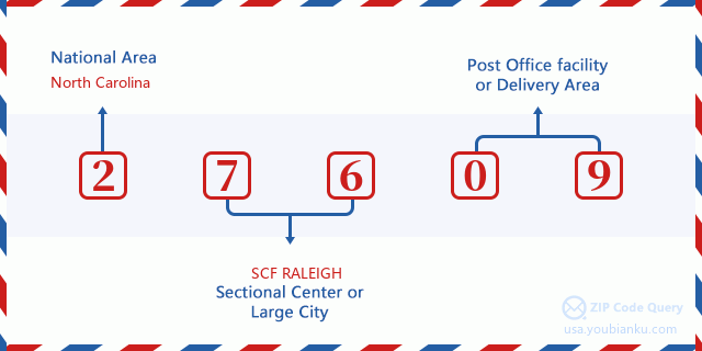
27609 Basic Meaning
What does each digit of ZIP Code 27609 stands for? The first digit designates a national area, which ranges from zero for the Northeast to nine for the far West. The 2-3 digits are the code of a sectional center facility in that region. The last two digits designate small post offices or postal zones.
Online Map

This is online map of the address Raleigh, North Carolina, United States. You may use button to move and zoom in / out. The map information is for reference only.
Hospital

This is the ZIP Code 27609 - Hospital page list. Its detail Hospital Name, Street, City, State, ZIP Code, Phone is as below.
- Name: DUKE HEALTH RALEIGH HOSPITAL
- Address: RALEIGH
- City: 3400 WAKE FOREST RD
- State: NC
- ZIP Code: 27609
- Phone: (919) 954-3000
School

This is the ZIP Code 27609 - School page list. Its detail School Name, Address, City, State, ZIP Code is as below.
- School Name: Green Elementary
- Address: 5307 Six Forks Road
- City: Raleigh
- State: NC
- Grades: UG
- ZIP Code: 27609
Population for ZIP Code 27609

What is the total population in ZIP Code 27609? Below is detail information.
- Population for ZIP Code 27609: 38,810
- 2010 Population: 32,964
The 2020 demographic statistics are in progress. The current population in ZIP code 27609 is 38,810, and the population in 2010 is 32,964.
Gender

In all the statistical population, the male population is 15,699, the female population is 17,265.
- Male Population: 15,699
- Female Population: 17,265
Race

In all the statistical population, the male population is 15,699, the female population is 17,265.
- White Population: 23,614
- Black Population: 6,702
- Hispanic Population: 4,205
- Asian Population: 813
- Hawaiian Population: 62
- Indian Population: 323
- Other Population: 2,385
Age

In all the statistical population, the White population is 23,614, the Black population is 6,702, the Hispanic population is 4,205, the Asian population is 813, the Hawaiian population is 62, the Indian Ppopulation is 323 and Other population is 2,385.
- Age's Median: 37.4
- Median of male age: 35.8
- Median of female age: 38.9
Households for ZIP Code 27609
ZIP code 27609 has 15,106 households, with an average number of 2.18 persons per household. The average income per household in Zip code 27609 is 58,983 USD, and the average house value is 289,500 USD.
- Households Per Zipcode: 15,106
- Persons Per Household: 2.18
- Average House Value: 289,500
- Income Per Household: 58,983
Housing Unit

In ZIP code 27609, the growth rank of housing unit is 49, the number of housing unit was 900,993 in 2010 and increased to 929,780 in 2011, the growth increase number is 28,787, the growth increase percentage is 3.2%.
- Growth Rank: 49
- Housing Units Estimate in 2010: 900,993
- Housing Units Estimate in 2011: 929,780
- Growth Increase Number: 28,787
- Growth Increase Percentage: 3.2%
Geographic

The latitude of the Zip code 27609 is 35.842711, the longitude is -78.631850, and the elevation is 318. It has land area of 11.173 square miles, and water area of 0.046 square miles. The time zone for ZIP code 27609 is Eastern (GMT -05:00). Daylight saving time should be observed in the area where the zip code is located.
- Latitude: 35.842711
- Longitude: -78.631850
- Elevation: 318
- Land Area: 11.173
- Water Area: 0.046
- Time Zone: Eastern (GMT -05:00)
- Region: South
- Division: South Atlantic
- Day Light Saving: Y
Congressional District

The Congressional District for ZIP code 27609 is North Carolina's 04th congressional district, the Congressional Land Area is 1045.35 square mile.
- Congressional District: 04th
- Congressional Land Area: 1045.35
Delivery

In the ZIP code 27609, there are 17,803 residential delivery mailboxes and centralized units, and 2,114 commercial delivery mailbox and centralized units, 8,709 single family deliveries and 5,809 multifamily deliveries, and the box count is 19,972. The main post office has city delivery carrier routes for the ZIP code 27609.
- Delivery Residential: 17,803
- Delivery Business: 2,114
- Delivery Total: 19,972
- Single Family Delivery Units: 8,709
- Multi Family Delivery Units: 5,809
- City Delivery Indicator: Y
Business

In ZIP code 27609, the number of business is 1,911, the number of employee is 30,286, the business first quarter payroll is 437,275,000 USD, the business annual payroll is 1,742,541,000 USD.
- Number Of Businesses: 1,911
- Number Of Employees: 30,286
- Business First Quarter Payroll: 437,275,000
- Business Annual Payroll: 1,742,541,000
Social Security Benefits

There are 6,290 beneficiaries with benefits in current-payment status for ZIP code 27609, of which 4,775 are retired workers, 495 are disabled workers, 355 are widow(er)s and parents, 255 are spouses and 410 are children. The number of beneficiaries aged 65 or older is 5,235. The total monthly benefits are 10,219,000 USD, of which 8,356,000 USD for retired workers, 592,000 USD for widow(er)s and parents.
- Total Number: 6,290
- Retired workers Number: 4,775
- Disabled workers Number: 495
- Widow(er)s and parents Number: 355
- Spouses Number: 255
- Children Number: 410
- All beneficiaries per month: 10,219,000
- Retired workers per month: 8,356,000
- Widow(er)s and parents per month: 592,000
- Number of beneficiaries aged 65 or older: 5,235


Add new comment