ZIP Code: 28215, Charlotte, NC
ZIP Code 28215 is located in Charlotte, North Carolina. Its detail State, County, City, Longitude, Latitude, Envelope Example, Population is as below.
ZIP Code 28215 Information

-
-
Country:
U.S. - United States
State:
County FIPS:
37119
City:
Area Code:
City Type ?In many cases, a ZIP Code can have multiple "names", meaning cities, towns, or subdivisions, in its boundaries. However, it will ALWAYS have exactly 1 "default" name. D - Default - This is the "preferred" name - by the USPS - for a city. Each ZIP Code has one - and only one - "default" name. In most cases, this is what people who live in that area call the city as well. A - Acceptable - This name can be used for mailing purposes. Often times alternative names are large neighborhoods or sections of the city/town. In some cases a ZIP Code may have several "acceptable" names which is used to group towns under one ZIP Code. N - Not Acceptable - A "not acceptable" name is, in many cases, a nickname that residents give that location. According to the USPS, you should NOT send mail to that ZIP Code using the "not acceptable" name when mailing.:
D (Default)
ZIP Code:
28215
❓What does D (Default) mean? This is the "preferred" name - by the USPS - for a city. Each ZIP Code has one - and only one - "default" name. In most cases, this is what people who live in that area call the city as well.
-


-
Iconic US Landmark Legacy Designs
Get PNG, SVG, EPS, AI, PDF Versions at Just $0.1
 Download Now
-


ZipCodeCraft
ZIP Code 28215 Plus 4
ZIP Code 5 plus 4 is the extension of 5-digit zip code, It can be used to locate a more detailed location. The last four digits designate segment or one side of a street or an apartment. You can find the ZIP+4 code and corresponding address of the zip code 28215 below.
| ZIP Code 5 Plus 4 | Address |
|---|---|
| 28215-0001 | PO BOX 42001, CHARLOTTE, NC |
| 28215-0002 | PO BOX 42100, CHARLOTTE, NC |
| 28215-0003 | PO BOX 42121, CHARLOTTE, NC |
| 28215-0004 | PO BOX 42201, CHARLOTTE, NC |
| 28215-0005 | PO BOX 42241, CHARLOTTE, NC |
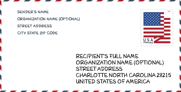
Envelope Example

This is an example of a US zip envelope. You can use a 5-digit zipcode or a detailed 9-digit zipcode to copy the mail in the following address format.
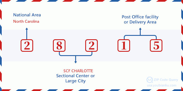
28215 Basic Meaning
What does each digit of ZIP Code 28215 stands for? The first digit designates a national area, which ranges from zero for the Northeast to nine for the far West. The 2-3 digits are the code of a sectional center facility in that region. The last two digits designate small post offices or postal zones.
Online Map

This is online map of the address Charlotte, North Carolina, United States. You may use button to move and zoom in / out. The map information is for reference only.
Hospital

This is the ZIP Code 28215 - Hospital page list. Its detail Hospital Name, Street, City, State, ZIP Code, Phone is as below.
- Name: NOVANT HEALTH MINT HILL MEDICAL CENTER
- Address: CHARLOTTE
- City: 8201 HEALTHCARE LOOP
- State: NC
- ZIP Code: 28215
- Phone: (704) 384-4089
Library

This is the ZIP Code 28215 - Library page list. Its detail Library Name, Address, City, State, ZIP Code, Phone is as below.
- Name: HICKORY GROVE BRANCH LIBRARY
- Address: 5935 HICKORY GROVE RD
- City: CHARLOTTE
- State: NC - North Carolina
- ZIP Code: 28215
- Phone: (704) 416-4400
School

This is the ZIP Code 28215 - School page list. Its detail School Name, Address, City, State, ZIP Code is as below.
| School Name | Address | City | State | Grades | ZIP Code |
|---|---|---|---|---|---|
| KIPP Charlotte | 931 Wilann Dr | Charlotte | NC | UG | 28215 |
| Eastside STREAM Academy | 3124 Milton Road | Charlotte | NC | UG | 28215 |
Population for ZIP Code 28215

What is the total population in ZIP Code 28215? Below is detail information.
- Population for ZIP Code 28215: 63,810
- 2010 Population: 53,629
The 2020 demographic statistics are in progress. The current population in ZIP code 28215 is 63,810, and the population in 2010 is 53,629.
Gender

In all the statistical population, the male population is 25,458, the female population is 28,171.
- Male Population: 25,458
- Female Population: 28,171
Race

In all the statistical population, the male population is 25,458, the female population is 28,171.
- White Population: 18,628
- Black Population: 28,182
- Hispanic Population: 9,700
- Asian Population: 1,854
- Hawaiian Population: 133
- Indian Population: 792
- Other Population: 6,061
Age

In all the statistical population, the White population is 18,628, the Black population is 28,182, the Hispanic population is 9,700, the Asian population is 1,854, the Hawaiian population is 133, the Indian Ppopulation is 792 and Other population is 6,061.
- Age's Median: 33.2
- Median of male age: 31.2
- Median of female age: 34.8
Households for ZIP Code 28215
ZIP code 28215 has 19,074 households, with an average number of 2.79 persons per household. The average income per household in Zip code 28215 is 50,305 USD, and the average house value is 146,600 USD.
- Households Per Zipcode: 19,074
- Persons Per Household: 2.79
- Average House Value: 146,600
- Income Per Household: 50,305
Housing Unit

In ZIP code 28215, the growth rank of housing unit is 77, the number of housing unit was 919,628 in 2010 and increased to 944,373 in 2011, the growth increase number is 24,745, the growth increase percentage is 2.7%.
- Growth Rank: 77
- Housing Units Estimate in 2010: 919,628
- Housing Units Estimate in 2011: 944,373
- Growth Increase Number: 24,745
- Growth Increase Percentage: 2.7%
Geographic

The latitude of the Zip code 28215 is 35.251976, the longitude is -80.697133, and the elevation is 640. It has land area of 30.553 square miles, and water area of 0.203 square miles. The time zone for ZIP code 28215 is Eastern (GMT -05:00). Daylight saving time should be observed in the area where the zip code is located.
- Latitude: 35.251976
- Longitude: -80.697133
- Elevation: 640
- Land Area: 30.553
- Water Area: 0.203
- Time Zone: Eastern (GMT -05:00)
- Region: South
- Division: South Atlantic
- Day Light Saving: Y
Congressional District

The Congressional District for ZIP code 28215 is North Carolina's 08th|12th congressional district, the Congressional Land Area is 4512.78|549.66 square mile.
- Congressional District: 08th|12th
- Congressional Land Area: 4512.78|549.66
Delivery

In the ZIP code 28215, there are 22,871 residential delivery mailboxes and centralized units, and 551 commercial delivery mailbox and centralized units, 16,411 single family deliveries and 3,563 multifamily deliveries, and the box count is 25,761. The main post office has city delivery carrier routes for the ZIP code 28215.
- Delivery Residential: 22,871
- Delivery Business: 551
- Delivery Total: 25,761
- Single Family Delivery Units: 16,411
- Multi Family Delivery Units: 3,563
- City Delivery Indicator: Y
Business

In ZIP code 28215, the number of business is 574, the number of employee is 5,282, the business first quarter payroll is 41,260,000 USD, the business annual payroll is 171,463,000 USD.
- Number Of Businesses: 574
- Number Of Employees: 5,282
- Business First Quarter Payroll: 41,260,000
- Business Annual Payroll: 171,463,000
Social Security Benefits

There are 8,980 beneficiaries with benefits in current-payment status for ZIP code 28215, of which 6,185 are retired workers, 1,410 are disabled workers, 445 are widow(er)s and parents, 200 are spouses and 740 are children. The number of beneficiaries aged 65 or older is 6,355. The total monthly benefits are 12,047,000 USD, of which 9,160,000 USD for retired workers, 577,000 USD for widow(er)s and parents.
- Total Number: 8,980
- Retired workers Number: 6,185
- Disabled workers Number: 1,410
- Widow(er)s and parents Number: 445
- Spouses Number: 200
- Children Number: 740
- All beneficiaries per month: 12,047,000
- Retired workers per month: 9,160,000
- Widow(er)s and parents per month: 577,000
- Number of beneficiaries aged 65 or older: 6,355


Add new comment