ZIP Code: 28501, Kinston, NC
ZIP Code 28501 is located in Kinston, North Carolina. Its detail State, County, City, Longitude, Latitude, Envelope Example, Population is as below.
ZIP Code 28501 Information

-
-
Country:
U.S. - United States
State:
County FIPS:
37107
County:
City:
Area Code:
City Type ?In many cases, a ZIP Code can have multiple "names", meaning cities, towns, or subdivisions, in its boundaries. However, it will ALWAYS have exactly 1 "default" name. D - Default - This is the "preferred" name - by the USPS - for a city. Each ZIP Code has one - and only one - "default" name. In most cases, this is what people who live in that area call the city as well. A - Acceptable - This name can be used for mailing purposes. Often times alternative names are large neighborhoods or sections of the city/town. In some cases a ZIP Code may have several "acceptable" names which is used to group towns under one ZIP Code. N - Not Acceptable - A "not acceptable" name is, in many cases, a nickname that residents give that location. According to the USPS, you should NOT send mail to that ZIP Code using the "not acceptable" name when mailing.:
D (Default)
ZIP Code:
28501
❓What does D (Default) mean? This is the "preferred" name - by the USPS - for a city. Each ZIP Code has one - and only one - "default" name. In most cases, this is what people who live in that area call the city as well.
ZIP Code 28501 Plus 4
ZIP Code 5 plus 4 is the extension of 5-digit zip code, It can be used to locate a more detailed location. The last four digits designate segment or one side of a street or an apartment. You can find the ZIP+4 code and corresponding address of the zip code 28501 below.
| ZIP Code 5 Plus 4 | Address |
|---|---|
| 28501-0001 | PO BOX 6001, KINSTON, NC |
| 28501-0121 | PO BOX 6121, KINSTON, NC |
| 28501-0241 | PO BOX 6241, KINSTON, NC |
| 28501-0301 | PO BOX 6301, KINSTON, NC |
| 28501-0421 | PO BOX 6421, KINSTON, NC |
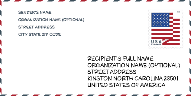
Envelope Example

This is an example of a US zip envelope. You can use a 5-digit zipcode or a detailed 9-digit zipcode to copy the mail in the following address format.
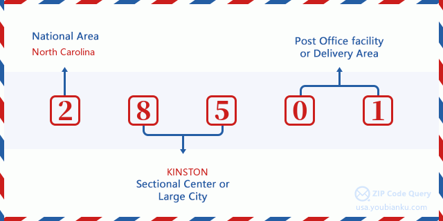
28501 Basic Meaning
What does each digit of ZIP Code 28501 stands for? The first digit designates a national area, which ranges from zero for the Northeast to nine for the far West. The 2-3 digits are the code of a sectional center facility in that region. The last two digits designate small post offices or postal zones.
Online Map

This is online map of the address Kinston, North Carolina, United States. You may use button to move and zoom in / out. The map information is for reference only.
Hospital

This is the ZIP Code 28501 - Hospital page list. Its detail Hospital Name, Street, City, State, ZIP Code, Phone is as below.
- Name: UNC LENOIR HEALTH CARE
- Address: KINSTON
- City: 100 AIRPORT RD
- State: NC
- ZIP Code: 28501
- Phone: (252) 522-7000
Museum

This is the ZIP Code 28501 - Museum page list. Its detail Museum Name, Street, City, State, ZIP Code, Phone is as below.
| Name | Street | City | State | ZIP Code | Phone |
| CASWELL NO. 1 FIRE STATION MUSEUM | 118 S QUEEN ST | KINSTON | NC | 28501 | (252) 527-1566 |
| NEUSEWAY PLANETARIUM | 401 W CASWELL STREET | KINSTON | NC | 28501 |
Library

This is the ZIP Code 28501 - Library page list. Its detail Library Name, Address, City, State, ZIP Code, Phone is as below.
| Name | Address | City | State | ZIP Code | Phone |
|---|---|---|---|---|---|
| KINSTON-LENOIR COUNTY PUBLIC LIBRARY | 510 N QUEEN ST | KINSTON | NC | 28501 | (252) 527-7066 |
| NEUSE REGIONAL LIBRARY | 510 N QUEEN ST | KINSTON | NC | 28501 | (252) 527-7066 |
School

This is the ZIP Code 28501 - School page list. Its detail School Name, Address, City, State, ZIP Code is as below.
| School Name | Address | City | State | Grades | ZIP Code |
|---|---|---|---|---|---|
| Children's Village Academy | 701 North Adkin Street | Kinston | NC | UG | 28501 |
| Southeast Elementary | 201 McDaniels Street | Kinston | NC | UG | 28501 |
| Contentnea-Savannah School | 3400 Ferrell Road | Kinston | NC | UG | 28501 |
Population for ZIP Code 28501

What is the total population in ZIP Code 28501? Below is detail information.
- Population for ZIP Code 28501: 19,290
- 2010 Population: 20,389
The 2020 demographic statistics are in progress. The current population in ZIP code 28501 is 19,290, and the population in 2010 is 20,389.
Gender

In all the statistical population, the male population is 9,354, the female population is 11,035.
- Male Population: 9,354
- Female Population: 11,035
Race

In all the statistical population, the male population is 9,354, the female population is 11,035.
- White Population: 6,509
- Black Population: 13,486
- Hispanic Population: 692
- Asian Population: 142
- Hawaiian Population: 19
- Indian Population: 130
- Other Population: 405
Age

In all the statistical population, the White population is 6,509, the Black population is 13,486, the Hispanic population is 692, the Asian population is 142, the Hawaiian population is 19, the Indian Ppopulation is 130 and Other population is 405.
- Age's Median: 40.8
- Median of male age: 37.9
- Median of female age: 43.3
Households for ZIP Code 28501
ZIP code 28501 has 8,696 households, with an average number of 2.29 persons per household. The average income per household in Zip code 28501 is 30,053 USD, and the average house value is 83,900 USD.
- Households Per Zipcode: 8,696
- Persons Per Household: 2.29
- Average House Value: 83,900
- Income Per Household: 30,053
Geographic

The latitude of the Zip code 28501 is 35.264366, the longitude is -77.499001, and the elevation is 33. It has land area of 106.183 square miles, and water area of 0.782 square miles. The time zone for ZIP code 28501 is Eastern (GMT -05:00). Daylight saving time should be observed in the area where the zip code is located.
- Latitude: 35.264366
- Longitude: -77.499001
- Elevation: 33
- Land Area: 106.183
- Water Area: 0.782
- Time Zone: Eastern (GMT -05:00)
- Region: South
- Division: South Atlantic
- Day Light Saving: Y
Congressional District

The Congressional District for ZIP code 28501 is North Carolina's 3rd congressional district, the Congressional Land Area is 7810.08 square mile.
- Congressional District: 3rd
- Congressional Land Area: 7810.08
Delivery

In the ZIP code 28501, there are 8,424 residential delivery mailboxes and centralized units, and 759 commercial delivery mailbox and centralized units, 6,401 single family deliveries and 572 multifamily deliveries, and the box count is 10,227. The main post office has city delivery carrier routes for the ZIP code 28501.
- Delivery Residential: 8,424
- Delivery Business: 759
- Delivery Total: 10,227
- Single Family Delivery Units: 6,401
- Multi Family Delivery Units: 572
- City Delivery Indicator: Y
Business

In ZIP code 28501, the number of business is 488, the number of employee is 8,867, the business first quarter payroll is 74,069,000 USD, the business annual payroll is 315,561,000 USD.
- Number Of Businesses: 488
- Number Of Employees: 8,867
- Business First Quarter Payroll: 74,069,000
- Business Annual Payroll: 315,561,000
Social Security Benefits

There are 4,825 beneficiaries with benefits in current-payment status for ZIP code 28501, of which 3,080 are retired workers, 995 are disabled workers, 285 are widow(er)s and parents, 75 are spouses and 390 are children. The number of beneficiaries aged 65 or older is 3,200. The total monthly benefits are 5,561,000 USD, of which 3,863,000 USD for retired workers, 332,000 USD for widow(er)s and parents.
- Total Number: 4,825
- Retired workers Number: 3,080
- Disabled workers Number: 995
- Widow(er)s and parents Number: 285
- Spouses Number: 75
- Children Number: 390
- All beneficiaries per month: 5,561,000
- Retired workers per month: 3,863,000
- Widow(er)s and parents per month: 332,000
- Number of beneficiaries aged 65 or older: 3,200


Add new comment