United States ZIP Code: 40242
This is the Kentucky ZIP Code 40242 page list. Its detail State, County, City, Longitude, Latitude, Envelope Example, Population is as below.

ZIP Code 40242 Information

-
-
Country:
U.S. - United States
State:
State FIPS:
21
Area Code:
ZIP Code:
40242
ZIP Type:
S (Standard)
❓What does S (Standard) mean? A "standard" ZIP Code is what most people think of when they talk about ZIP Codes - essentially a town, city, or a division of a city that has mail service.
ZIP Code 40242 - City

This is the city information corresponding to 40242:
| State | County | City | City Type ?In many cases, a ZIP Code can have multiple "names", meaning cities, towns, or subdivisions, in its boundaries. However, it will ALWAYS have exactly 1 "default" name. D - Default - This is the "preferred" name - by the USPS - for a city. Each ZIP Code has one - and only one - "default" name. In most cases, this is what people who live in that area call the city as well. A - Acceptable - This name can be used for mailing purposes. Often times alternative names are large neighborhoods or sections of the city/town. In some cases a ZIP Code may have several "acceptable" names which is used to group towns under one ZIP Code. N - Not Acceptable - A "not acceptable" name is, in many cases, a nickname that residents give that location. According to the USPS, you should NOT send mail to that ZIP Code using the "not acceptable" name when mailing. | ZIP Code |
|---|---|---|---|---|
| KY | Jefferson | Briarwood | A (Acceptable) | 40242 |
| KY | Jefferson | Langdon Place | A (Acceptable) | 40242 |
| KY | Jefferson | Louisville | D (Default) | 40242 |
| KY | Jefferson | Lyndon | A (Acceptable) | 40242 |
| KY | Jefferson | Meadow Vale | A (Acceptable) | 40242 |
| KY | Jefferson | Murray Hill | A (Acceptable) | 40242 |
| KY | Jefferson | Old Brownsboro Place | A (Acceptable) | 40242 |
| KY | Jefferson | Old Brownsbro | A (Acceptable) | 40242 |
| KY | Jefferson | Plantation | A (Acceptable) | 40242 |
| KY | Jefferson | Rolling Hills | A (Acceptable) | 40242 |
❓What does D (Default) mean? This is the "preferred" name - by the USPS - for a city. Each ZIP Code has one - and only one - "default" name. In most cases, this is what people who live in that area call the city as well.
❓What does A (Acceptable) mean? This name can be used for mailing purposes. Often times alternative names are large neighborhoods or sections of the city/town. In some cases a ZIP Code may have several "acceptable" names which is used to group towns under one ZIP Code.
ZIP Code 40242 Plus 4
ZIP Code 5 plus 4 is the extension of 5-digit zip code, It can be used to locate a more detailed location. The last four digits designate segment or one side of a street or an apartment. You can find the ZIP+4 code and corresponding address of the zip code 40242 below.
| ZIP Code 5 Plus 4 | Address |
|---|---|
| 40242-2201 | 2801 GOOSE CREEK RD, LOUISVILLE, KY |
| 40242-2202 | 2800 GOOSE CREEK RD, LOUISVILLE, KY |
| 40242-2225 | 2600 AYLESBURY CT, LOUISVILLE, KY |
| 40242-2226 | 9401 AYLESBURY DR, LOUISVILLE, KY |
| 40242-2227 | 9400 AYLESBURY DR, LOUISVILLE, KY |
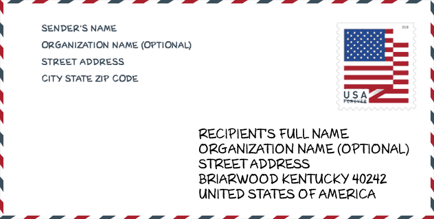
Envelope Example

This is an example of a US zip envelope. You can use a 5-digit zipcode or a detailed 9-digit zipcode to copy the mail in the following address format.
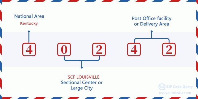
40242 Basic Meaning
What does each digit of ZIP Code 40242 stands for? The first digit designates a national area, which ranges from zero for the Northeast to nine for the far West. The 2-3 digits are the code of a sectional center facility in that region. The last two digits designate small post offices or postal zones.
Online Map

This is online map of the address Rolling Hills, Kentucky, United States. You may use button to move and zoom in / out. The map information is for reference only.
Hospital

This is the ZIP Code 40242 - Hospital page list. Its detail Hospital Name, Street, City, State, ZIP Code, Phone is as below.
- Name: THE BROOK HOSPITAL - KMI
- Address: LOUISVILLE
- City: 8521 LAGRANGE ROAD
- State: KY
- ZIP Code: 40242
- Phone: (502) 426-6380
School

This is the ZIP Code 40242 - School page list. Its detail School Name, Address, City, State, ZIP Code is as below.
| School Name | Address | City | State | Grades | ZIP Code |
|---|---|---|---|---|---|
| Bowen Elementary | 1601 Roosevelt Ave | Louisville | KY | UG | 40242 |
| Louisville Day | 8711 Lagrange Rd | Louisville | KY | UG | 40242 |
| Jefferson Regional Juvenile Detention Ce | 8711 LAGRANGE RD BUILDING D | Louisville | KY | UG | 40242 |
| The Brook-KMI | 8521 LaGrange Rd | Louisville | KY | UG | 40242 |
| Westport Early Childhood Center | 8800 Westport Rd | Louisville | KY | UG | 40242 |
Population for ZIP Code 40242

What is the total population in ZIP Code 40242? Below is detail information.
- Population for ZIP Code 40242: 11,057
- 2010 Population: 10,930
The 2020 demographic statistics are in progress. The current population in ZIP code 40242 is 11,057, and the population in 2010 is 10,930.
Gender

In all the statistical population, the male population is 5,225, the female population is 5,705.
- Male Population: 5,225
- Female Population: 5,705
Race

In all the statistical population, the male population is 5,225, the female population is 5,705.
- White Population: 9,486
- Black Population: 1,074
- Hispanic Population: 522
- Asian Population: 288
- Hawaiian Population: 7
- Indian Population: 84
- Other Population: 258
Age

In all the statistical population, the White population is 9,486, the Black population is 1,074, the Hispanic population is 522, the Asian population is 288, the Hawaiian population is 7, the Indian Ppopulation is 84 and Other population is 258.
- Age's Median: 38.9
- Median of male age: 36.5
- Median of female age: 41.6
Households for ZIP Code 40242
ZIP code 40242 has 4,665 households, with an average number of 2.31 persons per household. The average income per household in Zip code 40242 is 68,004 USD, and the average house value is 195,800 USD.
- Households Per Zipcode: 4,665
- Persons Per Household: 2.31
- Average House Value: 195,800
- Income Per Household: 68,004
Geographic

The latitude of the Zip code 40242 is 38.278201, the longitude is -85.593992, and the elevation is 622. It has land area of 2.667 square miles, and water area of 0.012 square miles. The time zone for ZIP code 40242 is Eastern (GMT -05:00). Daylight saving time should be observed in the area where the zip code is located.
- Latitude: 38.278201
- Longitude: -85.593992
- Elevation: 622
- Land Area: 2.667
- Water Area: 0.012
- Time Zone: Eastern (GMT -05:00)
- Region: South
- Division: East South Central
- Day Light Saving: Y
Congressional District

The Congressional District for ZIP code 40242 is Kentucky's 3rd congressional district, the Congressional Land Area is 319.34 square mile.
- Congressional District: 3rd
- Congressional Land Area: 319.34
Delivery

In the ZIP code 40242, there are 4,787 residential delivery mailboxes and centralized units, and 118 commercial delivery mailbox and centralized units, 3,405 single family deliveries and 607 multifamily deliveries, and the box count is 6,500. The main post office has city delivery carrier routes for the ZIP code 40242.
- Delivery Residential: 4,787
- Delivery Business: 118
- Delivery Total: 6,500
- Single Family Delivery Units: 3,405
- Multi Family Delivery Units: 607
- City Delivery Indicator: Y
Business

In ZIP code 40242, the number of business is 111, the number of employee is 985, the business first quarter payroll is 6,981,000 USD, the business annual payroll is 30,295,000 USD.
- Number Of Businesses: 111
- Number Of Employees: 985
- Business First Quarter Payroll: 6,981,000
- Business Annual Payroll: 30,295,000
Social Security Benefits

There are 2,210 beneficiaries with benefits in current-payment status for ZIP code 40242, of which 1,695 are retired workers, 205 are disabled workers, 130 are widow(er)s and parents, 95 are spouses and 85 are children. The number of beneficiaries aged 65 or older is 1,835. The total monthly benefits are 3,422,000 USD, of which 2,779,000 USD for retired workers, 214,000 USD for widow(er)s and parents.
- Total Number: 2,210
- Retired workers Number: 1,695
- Disabled workers Number: 205
- Widow(er)s and parents Number: 130
- Spouses Number: 95
- Children Number: 85
- All beneficiaries per month: 3,422,000
- Retired workers per month: 2,779,000
- Widow(er)s and parents per month: 214,000
- Number of beneficiaries aged 65 or older: 1,835


Add new comment