ZIP Code: 40503, Lexington, KY
ZIP Code 40503 is located in Lexington, Kentucky. Its detail State, County, City, Longitude, Latitude, Envelope Example, Population is as below.
ZIP Code 40503 Information

-
-
Country:
U.S. - United States
State:
County FIPS:
21067
County:
City:
Area Code:
City Type ?In many cases, a ZIP Code can have multiple "names", meaning cities, towns, or subdivisions, in its boundaries. However, it will ALWAYS have exactly 1 "default" name. D - Default - This is the "preferred" name - by the USPS - for a city. Each ZIP Code has one - and only one - "default" name. In most cases, this is what people who live in that area call the city as well. A - Acceptable - This name can be used for mailing purposes. Often times alternative names are large neighborhoods or sections of the city/town. In some cases a ZIP Code may have several "acceptable" names which is used to group towns under one ZIP Code. N - Not Acceptable - A "not acceptable" name is, in many cases, a nickname that residents give that location. According to the USPS, you should NOT send mail to that ZIP Code using the "not acceptable" name when mailing.:
D (Default)
ZIP Code:
40503
❓What does D (Default) mean? This is the "preferred" name - by the USPS - for a city. Each ZIP Code has one - and only one - "default" name. In most cases, this is what people who live in that area call the city as well.
ZIP Code 40503 Plus 4
ZIP Code 5 plus 4 is the extension of 5-digit zip code, It can be used to locate a more detailed location. The last four digits designate segment or one side of a street or an apartment. You can find the ZIP+4 code and corresponding address of the zip code 40503 below.
| ZIP Code 5 Plus 4 | Address |
|---|---|
| 40503-1001 | 101 AMERICAN AVE, LEXINGTON, KY |
| 40503-1002 | 100 AMERICAN AVE, LEXINGTON, KY |
| 40503-1003 | 201 AMERICAN AVE, LEXINGTON, KY |
| 40503-1004 | 200 AMERICAN AVE, LEXINGTON, KY |
| 40503-1005 | 301 AMERICAN AVE, LEXINGTON, KY |
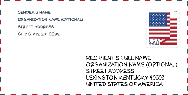
Envelope Example

This is an example of a US zip envelope. You can use a 5-digit zipcode or a detailed 9-digit zipcode to copy the mail in the following address format.
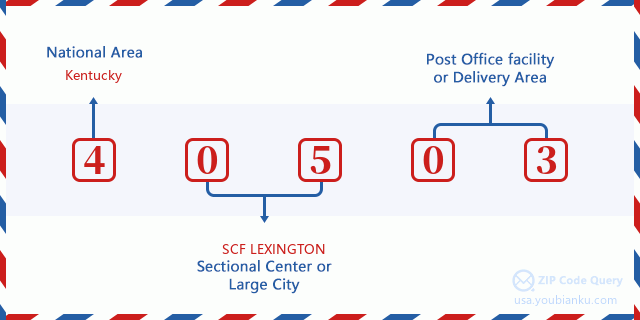
40503 Basic Meaning
What does each digit of ZIP Code 40503 stands for? The first digit designates a national area, which ranges from zero for the Northeast to nine for the far West. The 2-3 digits are the code of a sectional center facility in that region. The last two digits designate small post offices or postal zones.
Online Map

This is online map of the address Lexington, Kentucky, United States. You may use button to move and zoom in / out. The map information is for reference only.
University

This is the ZIP Code 40503 - University page list. Its detail university Name, Street, City, State, ZIP Code, Phone is as below.
| Name | Street | City | State | ZIP Code | Phone |
| Lexington Healing Arts Academy | 272 Southland Drive | Lexington | KY | 40503 | (859) 252-5656 |
| Lexington Theological Seminary | 230 Lexington Green Circle, Suite 300 | Lexington | KY | 40503 | (859) 252-0361 |
Hospital

This is the ZIP Code 40503 - Hospital page list. Its detail Hospital Name, Street, City, State, ZIP Code, Phone is as below.
- Name: BAPTIST HEALTH LEXINGTON
- Address: LEXINGTON
- City: 1740 NICHOLASVILLE ROAD
- State: KY
- ZIP Code: 40503
- Phone: (859) 260-6104
Museum

This is the ZIP Code 40503 - Museum page list. Its detail Museum Name, Street, City, State, ZIP Code, Phone is as below.
| Name | Street | City | State | ZIP Code | Phone |
| ARBORETUM STATE BOTANICAL GARDEN OF KENTUCKY | 500 ALUMNI DRIVE | LEXINGTON | KY | 40503 | |
| UNIVERSITY OF KENTUCKY - LEXINGTON ARBORETUM | 500 ALUMNI DRIVE | LEXINGTON | KY | 40503 | (859) 257-6955 |
School
This is the ZIP Code 40503 - School page list. Its detail School Name, Address, City, State, ZIP Code is as below.
| School Name | Address | City | State | Grades | ZIP Code |
|---|---|---|---|---|---|
| Scapa At Bluegrass | 400 Lafayette Pkwy | Lexington | KY | UG | 40503 |
| Lafayette High School | 401 Reed Ln | Lexington | KY | UG | 40503 |
| Clays Mill Elementary School | 2319 Clays Mill Rd | Lexington | KY | UG | 40503 |
| Wellington Elementary | 3280 Keithshire Way | Lexington | KY | UG | 40503 |
| Fayette County Preschool Center | 165 Springhill Dr | Lexington | KY | UG | 40503 |
Population for ZIP Code 40503

What is the total population in ZIP Code 40503? Below is detail information.
- Population for ZIP Code 40503: 29,427
- 2010 Population: 28,003
The 2020 demographic statistics are in progress. The current population in ZIP code 40503 is 29,427, and the population in 2010 is 28,003.
Gender

In all the statistical population, the male population is 13,827, the female population is 14,176.
- Male Population: 13,827
- Female Population: 14,176
Race

In all the statistical population, the male population is 13,827, the female population is 14,176.
- White Population: 25,101
- Black Population: 1,118
- Hispanic Population: 1,303
- Asian Population: 1,403
- Hawaiian Population: 19
- Indian Population: 150
- Other Population: 720
Age

In all the statistical population, the White population is 25,101, the Black population is 1,118, the Hispanic population is 1,303, the Asian population is 1,403, the Hawaiian population is 19, the Indian Ppopulation is 150 and Other population is 720.
- Age's Median: 37.2
- Median of male age: 34.7
- Median of female age: 39.8
Households for ZIP Code 40503
ZIP code 40503 has 12,264 households, with an average number of 2.28 persons per household. The average income per household in Zip code 40503 is 63,165 USD, and the average house value is 182,900 USD.
- Households Per Zipcode: 12,264
- Persons Per Household: 2.28
- Average House Value: 182,900
- Income Per Household: 63,165
Geographic

The latitude of the Zip code 40503 is 38.006263, the longitude is -84.534510, and the elevation is 999. It has land area of 8.846 square miles, and water area of 0.003 square miles. The time zone for ZIP code 40503 is Eastern (GMT -05:00). Daylight saving time should be observed in the area where the zip code is located.
- Latitude: 38.006263
- Longitude: -84.534510
- Elevation: 999
- Land Area: 8.846
- Water Area: 0.003
- Time Zone: Eastern (GMT -05:00)
- Region: South
- Division: East South Central
- Day Light Saving: Y
Congressional District

The Congressional District for ZIP code 40503 is Kentucky's 06th congressional district, the Congressional Land Area is 4292.72 square mile.
- Congressional District: 06th
- Congressional Land Area: 4292.72
Delivery

In the ZIP code 40503, there are 12,907 residential delivery mailboxes and centralized units, and 1,601 commercial delivery mailbox and centralized units, 9,382 single family deliveries and 1,778 multifamily deliveries, and the box count is 15,917. The main post office has city delivery carrier routes for the ZIP code 40503.
- Delivery Residential: 12,907
- Delivery Business: 1,601
- Delivery Total: 15,917
- Single Family Delivery Units: 9,382
- Multi Family Delivery Units: 1,778
- City Delivery Indicator: Y
Business

In ZIP code 40503, the number of business is 1,461, the number of employee is 23,135, the business first quarter payroll is 229,434,000 USD, the business annual payroll is 942,265,000 USD.
- Number Of Businesses: 1,461
- Number Of Employees: 23,135
- Business First Quarter Payroll: 229,434,000
- Business Annual Payroll: 942,265,000
Social Security Benefits

There are 5,290 beneficiaries with benefits in current-payment status for ZIP code 40503, of which 4,075 are retired workers, 445 are disabled workers, 345 are widow(er)s and parents, 190 are spouses and 235 are children. The number of beneficiaries aged 65 or older is 4,370. The total monthly benefits are 7,957,000 USD, of which 6,475,000 USD for retired workers, 533,000 USD for widow(er)s and parents.
- Total Number: 5,290
- Retired workers Number: 4,075
- Disabled workers Number: 445
- Widow(er)s and parents Number: 345
- Spouses Number: 190
- Children Number: 235
- All beneficiaries per month: 7,957,000
- Retired workers per month: 6,475,000
- Widow(er)s and parents per month: 533,000
- Number of beneficiaries aged 65 or older: 4,370


Add new comment