ZIP Code: 40511, Lexington, KY
ZIP Code 40511 is located in Lexington, Kentucky. Its detail State, County, City, Longitude, Latitude, Envelope Example, Population is as below.
ZIP Code 40511 Information

-
-
Country:
U.S. - United States
State:
County FIPS:
21067
County:
City:
Area Code:
City Type ?In many cases, a ZIP Code can have multiple "names", meaning cities, towns, or subdivisions, in its boundaries. However, it will ALWAYS have exactly 1 "default" name. D - Default - This is the "preferred" name - by the USPS - for a city. Each ZIP Code has one - and only one - "default" name. In most cases, this is what people who live in that area call the city as well. A - Acceptable - This name can be used for mailing purposes. Often times alternative names are large neighborhoods or sections of the city/town. In some cases a ZIP Code may have several "acceptable" names which is used to group towns under one ZIP Code. N - Not Acceptable - A "not acceptable" name is, in many cases, a nickname that residents give that location. According to the USPS, you should NOT send mail to that ZIP Code using the "not acceptable" name when mailing.:
D (Default)
ZIP Code:
40511
❓What does D (Default) mean? This is the "preferred" name - by the USPS - for a city. Each ZIP Code has one - and only one - "default" name. In most cases, this is what people who live in that area call the city as well.
ZIP Code 40511 Plus 4
ZIP Code 5 plus 4 is the extension of 5-digit zip code, It can be used to locate a more detailed location. The last four digits designate segment or one side of a street or an apartment. You can find the ZIP+4 code and corresponding address of the zip code 40511 below.
| ZIP Code 5 Plus 4 | Address |
|---|---|
| 40511-1001 | 1847 MERCER RD, LEXINGTON, KY |
| 40511-1001 | 1847 MERCER RD #D , LEXINGTON, KY |
| 40511-1002 | 1000 GEORGETOWN RD, LEXINGTON, KY |
| 40511-1003 | 1101 GEORGETOWN RD, LEXINGTON, KY |
| 40511-1004 | 1201 GEORGETOWN RD, LEXINGTON, KY |
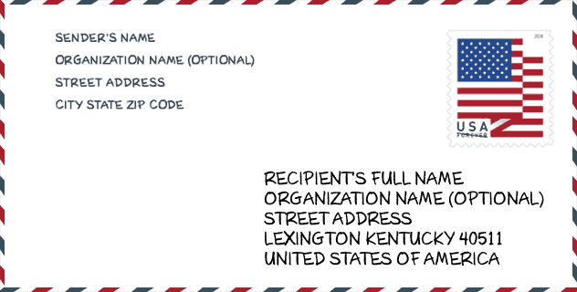
Envelope Example

This is an example of a US zip envelope. You can use a 5-digit zipcode or a detailed 9-digit zipcode to copy the mail in the following address format.
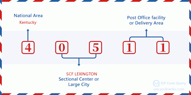
40511 Basic Meaning
What does each digit of ZIP Code 40511 stands for? The first digit designates a national area, which ranges from zero for the Northeast to nine for the far West. The 2-3 digits are the code of a sectional center facility in that region. The last two digits designate small post offices or postal zones.
Online Map

This is online map of the address Lexington, Kentucky, United States. You may use button to move and zoom in / out. The map information is for reference only.
University

This is the ZIP Code 40511 - University page list. Its detail university Name, Street, City, State, ZIP Code, Phone is as below.
| Name | Street | City | State | ZIP Code | Phone |
| MedTech College-Lexington Campus | 1648 McGrathiana Pkwy #200 | Lexington | KY | 40511 | - |
Hospital

This is the ZIP Code 40511 - Hospital page list. Its detail Hospital Name, Street, City, State, ZIP Code, Phone is as below.
- Name: EASTERN STATE HOSPITAL
- Address: LEXINGTON
- City: 1350 BULL LEA ROAD
- State: KY
- ZIP Code: 40511
- Phone: (859) 246-8000
Museum

This is the ZIP Code 40511 - Museum page list. Its detail Museum Name, Street, City, State, ZIP Code, Phone is as below.
- Name: INTERNATIONAL MUSEUM OF THE HORSE
- Street: 4089 IRON WORKS PIKE
- City: LEXINGTON
- State: KY
- ZIP Code: 40511
- Phone: (859) 259-4232
School
This is the ZIP Code 40511 - School page list. Its detail School Name, Address, City, State, ZIP Code is as below.
| School Name | Address | City | State | Grades | ZIP Code |
|---|---|---|---|---|---|
| Leestown Middle School | 2010 Leestown Rd | Lexington | KY | UG | 40511 |
| Meadowthorpe Elementary School | 1710 N. Forbes Rd | Lexington | KY | UG | 40511 |
| Winburn Middle School | 1060 Winburn Dr | Lexington | KY | UG | 40511 |
| Central Ky Technical College | 308 Vo-Tech Road | Lexington | KY | UG | 40511 |
| Blackburn Education Center | 3111 Spurr Road | Lexington | KY | UG | 40511 |
| The Stables | 4089 Iron Works Pike | Lexington | KY | UG | 40511 |
| Rise STEM Academy for Girls | 2420 SPURR RD | LEXINGTON | KY | UG | 40511 |
| Future Forward Education & Career Center | 3475 SPURR RD | LEXINGTON | KY | UG | 40511 |
Population for ZIP Code 40511

What is the total population in ZIP Code 40511? Below is detail information.
- Population for ZIP Code 40511: 35,975
- 2010 Population: 31,798
The 2020 demographic statistics are in progress. The current population in ZIP code 40511 is 35,975, and the population in 2010 is 31,798.
Gender

In all the statistical population, the male population is 16,617, the female population is 15,181.
- Male Population: 16,617
- Female Population: 15,181
Race

In all the statistical population, the male population is 16,617, the female population is 15,181.
- White Population: 18,858
- Black Population: 10,178
- Hispanic Population: 4,532
- Asian Population: 615
- Hawaiian Population: 28
- Indian Population: 386
- Other Population: 2,746
Age

In all the statistical population, the White population is 18,858, the Black population is 10,178, the Hispanic population is 4,532, the Asian population is 615, the Hawaiian population is 28, the Indian Ppopulation is 386 and Other population is 2,746.
- Age's Median: 33.2
- Median of male age: 33.1
- Median of female age: 33.3
Households for ZIP Code 40511
ZIP code 40511 has 11,536 households, with an average number of 2.51 persons per household. The average income per household in Zip code 40511 is 60,774 USD, and the average house value is 147,700 USD.
- Households Per Zipcode: 11,536
- Persons Per Household: 2.51
- Average House Value: 147,700
- Income Per Household: 60,774
Geographic

The latitude of the Zip code 40511 is 38.134518, the longitude is -84.490494, and the elevation is 941. It has land area of 88.552 square miles, and water area of 0.392 square miles. The time zone for ZIP code 40511 is Eastern (GMT -05:00). Daylight saving time should be observed in the area where the zip code is located.
- Latitude: 38.134518
- Longitude: -84.490494
- Elevation: 941
- Land Area: 88.552
- Water Area: 0.392
- Time Zone: Eastern (GMT -05:00)
- Region: South
- Division: East South Central
- Day Light Saving: Y
Congressional District

The Congressional District for ZIP code 40511 is Kentucky's 06th congressional district, the Congressional Land Area is 4292.72 square mile.
- Congressional District: 06th
- Congressional Land Area: 4292.72
Delivery

In the ZIP code 40511, there are 14,333 residential delivery mailboxes and centralized units, and 1,074 commercial delivery mailbox and centralized units, 8,695 single family deliveries and 1,516 multifamily deliveries, and the box count is 15,170. The main post office has city delivery carrier routes for the ZIP code 40511.
- Delivery Residential: 14,333
- Delivery Business: 1,074
- Delivery Total: 15,170
- Single Family Delivery Units: 8,695
- Multi Family Delivery Units: 1,516
- City Delivery Indicator: Y
Business

In ZIP code 40511, the number of business is 986, the number of employee is 28,470, the business first quarter payroll is 325,118,000 USD, the business annual payroll is 1,320,918,000 USD.
- Number Of Businesses: 986
- Number Of Employees: 28,470
- Business First Quarter Payroll: 325,118,000
- Business Annual Payroll: 1,320,918,000
Social Security Benefits

There are 4,650 beneficiaries with benefits in current-payment status for ZIP code 40511, of which 3,190 are retired workers, 750 are disabled workers, 260 are widow(er)s and parents, 110 are spouses and 340 are children. The number of beneficiaries aged 65 or older is 3,300. The total monthly benefits are 6,242,000 USD, of which 4,627,000 USD for retired workers, 363,000 USD for widow(er)s and parents.
- Total Number: 4,650
- Retired workers Number: 3,190
- Disabled workers Number: 750
- Widow(er)s and parents Number: 260
- Spouses Number: 110
- Children Number: 340
- All beneficiaries per month: 6,242,000
- Retired workers per month: 4,627,000
- Widow(er)s and parents per month: 363,000
- Number of beneficiaries aged 65 or older: 3,300


Add new comment