United States ZIP Code: 41048
This is the Kentucky ZIP Code 41048 page list. Its detail State, County, City, Longitude, Latitude, Envelope Example, Population is as below.

ZIP Code 41048 Information

-
-
Country:
U.S. - United States
State:
State FIPS:
21
Area Code:
ZIP Code:
41048
ZIP Type:
S (Standard)
❓What does S (Standard) mean? A "standard" ZIP Code is what most people think of when they talk about ZIP Codes - essentially a town, city, or a division of a city that has mail service.
ZIP Code 41048 - City

This is the city information corresponding to 41048:
| State | County | City | City Type ?In many cases, a ZIP Code can have multiple "names", meaning cities, towns, or subdivisions, in its boundaries. However, it will ALWAYS have exactly 1 "default" name. D - Default - This is the "preferred" name - by the USPS - for a city. Each ZIP Code has one - and only one - "default" name. In most cases, this is what people who live in that area call the city as well. A - Acceptable - This name can be used for mailing purposes. Often times alternative names are large neighborhoods or sections of the city/town. In some cases a ZIP Code may have several "acceptable" names which is used to group towns under one ZIP Code. N - Not Acceptable - A "not acceptable" name is, in many cases, a nickname that residents give that location. According to the USPS, you should NOT send mail to that ZIP Code using the "not acceptable" name when mailing. | ZIP Code |
|---|---|---|---|---|
| KY | Boone | Francisville | N (Not Acceptable) | 41048 |
| KY | Boone | Hebron | D (Default) | 41048 |
| KY | Boone | Taylorsport | N (Not Acceptable) | 41048 |
❓What does D (Default) mean? This is the "preferred" name - by the USPS - for a city. Each ZIP Code has one - and only one - "default" name. In most cases, this is what people who live in that area call the city as well.
❓What does N (Not Acceptable) mean? A "not acceptable" name is, in many cases, a nickname that residents give that location. According to the USPS, you should NOT send mail to that ZIP Code using the "not acceptable" name when mailing.
ZIP Code 41048 Plus 4
ZIP Code 5 plus 4 is the extension of 5-digit zip code, It can be used to locate a more detailed location. The last four digits designate segment or one side of a street or an apartment. You can find the ZIP+4 code and corresponding address of the zip code 41048 below.
| ZIP Code 5 Plus 4 | Address |
|---|---|
| 41048-0001 | PO BOX 1, HEBRON, KY |
| 41048-0121 | PO BOX 121, HEBRON, KY |
| 41048-0251 | PO BOX 251, HEBRON, KY |
| 41048-0381 | PO BOX 381, HEBRON, KY |
| 41048-0501 | PO BOX 501, HEBRON, KY |
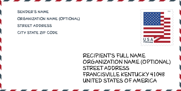
Envelope Example

This is an example of a US zip envelope. You can use a 5-digit zipcode or a detailed 9-digit zipcode to copy the mail in the following address format.
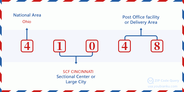
41048 Basic Meaning
What does each digit of ZIP Code 41048 stands for? The first digit designates a national area, which ranges from zero for the Northeast to nine for the far West. The 2-3 digits are the code of a sectional center facility in that region. The last two digits designate small post offices or postal zones.
Online Map

This is online map of the address Taylorsport, Kentucky, United States. You may use button to move and zoom in / out. The map information is for reference only.
School

This is the ZIP Code 41048 - School page list. Its detail School Name, Address, City, State, ZIP Code is as below.
| School Name | Address | City | State | Grades | ZIP Code |
|---|---|---|---|---|---|
| Boone County Area Technology Center | 3320 Cougar Path | Hebron | KY | UG | 41048 |
| Conner Middle School | 3300 Cougar Path | Hebron | KY | UG | 41048 |
| Conner High School | 3310 Cougar Path | Hebron | KY | UG | 41048 |
| North Pointe Elementary School | 875 North Bend Rd | Hebron | KY | UG | 41048 |
| Thornwilde Elementary School | 1760 Elmburn Ln | Hebron | KY | UG | 41048 |
Population for ZIP Code 41048

What is the total population in ZIP Code 41048? Below is detail information.
- Population for ZIP Code 41048: 17,175
- 2010 Population: 13,959
The 2020 demographic statistics are in progress. The current population in ZIP code 41048 is 17,175, and the population in 2010 is 13,959.
Gender

In all the statistical population, the male population is 6,947, the female population is 7,012.
- Male Population: 6,947
- Female Population: 7,012
Race

In all the statistical population, the male population is 6,947, the female population is 7,012.
- White Population: 13,208
- Black Population: 383
- Hispanic Population: 393
- Asian Population: 396
- Hawaiian Population: 8
- Indian Population: 105
- Other Population: 182
Age

In all the statistical population, the White population is 13,208, the Black population is 383, the Hispanic population is 393, the Asian population is 396, the Hawaiian population is 8, the Indian Ppopulation is 105 and Other population is 182.
- Age's Median: 32.5
- Median of male age: 32.8
- Median of female age: 32.3
Households for ZIP Code 41048
ZIP code 41048 has 4,475 households, with an average number of 3.12 persons per household. The average income per household in Zip code 41048 is 98,304 USD, and the average house value is 217,800 USD.
- Households Per Zipcode: 4,475
- Persons Per Household: 3.12
- Average House Value: 217,800
- Income Per Household: 98,304
Housing Unit

In ZIP code 41048, the growth rank of housing unit is 95, the number of housing unit was 118,811 in 2010 and increased to 121,737 in 2011, the growth increase number is 2,926, the growth increase percentage is 2.5%.
- Growth Rank: 95
- Housing Units Estimate in 2010: 118,811
- Housing Units Estimate in 2011: 121,737
- Growth Increase Number: 2,926
- Growth Increase Percentage: 2.5%
Geographic

The latitude of the Zip code 41048 is 39.091848, the longitude is -84.703660, and the elevation is 748. It has land area of 21.993 square miles, and water area of 2.732 square miles. The time zone for ZIP code 41048 is Eastern (GMT -05:00). Daylight saving time should be observed in the area where the zip code is located.
- Latitude: 39.091848
- Longitude: -84.703660
- Elevation: 748
- Land Area: 21.993
- Water Area: 2.732
- Time Zone: Eastern (GMT -05:00)
- Region: South
- Division: East South Central
- Day Light Saving: Y
Congressional District

The Congressional District for ZIP code 41048 is Kentucky's 04th congressional district, the Congressional Land Area is 4382.19 square mile.
- Congressional District: 04th
- Congressional Land Area: 4382.19
Delivery

In the ZIP code 41048, there are 5,505 residential delivery mailboxes and centralized units, and 379 commercial delivery mailbox and centralized units, 4,188 single family deliveries and 250 multifamily deliveries, and the box count is 6,020. The main post office does not have city delivery carrier routes for the ZIP code 41048.
- Delivery Residential: 5,505
- Delivery Business: 379
- Delivery Total: 6,020
- Single Family Delivery Units: 4,188
- Multi Family Delivery Units: 250
- City Delivery Indicator: N
Business

In ZIP code 41048, the number of business is 450, the number of employee is 20,743, the business first quarter payroll is 223,012,000 USD, the business annual payroll is 934,379,000 USD.
- Number Of Businesses: 450
- Number Of Employees: 20,743
- Business First Quarter Payroll: 223,012,000
- Business Annual Payroll: 934,379,000
Social Security Benefits

There are 1,920 beneficiaries with benefits in current-payment status for ZIP code 41048, of which 1,285 are retired workers, 265 are disabled workers, 90 are widow(er)s and parents, 80 are spouses and 200 are children. The number of beneficiaries aged 65 or older is 1,345. The total monthly benefits are 2,828,000 USD, of which 2,090,000 USD for retired workers, 134,000 USD for widow(er)s and parents.
- Total Number: 1,920
- Retired workers Number: 1,285
- Disabled workers Number: 265
- Widow(er)s and parents Number: 90
- Spouses Number: 80
- Children Number: 200
- All beneficiaries per month: 2,828,000
- Retired workers per month: 2,090,000
- Widow(er)s and parents per month: 134,000
- Number of beneficiaries aged 65 or older: 1,345


Add new comment