ZIP Code: 42066, Mayfield, KY
ZIP Code 42066 is located in Mayfield, Kentucky. Its detail State, County, City, Longitude, Latitude, Envelope Example, Population is as below.

ZIP Code 42066 Information

-
-
Country:
U.S. - United States
State:
County FIPS:
21083
County:
City:
Area Code:
City Type ?In many cases, a ZIP Code can have multiple "names", meaning cities, towns, or subdivisions, in its boundaries. However, it will ALWAYS have exactly 1 "default" name. D - Default - This is the "preferred" name - by the USPS - for a city. Each ZIP Code has one - and only one - "default" name. In most cases, this is what people who live in that area call the city as well. A - Acceptable - This name can be used for mailing purposes. Often times alternative names are large neighborhoods or sections of the city/town. In some cases a ZIP Code may have several "acceptable" names which is used to group towns under one ZIP Code. N - Not Acceptable - A "not acceptable" name is, in many cases, a nickname that residents give that location. According to the USPS, you should NOT send mail to that ZIP Code using the "not acceptable" name when mailing.:
D (Default)
ZIP Code:
42066
❓What does D (Default) mean? This is the "preferred" name - by the USPS - for a city. Each ZIP Code has one - and only one - "default" name. In most cases, this is what people who live in that area call the city as well.
ZIP Code 42066 Plus 4
ZIP Code 5 plus 4 is the extension of 5-digit zip code, It can be used to locate a more detailed location. The last four digits designate segment or one side of a street or an apartment. You can find the ZIP+4 code and corresponding address of the zip code 42066 below.
| ZIP Code 5 Plus 4 | Address |
|---|---|
| 42066-0001 | PO BOX 5490, MAYFIELD, KY |
| 42066-0002 | PO BOX 1, MAYFIELD, KY |
| 42066-0003 | PO BOX 0, MAYFIELD, KY |
| 42066-0004 | PO BOX 0, MAYFIELD, KY |
| 42066-0005 | PO BOX 0, MAYFIELD, KY |
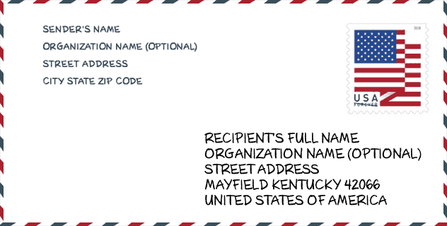
Envelope Example

This is an example of a US zip envelope. You can use a 5-digit zipcode or a detailed 9-digit zipcode to copy the mail in the following address format.
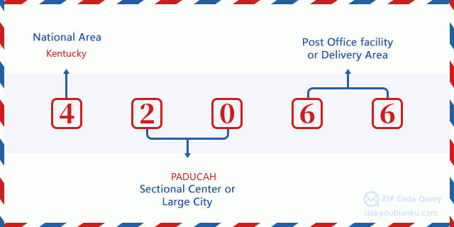
42066 Basic Meaning
What does each digit of ZIP Code 42066 stands for? The first digit designates a national area, which ranges from zero for the Northeast to nine for the far West. The 2-3 digits are the code of a sectional center facility in that region. The last two digits designate small post offices or postal zones.
Online Map

This is online map of the address Mayfield, Kentucky, United States. You may use button to move and zoom in / out. The map information is for reference only.
Hospital

This is the ZIP Code 42066 - Hospital page list. Its detail Hospital Name, Street, City, State, ZIP Code, Phone is as below.
- Name: JACKSON PURCHASE MEDICAL CENTER
- Address: MAYFIELD
- City: 1099 MEDICAL CENTER CIRCLE
- State: KY
- ZIP Code: 42066
- Phone: (270) 251-4585
Library

This is the ZIP Code 42066 - Library page list. Its detail Library Name, Address, City, State, ZIP Code, Phone is as below.
| Name | Address | City | State | ZIP Code | Phone |
|---|---|---|---|---|---|
| GRAVES COUNTY LIBRARY | 601 NORTH 17TH STREET | MAYFIELD | KY | 42066 | (270) 247-2911 |
| GRAVES COUNTY PUBLIC LIBRARY | 601 NORTH 17TH STREET | MAYFIELD | KY | 42066 | (270) 247-2911 |
School

This is the ZIP Code 42066 - School page list. Its detail School Name, Address, City, State, ZIP Code is as below.
| School Name | Address | City | State | Grades | ZIP Code |
|---|---|---|---|---|---|
| Mayfield/Graves County Area Tech Center | 710 Douthitt Street | Mayfield | KY | UG | 42066 |
| Farmington Elementary School | 7730 State Rt 121 S | Mayfield | KY | UG | 42066 |
| Sedalia Elementary School | 5252 St. Rt 97 | Mayfield | KY | UG | 42066 |
| Graves County Middle School | 625 Jimtown Rd | Mayfield | KY | UG | 42066 |
| Graves County High School | 1220 EAGLES WAY | Mayfield | KY | UG | 42066 |
| Mayfield Youth Development Center | 3179 State Rt 45 S | Mayfield | KY | UG | 42066 |
| Gateway Academy High School | 1211 Eagles Way | Mayfield | KY | UG | 42066 |
| Graves County Central Elementary | 2262 State Rt 121 N | Mayfield | KY | UG | 42066 |
| Mayfield High School | 700 Douthitt St | Mayfield | KY | UG | 42066 |
| Mayfield Middle School | 112 W College St | Mayfield | KY | UG | 42066 |
| Mayfield Elementary School | 1004 Backusburg Rd | Mayfield | KY | UG | 42066 |
Population for ZIP Code 42066

What is the total population in ZIP Code 42066? Below is detail information.
- Population for ZIP Code 42066: 23,316
- 2010 Population: 23,182
The 2020 demographic statistics are in progress. The current population in ZIP code 42066 is 23,316, and the population in 2010 is 23,182.
Gender

In all the statistical population, the male population is 11,266, the female population is 11,916.
- Male Population: 11,266
- Female Population: 11,916
Race

In all the statistical population, the male population is 11,266, the female population is 11,916.
- White Population: 20,607
- Black Population: 1,800
- Hispanic Population: 1,841
- Asian Population: 120
- Hawaiian Population: 24
- Indian Population: 172
- Other Population: 980
Age

In all the statistical population, the White population is 20,607, the Black population is 1,800, the Hispanic population is 1,841, the Asian population is 120, the Hawaiian population is 24, the Indian Ppopulation is 172 and Other population is 980.
- Age's Median: 39.4
- Median of male age: 37.8
- Median of female age: 41.2
Households for ZIP Code 42066
ZIP code 42066 has 9,391 households, with an average number of 2.41 persons per household. The average income per household in Zip code 42066 is 39,213 USD, and the average house value is 101,900 USD.
- Households Per Zipcode: 9,391
- Persons Per Household: 2.41
- Average House Value: 101,900
- Income Per Household: 39,213
Geographic

The latitude of the Zip code 42066 is 36.710738, the longitude is -88.649882, and the elevation is 508. It has land area of 216.838 square miles, and water area of 2.381 square miles. The time zone for ZIP code 42066 is Central (GMT -06:00). Daylight saving time should be observed in the area where the zip code is located.
- Latitude: 36.710738
- Longitude: -88.649882
- Elevation: 508
- Land Area: 216.838
- Water Area: 2.381
- Time Zone: Central (GMT -06:00)
- Region: South
- Division: East South Central
- Day Light Saving: Y
Congressional District

The Congressional District for ZIP code 42066 is Kentucky's 1st congressional district, the Congressional Land Area is 12079.5 square mile.
- Congressional District: 1st
- Congressional Land Area: 12079.5
Delivery

In the ZIP code 42066, there are 9,675 residential delivery mailboxes and centralized units, and 623 commercial delivery mailbox and centralized units, 8,811 single family deliveries and 116 multifamily deliveries, and the box count is 10,914. The main post office has city delivery carrier routes for the ZIP code 42066.
- Delivery Residential: 9,675
- Delivery Business: 623
- Delivery Total: 10,914
- Single Family Delivery Units: 8,811
- Multi Family Delivery Units: 116
- City Delivery Indicator: Y
Business

In ZIP code 42066, the number of business is 530, the number of employee is 6,947, the business first quarter payroll is 60,260,000 USD, the business annual payroll is 249,731,000 USD.
- Number Of Businesses: 530
- Number Of Employees: 6,947
- Business First Quarter Payroll: 60,260,000
- Business Annual Payroll: 249,731,000
Social Security Benefits

There are 5,895 beneficiaries with benefits in current-payment status for ZIP code 42066, of which 3,765 are retired workers, 1,095 are disabled workers, 440 are widow(er)s and parents, 205 are spouses and 390 are children. The number of beneficiaries aged 65 or older is 4,120. The total monthly benefits are 7,422,000 USD, of which 5,210,000 USD for retired workers, 571,000 USD for widow(er)s and parents.
- Total Number: 5,895
- Retired workers Number: 3,765
- Disabled workers Number: 1,095
- Widow(er)s and parents Number: 440
- Spouses Number: 205
- Children Number: 390
- All beneficiaries per month: 7,422,000
- Retired workers per month: 5,210,000
- Widow(er)s and parents per month: 571,000
- Number of beneficiaries aged 65 or older: 4,120


Add new comment