United States ZIP Code: 45011
This is the Ohio ZIP Code 45011 page list. Its detail State, County, City, Longitude, Latitude, Envelope Example, Population is as below.

ZIP Code 45011 Information

ZIP Code 45011 - City

This is the city information corresponding to 45011:
| State | County | City | City Type ?In many cases, a ZIP Code can have multiple "names", meaning cities, towns, or subdivisions, in its boundaries. However, it will ALWAYS have exactly 1 "default" name. D - Default - This is the "preferred" name - by the USPS - for a city. Each ZIP Code has one - and only one - "default" name. In most cases, this is what people who live in that area call the city as well. A - Acceptable - This name can be used for mailing purposes. Often times alternative names are large neighborhoods or sections of the city/town. In some cases a ZIP Code may have several "acceptable" names which is used to group towns under one ZIP Code. N - Not Acceptable - A "not acceptable" name is, in many cases, a nickname that residents give that location. According to the USPS, you should NOT send mail to that ZIP Code using the "not acceptable" name when mailing. | ZIP Code |
|---|---|---|---|---|
| OH | Butler | City View Heights | N (Not Acceptable) | 45011 |
| OH | Butler | Fairfield | A (Acceptable) | 45011 |
| OH | Butler | Fairfield Township | A (Acceptable) | 45011 |
| OH | Butler | Fairfield Twp | A (Acceptable) | 45011 |
| OH | Butler | Hamilton | D (Default) | 45011 |
| OH | Butler | Indian Spgs | A (Acceptable) | 45011 |
| OH | Butler | Liberty Twp | A (Acceptable) | 45011 |
| OH | Butler | New Miami | N (Not Acceptable) | 45011 |
| OH | Butler | Saint Clair | N (Not Acceptable) | 45011 |
| OH | Butler | Village Of Indian Springs | A (Acceptable) | 45011 |
| OH | Butler | West Chester | A (Acceptable) | 45011 |
❓What does D (Default) mean? This is the "preferred" name - by the USPS - for a city. Each ZIP Code has one - and only one - "default" name. In most cases, this is what people who live in that area call the city as well.
❓What does A (Acceptable) mean? This name can be used for mailing purposes. Often times alternative names are large neighborhoods or sections of the city/town. In some cases a ZIP Code may have several "acceptable" names which is used to group towns under one ZIP Code.
❓What does N (Not Acceptable) mean? A "not acceptable" name is, in many cases, a nickname that residents give that location. According to the USPS, you should NOT send mail to that ZIP Code using the "not acceptable" name when mailing.
ZIP Code 45011 Plus 4
ZIP Code 5 plus 4 is the extension of 5-digit zip code, It can be used to locate a more detailed location. The last four digits designate segment or one side of a street or an apartment. You can find the ZIP+4 code and corresponding address of the zip code 45011 below.
| ZIP Code 5 Plus 4 | Address |
|---|---|
| 45011-5586 | 3900 ERDING CT, FAIRFIELD, OH |
| 45011-8060 | 200 LANCASTER DR, FAIRFIELD, OH |
| 45011-8061 | 201 LANCASTER DR, FAIRFIELD, OH |
| 45011-8067 | 400 LOREN LN, FAIRFIELD, OH |
| 45011-8068 | 500 LOREN LN, FAIRFIELD, OH |
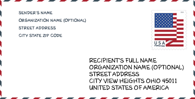
Envelope Example

This is an example of a US zip envelope. You can use a 5-digit zipcode or a detailed 9-digit zipcode to copy the mail in the following address format.
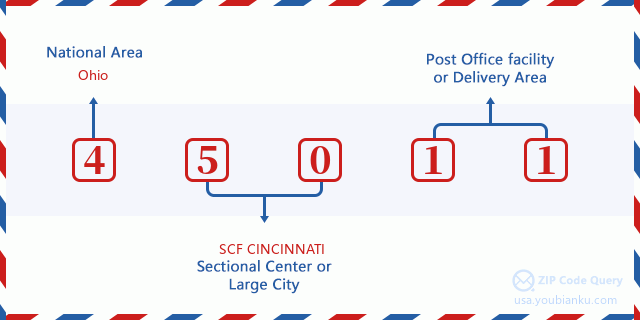
45011 Basic Meaning
What does each digit of ZIP Code 45011 stands for? The first digit designates a national area, which ranges from zero for the Northeast to nine for the far West. The 2-3 digits are the code of a sectional center facility in that region. The last two digits designate small post offices or postal zones.
Online Map

This is online map of the address West Chester, Ohio, United States. You may use button to move and zoom in / out. The map information is for reference only.
University

This is the ZIP Code 45011 - University page list. Its detail university Name, Street, City, State, ZIP Code, Phone is as below.
| Name | Street | City | State | ZIP Code | Phone |
| Butler Tech-D Russel Lee Career Center | 3603 Hamilton Middletown Rd | Hamilton | OH | 45011 | - |
| Miami University-Hamilton | 1601 University Blvd | Hamilton | OH | 45011 | (513) 785-3000 |
Museum

This is the ZIP Code 45011 - Museum page list. Its detail Museum Name, Street, City, State, ZIP Code, Phone is as below.
| Name | Street | City | State | ZIP Code | Phone |
| LANE-HOOVEN HOUSE | 319 N 3RD ST | HAMILTON | OH | 45011 | (513) 863-1389 |
| HISTORIC HAMILTON | 319 N THIRD STREET | HAMILTON | OH | 45011 | (513) 863-1389 |
| DAYTON LANE HISTORIC AREA | 712 DAYTON STREET | HAMILTON | OH | 45011 | |
| SEVEN MILE HISTORICAL SOCIETY | 3750 MORGANTHALER RD | HAMILTON | OH | 45011 |
Library

This is the ZIP Code 45011 - Library page list. Its detail Library Name, Address, City, State, ZIP Code, Phone is as below.
| Name | Address | City | State | ZIP Code | Phone |
|---|---|---|---|---|---|
| HAMILTON LANE BRANCH | 300 N THIRD ST | HAMILTON | OH | 45011 | (513) 894-7156 |
| LANE PUBLIC LIBRARY | 300 N. THIRD ST. | HAMILTON | OH | 45011 | (513) 894-7156 |
School
This is the ZIP Code 45011 - School page list. Its detail School Name, Address, City, State, ZIP Code is as below.
| School Name | Address | City | State | Grades | ZIP Code |
|---|---|---|---|---|---|
| Fairwood Elementary School | 281 Fair Avenue | Hamilton | OH | UG | 45011 |
| Lakota Plains Junior School | 5500 Princeton Road | Liberty Township | OH | UG | 45011 |
Population for ZIP Code 45011

What is the total population in ZIP Code 45011? Below is detail information.
- Population for ZIP Code 45011: 75,776
- 2010 Population: 69,677
The 2020 demographic statistics are in progress. The current population in ZIP code 45011 is 75,776, and the population in 2010 is 69,677.
Gender

In all the statistical population, the male population is 34,811, the female population is 34,866.
- Male Population: 34,811
- Female Population: 34,866
Race

In all the statistical population, the male population is 34,811, the female population is 34,866.
- White Population: 57,700
- Black Population: 8,476
- Hispanic Population: 4,695
- Asian Population: 1,998
- Hawaiian Population: 134
- Indian Population: 522
- Other Population: 2,635
Age

In all the statistical population, the White population is 57,700, the Black population is 8,476, the Hispanic population is 4,695, the Asian population is 1,998, the Hawaiian population is 134, the Indian Ppopulation is 522 and Other population is 2,635.
- Age's Median: 34.8
- Median of male age: 33.9
- Median of female age: 35.7
Households for ZIP Code 45011
ZIP code 45011 has 23,732 households, with an average number of 2.87 persons per household. The average income per household in Zip code 45011 is 66,887 USD, and the average house value is 177,500 USD.
- Households Per Zipcode: 23,732
- Persons Per Household: 2.87
- Average House Value: 177,500
- Income Per Household: 66,887
Geographic

The latitude of the Zip code 45011 is 39.426896, the longitude is -84.497486, and the elevation is 603. It has land area of 60.544 square miles, and water area of 0.699 square miles. The time zone for ZIP code 45011 is Eastern (GMT -05:00). Daylight saving time should be observed in the area where the zip code is located.
- Latitude: 39.426896
- Longitude: -84.497486
- Elevation: 603
- Land Area: 60.544
- Water Area: 0.699
- Time Zone: Eastern (GMT -05:00)
- Region: Midwest
- Division: East North Central
- Day Light Saving: Y
Congressional District

The Congressional District for ZIP code 45011 is Ohio's 08th congressional district, the Congressional Land Area is 2450.49 square mile.
- Congressional District: 08th
- Congressional Land Area: 2450.49
Delivery

In the ZIP code 45011, there are 26,403 residential delivery mailboxes and centralized units, and 1,466 commercial delivery mailbox and centralized units, 21,871 single family deliveries and 2,318 multifamily deliveries, and the box count is 28,121. The main post office has city delivery carrier routes for the ZIP code 45011.
- Delivery Residential: 26,403
- Delivery Business: 1,466
- Delivery Total: 28,121
- Single Family Delivery Units: 21,871
- Multi Family Delivery Units: 2,318
- City Delivery Indicator: Y
Business

In ZIP code 45011, the number of business is 1,066, the number of employee is 19,421, the business first quarter payroll is 205,991,000 USD, the business annual payroll is 817,672,000 USD.
- Number Of Businesses: 1,066
- Number Of Employees: 19,421
- Business First Quarter Payroll: 205,991,000
- Business Annual Payroll: 817,672,000
Social Security Benefits

There are 11,685 beneficiaries with benefits in current-payment status for ZIP code 45011, of which 7,315 are retired workers, 2,120 are disabled workers, 795 are widow(er)s and parents, 420 are spouses and 1,035 are children. The number of beneficiaries aged 65 or older is 7,970. The total monthly benefits are 16,099,000 USD, of which 11,328,000 USD for retired workers, 1,062,000 USD for widow(er)s and parents.
- Total Number: 11,685
- Retired workers Number: 7,315
- Disabled workers Number: 2,120
- Widow(er)s and parents Number: 795
- Spouses Number: 420
- Children Number: 1,035
- All beneficiaries per month: 16,099,000
- Retired workers per month: 11,328,000
- Widow(er)s and parents per month: 1,062,000
- Number of beneficiaries aged 65 or older: 7,970


Add new comment