United States ZIP Code: 45042
This is the Ohio ZIP Code 45042 page list. Its detail State, County, City, Longitude, Latitude, Envelope Example, Population is as below.

ZIP Code 45042 Information

ZIP Code 45042 - City

This is the city information corresponding to 45042:
| State | County | City | City Type ?In many cases, a ZIP Code can have multiple "names", meaning cities, towns, or subdivisions, in its boundaries. However, it will ALWAYS have exactly 1 "default" name. D - Default - This is the "preferred" name - by the USPS - for a city. Each ZIP Code has one - and only one - "default" name. In most cases, this is what people who live in that area call the city as well. A - Acceptable - This name can be used for mailing purposes. Often times alternative names are large neighborhoods or sections of the city/town. In some cases a ZIP Code may have several "acceptable" names which is used to group towns under one ZIP Code. N - Not Acceptable - A "not acceptable" name is, in many cases, a nickname that residents give that location. According to the USPS, you should NOT send mail to that ZIP Code using the "not acceptable" name when mailing. | ZIP Code |
|---|---|---|---|---|
| OH | Butler | Bethany | N (Not Acceptable) | 45042 |
| OH | Butler | Middletown | D (Default) | 45042 |
| OH | Butler | W Middletown | N (Not Acceptable) | 45042 |
❓What does D (Default) mean? This is the "preferred" name - by the USPS - for a city. Each ZIP Code has one - and only one - "default" name. In most cases, this is what people who live in that area call the city as well.
❓What does N (Not Acceptable) mean? A "not acceptable" name is, in many cases, a nickname that residents give that location. According to the USPS, you should NOT send mail to that ZIP Code using the "not acceptable" name when mailing.
ZIP Code 45042 Plus 4
ZIP Code 5 plus 4 is the extension of 5-digit zip code, It can be used to locate a more detailed location. The last four digits designate segment or one side of a street or an apartment. You can find the ZIP+4 code and corresponding address of the zip code 45042 below.
| ZIP Code 5 Plus 4 | Address |
|---|---|
| 45042-0001 | PO BOX 1, MIDDLETOWN, OH |
| 45042-0070 | PO BOX 42070, MIDDLETOWN, OH |
| 45042-0190 | PO BOX 42190, MIDDLETOWN, OH |
| 45042-0217 | PO BOX 42217, MIDDLETOWN, OH |
| 45042-0221 | PO BOX 42221, MIDDLETOWN, OH |
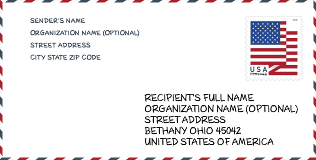
Envelope Example

This is an example of a US zip envelope. You can use a 5-digit zipcode or a detailed 9-digit zipcode to copy the mail in the following address format.
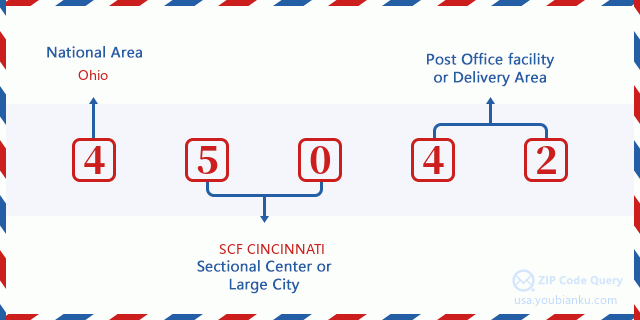
45042 Basic Meaning
What does each digit of ZIP Code 45042 stands for? The first digit designates a national area, which ranges from zero for the Northeast to nine for the far West. The 2-3 digits are the code of a sectional center facility in that region. The last two digits designate small post offices or postal zones.
Online Map

This is online map of the address W Middletown, Ohio, United States. You may use button to move and zoom in / out. The map information is for reference only.
University

This is the ZIP Code 45042 - University page list. Its detail university Name, Street, City, State, ZIP Code, Phone is as below.
| Name | Street | City | State | ZIP Code | Phone |
| Miami University-Middletown | 4200 E University Blvd | Middletown | OH | 45042 | (513) 727-3200 |
Museum

This is the ZIP Code 45042 - Museum page list. Its detail Museum Name, Street, City, State, ZIP Code, Phone is as below.
| Name | Street | City | State | ZIP Code | Phone |
| MIDDLETOWN HISTORICAL SOCIETY CANAL MUSEUM | 1605 N VERITY PKWY | MIDDLETOWN | OH | 45042 | (513) 422-7161 |
| BULLS RUN ARBORETUM | PO BOX 425 | MIDDLETOWN | OH | 45042 | (513) 422-5063 |
| HISTORICAL SOCIETY OF MADISON TOWNSHIP | 6120 MICHAEL RD | MIDDLETOWN | OH | 45042 | (513) 423-4132 |
School
This is the ZIP Code 45042 - School page list. Its detail School Name, Address, City, State, ZIP Code is as below.
- School Name: Miller Ridge Elementary School
- Address: 4704 Miller Road
- City: Middletown
- State: OH
- Grades: UG
- ZIP Code: 45042
Population for ZIP Code 45042

What is the total population in ZIP Code 45042? Below is detail information.
- Population for ZIP Code 45042: 27,662
- 2010 Population: 26,451
The 2020 demographic statistics are in progress. The current population in ZIP code 45042 is 27,662, and the population in 2010 is 26,451.
Gender

In all the statistical population, the male population is 12,939, the female population is 13,512.
- Male Population: 12,939
- Female Population: 13,512
Race

In all the statistical population, the male population is 12,939, the female population is 13,512.
- White Population: 25,352
- Black Population: 1,087
- Hispanic Population: 280
- Asian Population: 171
- Hawaiian Population: 29
- Indian Population: 155
- Other Population: 108
Age

In all the statistical population, the White population is 25,352, the Black population is 1,087, the Hispanic population is 280, the Asian population is 171, the Hawaiian population is 29, the Indian Ppopulation is 155 and Other population is 108.
- Age's Median: 42.2
- Median of male age: 41.2
- Median of female age: 43.2
Households for ZIP Code 45042
ZIP code 45042 has 10,766 households, with an average number of 2.44 persons per household. The average income per household in Zip code 45042 is 55,883 USD, and the average house value is 135,300 USD.
- Households Per Zipcode: 10,766
- Persons Per Household: 2.44
- Average House Value: 135,300
- Income Per Household: 55,883
Geographic

The latitude of the Zip code 45042 is 39.547031, the longitude is -84.438184, and the elevation is 852. It has land area of 49.321 square miles, and water area of 0.618 square miles. The time zone for ZIP code 45042 is Eastern (GMT -05:00). Daylight saving time should be observed in the area where the zip code is located.
- Latitude: 39.547031
- Longitude: -84.438184
- Elevation: 852
- Land Area: 49.321
- Water Area: 0.618
- Time Zone: Eastern (GMT -05:00)
- Region: Midwest
- Division: East North Central
- Day Light Saving: Y
Congressional District

The Congressional District for ZIP code 45042 is Ohio's 1st|08th|10th congressional district, the Congressional Land Area is 686.96|2450.49|1129.76 square mile.
- Congressional District: 1st|08th|10th
- Congressional Land Area: 686.96|2450.49|1129.76
Delivery

In the ZIP code 45042, there are 11,337 residential delivery mailboxes and centralized units, and 420 commercial delivery mailbox and centralized units, 9,835 single family deliveries and 1,178 multifamily deliveries, and the box count is 12,395. The main post office has city delivery carrier routes for the ZIP code 45042.
- Delivery Residential: 11,337
- Delivery Business: 420
- Delivery Total: 12,395
- Single Family Delivery Units: 9,835
- Multi Family Delivery Units: 1,178
- City Delivery Indicator: Y
Business

In ZIP code 45042, the number of business is 367, the number of employee is 4,115, the business first quarter payroll is 43,656,000 USD, the business annual payroll is 181,123,000 USD.
- Number Of Businesses: 367
- Number Of Employees: 4,115
- Business First Quarter Payroll: 43,656,000
- Business Annual Payroll: 181,123,000
Social Security Benefits

There are 6,325 beneficiaries with benefits in current-payment status for ZIP code 45042, of which 4,175 are retired workers, 975 are disabled workers, 515 are widow(er)s and parents, 275 are spouses and 385 are children. The number of beneficiaries aged 65 or older is 4,670. The total monthly benefits are 8,893,000 USD, of which 6,411,000 USD for retired workers, 739,000 USD for widow(er)s and parents.
- Total Number: 6,325
- Retired workers Number: 4,175
- Disabled workers Number: 975
- Widow(er)s and parents Number: 515
- Spouses Number: 275
- Children Number: 385
- All beneficiaries per month: 8,893,000
- Retired workers per month: 6,411,000
- Widow(er)s and parents per month: 739,000
- Number of beneficiaries aged 65 or older: 4,670


Add new comment