United States ZIP Code: 45069
This is the Ohio ZIP Code 45069 page list. Its detail State, County, City, Longitude, Latitude, Envelope Example, Population is as below.

ZIP Code 45069 Information

ZIP Code 45069 - City

This is the city information corresponding to 45069:
| State | County | City | City Type ?In many cases, a ZIP Code can have multiple "names", meaning cities, towns, or subdivisions, in its boundaries. However, it will ALWAYS have exactly 1 "default" name. D - Default - This is the "preferred" name - by the USPS - for a city. Each ZIP Code has one - and only one - "default" name. In most cases, this is what people who live in that area call the city as well. A - Acceptable - This name can be used for mailing purposes. Often times alternative names are large neighborhoods or sections of the city/town. In some cases a ZIP Code may have several "acceptable" names which is used to group towns under one ZIP Code. N - Not Acceptable - A "not acceptable" name is, in many cases, a nickname that residents give that location. According to the USPS, you should NOT send mail to that ZIP Code using the "not acceptable" name when mailing. | ZIP Code |
|---|---|---|---|---|
| OH | Butler | Liberty Township | A (Acceptable) | 45069 |
| OH | Butler | Liberty Townshp | A (Acceptable) | 45069 |
| OH | Butler | Liberty Twp | A (Acceptable) | 45069 |
| OH | Butler | Pisgah | N (Not Acceptable) | 45069 |
| OH | Butler | West Chester | D (Default) | 45069 |
❓What does D (Default) mean? This is the "preferred" name - by the USPS - for a city. Each ZIP Code has one - and only one - "default" name. In most cases, this is what people who live in that area call the city as well.
❓What does A (Acceptable) mean? This name can be used for mailing purposes. Often times alternative names are large neighborhoods or sections of the city/town. In some cases a ZIP Code may have several "acceptable" names which is used to group towns under one ZIP Code.
❓What does N (Not Acceptable) mean? A "not acceptable" name is, in many cases, a nickname that residents give that location. According to the USPS, you should NOT send mail to that ZIP Code using the "not acceptable" name when mailing.
ZIP Code 45069 Plus 4
ZIP Code 5 plus 4 is the extension of 5-digit zip code, It can be used to locate a more detailed location. The last four digits designate segment or one side of a street or an apartment. You can find the ZIP+4 code and corresponding address of the zip code 45069 below.
| ZIP Code 5 Plus 4 | Address |
|---|---|
| 45069-0090 | PO BOX 90092, WEST CHESTER, OH |
| 45069-1000 | 5470 FALCON LN, WEST CHESTER, OH |
| 45069-1001 | 5601 ZARING DR, WEST CHESTER, OH |
| 45069-1002 | 5600 ZARING DR, WEST CHESTER, OH |
| 45069-1003 | PO BOX 91010, WEST CHESTER, OH |
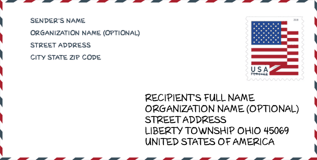
Envelope Example

This is an example of a US zip envelope. You can use a 5-digit zipcode or a detailed 9-digit zipcode to copy the mail in the following address format.
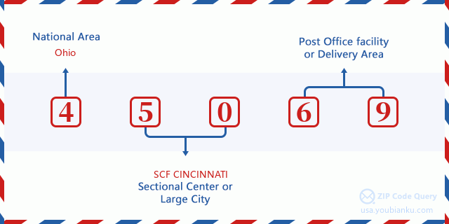
45069 Basic Meaning
What does each digit of ZIP Code 45069 stands for? The first digit designates a national area, which ranges from zero for the Northeast to nine for the far West. The 2-3 digits are the code of a sectional center facility in that region. The last two digits designate small post offices or postal zones.
Online Map

This is online map of the address West Chester, Ohio, United States. You may use button to move and zoom in / out. The map information is for reference only.
University

This is the ZIP Code 45069 - University page list. Its detail university Name, Street, City, State, ZIP Code, Phone is as below.
| Name | Street | City | State | ZIP Code | Phone |
| Aveda Fredric's Institute-Cincinnati | 7664 Voice of America Centre Drive | West Chester | OH | 45069 | (513) 533-0700 |
Hospital

This is the ZIP Code 45069 - Hospital page list. Its detail Hospital Name, Street, City, State, ZIP Code, Phone is as below.
| Name | Address | City | State | ZIP Code | Phone |
|---|---|---|---|---|---|
| WEST CHESTER HOSPITAL | 7700 UNIVERSITY DRIVE | WEST CHESTER | OH | 45069 | (513) 298-7700 |
| BECKETT SPRINGS | 8614 SHEPHERD FARM DRIVE | WEST CHESTER | OH | 45069 | (513) 942-9500 |
Museum

This is the ZIP Code 45069 - Museum page list. Its detail Museum Name, Street, City, State, ZIP Code, Phone is as below.
| Name | Street | City | State | ZIP Code | Phone |
| ENTERTRAINMENT JUNCTION | 7379 SQUIRE CT | WEST CHESTER | OH | 45069 | (513) 898-8000 |
| WILLIAM WOODWARD MEMORIAL MUSEUM | 9224 PATRIOT DRIVE | WEST CHESTER | OH | 45069 |
Library

This is the ZIP Code 45069 - Library page list. Its detail Library Name, Address, City, State, ZIP Code, Phone is as below.
| Name | Address | City | State | ZIP Code | Phone |
|---|---|---|---|---|---|
| MIDPOINTE LIBRARY SYSTEM - LIBERTY | 7100 FOUNDRY ROW | LIBERTY TOWNSHIP | OH | 45069 | (513) 705-8519 |
| MIDPOINTE LIBRARY SYSTEM - WEST CHESTER | 9363 CENTRE POINTE DRIVE | WEST CHESTER | OH | 45069 | (513) 777-3131 |
School
This is the ZIP Code 45069 - School page list. Its detail School Name, Address, City, State, ZIP Code is as below.
| School Name | Address | City | State | Grades | ZIP Code |
|---|---|---|---|---|---|
| Endeavor Elementary School | 4400 Smith Rd | West | OH | UG | 45069 |
| Butler Tech Bioscience Center | 8450 Capstone Boulevard | West Chester | OH | UG | 45069 |
Population for ZIP Code 45069

What is the total population in ZIP Code 45069? Below is detail information.
- Population for ZIP Code 45069: 56,815
- 2010 Population: 49,060
The 2020 demographic statistics are in progress. The current population in ZIP code 45069 is 56,815, and the population in 2010 is 49,060.
Gender

In all the statistical population, the male population is 24,139, the female population is 24,921.
- Male Population: 24,139
- Female Population: 24,921
Race

In all the statistical population, the male population is 24,139, the female population is 24,921.
- White Population: 41,371
- Black Population: 3,842
- Hispanic Population: 1,778
- Asian Population: 3,739
- Hawaiian Population: 74
- Indian Population: 250
- Other Population: 799
Age

In all the statistical population, the White population is 41,371, the Black population is 3,842, the Hispanic population is 1,778, the Asian population is 3,739, the Hawaiian population is 74, the Indian Ppopulation is 250 and Other population is 799.
- Age's Median: 38.9
- Median of male age: 38.0
- Median of female age: 39.6
Households for ZIP Code 45069
ZIP code 45069 has 17,717 households, with an average number of 2.75 persons per household. The average income per household in Zip code 45069 is 95,106 USD, and the average house value is 220,100 USD.
- Households Per Zipcode: 17,717
- Persons Per Household: 2.75
- Average House Value: 220,100
- Income Per Household: 95,106
Geographic

The latitude of the Zip code 45069 is 39.336464, the longitude is -84.413584, and the elevation is 704. It has land area of 28.438 square miles, and water area of 0.019 square miles. The time zone for ZIP code 45069 is Eastern (GMT -05:00). Daylight saving time should be observed in the area where the zip code is located.
- Latitude: 39.336464
- Longitude: -84.413584
- Elevation: 704
- Land Area: 28.438
- Water Area: 0.019
- Time Zone: Eastern (GMT -05:00)
- Region: Midwest
- Division: East North Central
- Day Light Saving: Y
Congressional District

The Congressional District for ZIP code 45069 is Ohio's 1st|08th congressional district, the Congressional Land Area is 686.96|2450.49 square mile.
- Congressional District: 1st|08th
- Congressional Land Area: 686.96|2450.49
Delivery

In the ZIP code 45069, there are 20,660 residential delivery mailboxes and centralized units, and 1,977 commercial delivery mailbox and centralized units, 14,363 single family deliveries and 3,713 multifamily deliveries, and the box count is 21,814. The main post office does not have city delivery carrier routes for the ZIP code 45069.
- Delivery Residential: 20,660
- Delivery Business: 1,977
- Delivery Total: 21,814
- Single Family Delivery Units: 14,363
- Multi Family Delivery Units: 3,713
- City Delivery Indicator: N
Business

In ZIP code 45069, the number of business is 1,745, the number of employee is 36,954, the business first quarter payroll is 487,283,000 USD, the business annual payroll is 1,861,254,000 USD.
- Number Of Businesses: 1,745
- Number Of Employees: 36,954
- Business First Quarter Payroll: 487,283,000
- Business Annual Payroll: 1,861,254,000
Social Security Benefits

There are 8,595 beneficiaries with benefits in current-payment status for ZIP code 45069, of which 6,555 are retired workers, 635 are disabled workers, 550 are widow(er)s and parents, 455 are spouses and 400 are children. The number of beneficiaries aged 65 or older is 7,185. The total monthly benefits are 13,739,000 USD, of which 11,175,000 USD for retired workers, 867,000 USD for widow(er)s and parents.
- Total Number: 8,595
- Retired workers Number: 6,555
- Disabled workers Number: 635
- Widow(er)s and parents Number: 550
- Spouses Number: 455
- Children Number: 400
- All beneficiaries per month: 13,739,000
- Retired workers per month: 11,175,000
- Widow(er)s and parents per month: 867,000
- Number of beneficiaries aged 65 or older: 7,185


Add new comment