United States ZIP Code: 45459
This is the Ohio ZIP Code 45459 page list. Its detail State, County, City, Longitude, Latitude, Envelope Example, Population is as below.

ZIP Code 45459 Information

ZIP Code 45459 - City

This is the city information corresponding to 45459:
| State | County | City | City Type ?In many cases, a ZIP Code can have multiple "names", meaning cities, towns, or subdivisions, in its boundaries. However, it will ALWAYS have exactly 1 "default" name. D - Default - This is the "preferred" name - by the USPS - for a city. Each ZIP Code has one - and only one - "default" name. In most cases, this is what people who live in that area call the city as well. A - Acceptable - This name can be used for mailing purposes. Often times alternative names are large neighborhoods or sections of the city/town. In some cases a ZIP Code may have several "acceptable" names which is used to group towns under one ZIP Code. N - Not Acceptable - A "not acceptable" name is, in many cases, a nickname that residents give that location. According to the USPS, you should NOT send mail to that ZIP Code using the "not acceptable" name when mailing. | ZIP Code |
|---|---|---|---|---|
| OH | Montgomery | Centerville | A (Acceptable) | 45459 |
| OH | Montgomery | Dayton | D (Default) | 45459 |
| OH | Montgomery | Kettering | A (Acceptable) | 45459 |
| OH | Montgomery | Moraine | A (Acceptable) | 45459 |
| OH | Montgomery | Sugarcreek Township | A (Acceptable) | 45459 |
| OH | Montgomery | Sugarcrk Twp | A (Acceptable) | 45459 |
| OH | Montgomery | Washingtn Twp | A (Acceptable) | 45459 |
| OH | Montgomery | Washington Township | A (Acceptable) | 45459 |
❓What does D (Default) mean? This is the "preferred" name - by the USPS - for a city. Each ZIP Code has one - and only one - "default" name. In most cases, this is what people who live in that area call the city as well.
❓What does A (Acceptable) mean? This name can be used for mailing purposes. Often times alternative names are large neighborhoods or sections of the city/town. In some cases a ZIP Code may have several "acceptable" names which is used to group towns under one ZIP Code.
ZIP Code 45459 Plus 4
ZIP Code 5 plus 4 is the extension of 5-digit zip code, It can be used to locate a more detailed location. The last four digits designate segment or one side of a street or an apartment. You can find the ZIP+4 code and corresponding address of the zip code 45459 below.
| ZIP Code 5 Plus 4 | Address |
|---|---|
| 45459-1100 | 2200 WINTERS RD, DAYTON, OH |
| 45459-1101 | 2101 WINTERS RD, DAYTON, OH |
| 45459-1102 | 2100 WINTERS RD, DAYTON, OH |
| 45459-1103 | 1701 W ALEX BELL RD, DAYTON, OH |
| 45459-1104 | 1700 W ALEX BELL RD, DAYTON, OH |
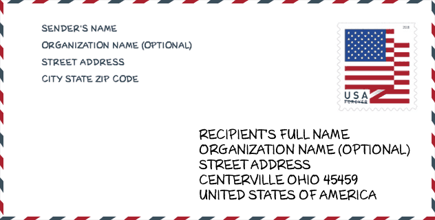
Envelope Example

This is an example of a US zip envelope. You can use a 5-digit zipcode or a detailed 9-digit zipcode to copy the mail in the following address format.
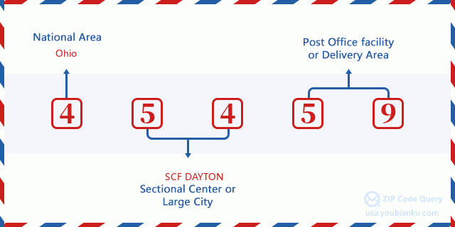
45459 Basic Meaning
What does each digit of ZIP Code 45459 stands for? The first digit designates a national area, which ranges from zero for the Northeast to nine for the far West. The 2-3 digits are the code of a sectional center facility in that region. The last two digits designate small post offices or postal zones.
Online Map

This is online map of the address Washington Township, Ohio, United States. You may use button to move and zoom in / out. The map information is for reference only.
University

This is the ZIP Code 45459 - University page list. Its detail university Name, Street, City, State, ZIP Code, Phone is as below.
| Name | Street | City | State | ZIP Code | Phone |
| Creative Images Institute of Cosmetology-South Dayton | 568 Miamisburg-Centrville Rd | Dayton | OH | 45459 | (937) 433-1944 |
| David-Curtis School of Floral Design | 209 N Main St. | Centerville | OH | 45459 | - |
| Regency Beauty Institute-Dayton | 2040 Miamisburg-Centerville Road | Dayton | OH | 45459 | - |
Library

This is the ZIP Code 45459 - Library page list. Its detail Library Name, Address, City, State, ZIP Code, Phone is as below.
- Name: WOODBOURNE LIBRARY
- Address: 6060 FAR HILLS AVE
- City: CENTERVILLE
- State: OH - Ohio
- ZIP Code: 45459
- Phone: (937) 435-3700
Population for ZIP Code 45459

What is the total population in ZIP Code 45459? Below is detail information.
- Population for ZIP Code 45459: 28,905
- 2010 Population: 27,749
The 2020 demographic statistics are in progress. The current population in ZIP code 45459 is 28,905, and the population in 2010 is 27,749.
Gender

In all the statistical population, the male population is 12,940, the female population is 14,809.
- Male Population: 12,940
- Female Population: 14,809
Race

In all the statistical population, the male population is 12,940, the female population is 14,809.
- White Population: 25,812
- Black Population: 1,122
- Hispanic Population: 534
- Asian Population: 998
- Hawaiian Population: 37
- Indian Population: 163
- Other Population: 175
Age

In all the statistical population, the White population is 25,812, the Black population is 1,122, the Hispanic population is 534, the Asian population is 998, the Hawaiian population is 37, the Indian Ppopulation is 163 and Other population is 175.
- Age's Median: 47.9
- Median of male age: 46.3
- Median of female age: 49.3
Households for ZIP Code 45459
ZIP code 45459 has 12,408 households, with an average number of 2.19 persons per household. The average income per household in Zip code 45459 is 72,292 USD, and the average house value is 199,100 USD.
- Households Per Zipcode: 12,408
- Persons Per Household: 2.19
- Average House Value: 199,100
- Income Per Household: 72,292
Geographic

The latitude of the Zip code 45459 is 39.652441, the longitude is -84.162778, and the elevation is 910. It has land area of 14.108 square miles, and water area of 0.055 square miles. The time zone for ZIP code 45459 is Eastern (GMT -05:00). Daylight saving time should be observed in the area where the zip code is located.
- Latitude: 39.652441
- Longitude: -84.162778
- Elevation: 910
- Land Area: 14.108
- Water Area: 0.055
- Time Zone: Eastern (GMT -05:00)
- Region: Midwest
- Division: East North Central
- Day Light Saving: Y
Congressional District

The Congressional District for ZIP code 45459 is Ohio's 10th congressional district, the Congressional Land Area is 1129.76 square mile.
- Congressional District: 10th
- Congressional Land Area: 1129.76
Delivery

In the ZIP code 45459, there are 13,199 residential delivery mailboxes and centralized units, and 1,691 commercial delivery mailbox and centralized units, 9,321 single family deliveries and 1,948 multifamily deliveries, and the box count is 16,834. The main post office has city delivery carrier routes for the ZIP code 45459.
- Delivery Residential: 13,199
- Delivery Business: 1,691
- Delivery Total: 16,834
- Single Family Delivery Units: 9,321
- Multi Family Delivery Units: 1,948
- City Delivery Indicator: Y
Business

In ZIP code 45459, the number of business is 1,398, the number of employee is 21,730, the business first quarter payroll is 198,994,000 USD, the business annual payroll is 820,438,000 USD.
- Number Of Businesses: 1,398
- Number Of Employees: 21,730
- Business First Quarter Payroll: 198,994,000
- Business Annual Payroll: 820,438,000
Social Security Benefits

There are 7,515 beneficiaries with benefits in current-payment status for ZIP code 45459, of which 6,010 are retired workers, 435 are disabled workers, 515 are widow(er)s and parents, 345 are spouses and 210 are children. The number of beneficiaries aged 65 or older is 6,665. The total monthly benefits are 12,079,000 USD, of which 10,135,000 USD for retired workers, 816,000 USD for widow(er)s and parents.
- Total Number: 7,515
- Retired workers Number: 6,010
- Disabled workers Number: 435
- Widow(er)s and parents Number: 515
- Spouses Number: 345
- Children Number: 210
- All beneficiaries per month: 12,079,000
- Retired workers per month: 10,135,000
- Widow(er)s and parents per month: 816,000
- Number of beneficiaries aged 65 or older: 6,665


Add new comment